Unfolding: Storm to unleash life-threatening flash flooding, damaging winds in Northeast


Less than three days on the heels of a storm that brought heavy snow over the interior Northeast and drenching rain on the mid-Atlantic coast, a stronger, larger and warmer storm has begun to swing through the region. As winds howl, temperatures surge and rain pours down, dangerous to life-threatening conditions will unfold due to rapid flooding and falling trees through midweek, AccuWeather meteorologists warn.
A dramatic chain of weather events will unfold in a matter of hours across the Northeast.
A large and furious storm has taken shape over the Central states and will continue to strengthen on Wednesday. As this storm tracks through the Midwest, its massive and strong circulation will pull in much warmer air from the Gulf of Mexico and the Atlantic Ocean on powerful south-to-southeast winds.
A rapid thaw will occur in areas with snow on the ground in the Northeast. However, major flooding will extend well beyond where there is any snow cover.
Following a burst of heavy snow or wintry mix into Tuesday night over parts of the Appalachians, "the most notable impact from the strengthening storm in the Northeast will be high winds and flooding rainfall," AccuWeather Senior Meteorologist Dan Pydynowski said.
The heavy snow and wintry mix will rapidly cover roads and make for slippery travel for the first few hours of the storm as it moves along before temperatures surge well above freezing and a switch to drenching rain occurs.
 |
Gusts frequenting 40-60 mph Tuesday night led to regional power outages, with hundreds of thousands of customers left without power for a time in Pennsylvania, New York and New Jersey.
The strongest winds moving forward will be along the Atlantic coast, over the ridges of the Appalachians and to the southeast of lakes Erie and Ontario.
Tree and property damage are likely. Large tree limbs may come crashing down on sidewalks, vehicles, homes and businesses without notice. Trash cans and other unsecured items in neighborhoods may become projectiles.
Power outages could be widespread and long-lasting, especially in remote, heavily wooded areas.
The storm will quickly gather a great deal of moisture from the Gulf of Mexico and the Atlantic and wring that moisture out over the Northeast.
"A general 1-3 inches of rain alone that falls on the saturated ground from prior storms back through December is enough to lead to rapid flooding in poor drainage areas and along small streams," Pydynowski stated.
Localized rainfall amounts may approach 5 inches. When combined with areas with nearly a foot of snow on the ground and water locked up within the snow, the combined rain and melting snow effect may unleash 3-6 inches of water in a few hours, hence the flash flood concern.
Because much of the rain coming from the next storm through Wednesday will occur in a matter of several hours and will be combined with melting snow, many streams and some of the major rivers will rise extremely fast and flood unprotected areas with little notice, Pydynowski warned.
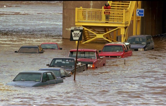
While there will be much less snow on the ground when compared to early January 1996, there is the potential for a rapid meltdown and flooding event similar to what occurred in the region nearly 27 years ago.
 |
Flooding on the Allegheny River wharf in downtown Pittsburgh leaves some cars parked Friday morning by commuters under water late Friday afternoon Jan. 19, 1996, as the river rises from the combined effect of melting snow and rain. |
The flash flooding could be so significant that it may also threaten lives in extreme cases. Some roads that appear to have only shallow water may have been washed away. A surge of high water may cascade down small streams, underpasses and drainage basins with little warning.
Flooding problems will extend well beyond areas where there is snow on the ground and will extend throughout the I-95 corridor of the mid-Atlantic and New England in cities from Washington, D.C., to Philadelphia, New York City, Boston and many others. Major travel disruptions are expected to continue through Wednesday morning's rush hour.
 |
Property owners and township supervisors in the Northeast are urged to closely monitor the flood potential. The sudden rush of water down mountainsides into the valleys could lead to some roads becoming washed out or blocked with debris.
While water levels on the major rivers may begin to respond to the rain and runoff almost immediately, it may not be until later Wednesday, Thursday and Friday until a crest occurs on the largest waterways. Most rivers in New Jersey, eastern Pennsylvania, Virginia, the Carolinas, Maryland, Delaware, eastern New York, Connecticut, Rhode Island, Massachusetts and the southern parts of New Hampshire, Vermont and Maine will likely reach minor to major flood stage during this event.
In addition to freshwater flooding, the strong south-to-southeast winds will push ocean and bay water into low-lying areas. The coastal flooding will occur around times of high tide into the midday hours on Wednesday.
Yet another storm could bring a surge of mild air and more rain to the region during the second weekend of January, resulting in a resurgence of high water and flooding problems in the Northeast.
 |
That storm is highly likely to bring blizzard conditions to multiple states in the Midwest from Thursday night to Saturday as the first major outbreak of Arctic air of the winter reaches from the Midwest to the Central states. As the Arctic air reaches into the East at midmonth, it could finally trigger a winter storm for relieving the snow drought in areas of the mid-Atlantic.
Want next-level safety, ad-free? Unlock advanced, hyperlocal severe weather alerts when you subscribe to Premium+ on the AccuWeather app. AccuWeather Alerts™ are prompted by our expert meteorologists who monitor and analyze dangerous weather risks 24/7 to keep you and your family safer.
