Northeast weather to turn from wet to wintry this week


A coastal storm paralleling the Northeast Coast will not only bring wet weather that could slow travel for the end of the holiday weekend, but also bring in more cold and snow in the week ahead.
For some coastal locations, this bout of wet weather will be welcome following a very dry November.
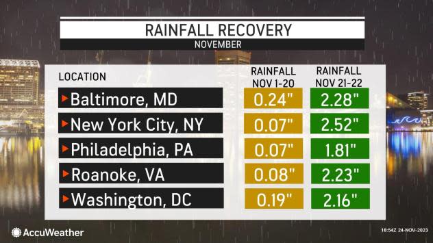
The first two-thirds of the month of November was quite dry, with cities like New York City and Philadelphia reporting under 0.10 of an inch of rain, well below the historical average for this time of year. The dry stretch put portions of Pennsylvania, Virginia and Maryland in a moderate drought.
 |
However, stormy weather struck for the end of the month. November 21-22 turned especially wet with more than 2 inches of rain falling in just two days for Washington, D.C. up into New York City.
AccuWeather meteorologists say that another round of rain is coming for the mid-Atlantic coast up into New England, continuing the wet stretch before the calendar changes to December.
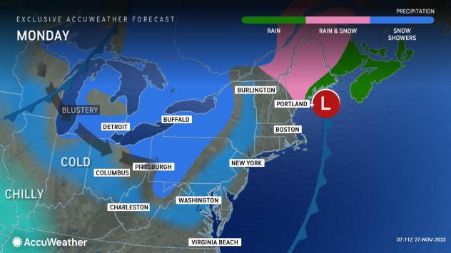
"This coastal storm is expected to douse the cities along Interstate 95 from eastern Virginia to Maine into Monday," said AccuWeather Senior Meteorologist Tyler Roys.
The storm, which first strengthened off the coasts of the Maryland and Delaware beaches late on Sunday, will be racing northeastward through early Monday. During this time, the heaviest rain focused along the coasts of these states up to Rhode Island and eastern Massachusetts. By early Monday morning, the heaviest rain had raced out of Southern New England and was focused on southern Maine and northern New Hampshire.
Total rainfall amounts of half an inch to an inch are expected along the East Coast from Atlantic City, New Jersey to Portland, Maine, with some localized amounts of an inch or more from New York City to southeastern New England.
 |
Farther north, enough cold air will be pulled southward from Canada to allow for snow to mix in with the rain across portions of New Hampshire and Maine through Monday, especially in the higher terrain.
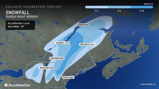
A more widespread swath of 1-3" of snow is expected from the Adirondack Mountains of northern New York to northern New Brunswick in Canada. Over half a foot of snow is forecast for the highest terrain of New Hampshire to far northwestern Maine.
"For ski resorts across northern Maine, this snow should bring an early season boost to their snow bases," explained Roys.
 |
Behind the wet weather along the coast from this storm, more wintry conditions will follow right behind.
Have the app? Unlock AccuWeather Alerts™ with Premium+
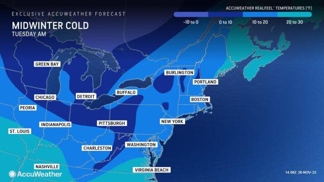
A southward dip in the jet stream is expected to allow cooler air to pool across the Great Lakes and Northeast through much of the week. Temperatures are forecast to dive into the teens for the interior Northeast, and into the 20s closer to the Atlantic Coast.
 |
Gusty winds are forecast to make it feel even colder than the actual air temperatures, dropping AccuWeather RealFeel® Temperatures into the teens for the major cities, and even below zero for parts of the interior Northeast on Tuesday morning.
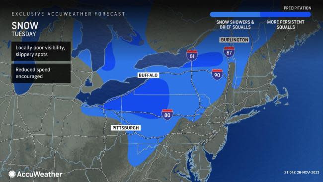
The cooler air rushing over the Great Lakes is expected to bring the first major lake-effect snow event of the season for parts of northeastern Ohio, northern and western Pennsylvania and New York. In the steadiest bands, some locales could see over a foot of snow early next week.
"Caution will be needed for those who live east of the Great Lakes with any lake-effect snow and snow squalls as conditions can quickly deteriorate to no visibility, making it hard to travel," said Roys.
AccuWeather forecasters say that, given this chilly and active pattern, residents across the Great Lakes and Northeast should be on alert for more opportunities for snow, especially through on Tuesday.
"There is growing concern that in addition to snow showers encompassing much of the interior Northeast on Tuesday, that snow squalls may be more expansive compared the rest of the lake-effect event," Roys added.
 |
Snow squalls are notorious for taking a what seems like a typical cloudy day and then suddenly there is a significant drop in visibility, making it difficult to see on the roads, and especially interstates. Motorists across portions of Interstate 80 should take caution while traveling early this week, especially on Tuesday.
Want next-level safety, ad-free? Unlock advanced, hyperlocal severe weather alerts when you subscribe to Premium+ on the AccuWeather app. AccuWeather Alerts™are prompted by our expert meteorologists who monitor and analyze dangerous weather risks 24/7 to keep you and your family safer.
