Storm unleashes heavy rain and strong winds as drastic temperature swings occur in northeastern US
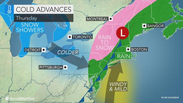
A storm will continue to bring heavy rain, powerful winds, travel delays and a change back to snow in some areas of the Northeast into Thursday evening.
Actual temperatures are surging 30 to 60 degrees Fahrenheit from their lowest point this past Monday morning to the peak of the warmth on Thursday.
For example, at Boston during Monday morning, the actual temperature was 5 F. Temperatures were closing in on 60 F during Thursday afternoon.
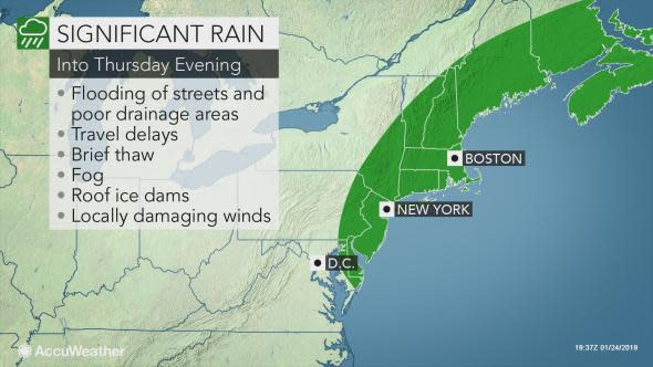
Enough rain is pouring down during the height of the storm to cause water to collect on the highways. Flooding in city streets and other poor drainage areas can occur. The flooding may not be limited to areas with snow on the ground or where snow is piled in front of storm drains.
Urban flooding can occur in the major I-95 cities, including New York City and Boston. Flooding near the coast of New Jersey led to road closures on Thursday.
Strong wind gusts have been accompanying the rain, leading to tree damage and blocked roads in southeastern New England. The oversized load of a tractor trailer was overturned outside of Boston during the early afternoon.
There can be gusts of 50 to 60 mph from Long Island to eastern New England with localized gusts to 70 mph. Such winds can down trees and wires, leading to power outages. Some roads may become impassible due to the storm debris.
Thursday's winds are being blamed for blowing a portion of a roof off a home in Manchester, New Hampshire, and downing traffic signals in Hopkinton, Massachusetts.
Drivers of high-profile vehicles should use caution for dangerous crosswinds.
DXFD handling numerous calls for wires and trees down. This is on Myrtle St large tree and primaries down. Road impassable. #weather pic.twitter.com/v4KitlPFJX
— Duxbury Fire PIO (@DXFD_PIO) January 24, 2019
The combination of the quick thaw and drenching rain can trigger minor ice jam flooding on some of the rivers of the Northeast on Thursday. People living along unprotected low-lying areas of streams and rivers where ice has formed should remain vigilant as conditions can change by the hour.
In northern Ohio, ice jams are flooding roads and homes near the mouths of the Chagrin and Vermilion rivers.
Ice jams were reported in Vermont on Thursday afternoon, including on the Outtaquqechee River in Woodstock, Vermont.
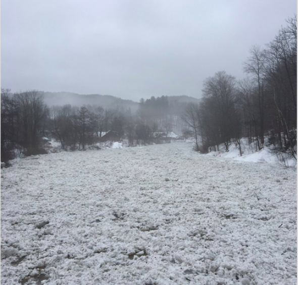
An ice jam on the Outtauquechee River in Woodstock, Vermont. (Photo/Scott Noble)
"A repeat of the widespread rapid meltdown and flash flooding like that of January 1996 is not anticipated at this time, since less rain is likely to fall and there is generally much less snow over a less widespread area this time," according to AccuWeather Chief Meteorologist Elliot Abrams.
A general 1 to 1.50 inches of rain is forecast with local amounts between 2 and 3 inches possible.
DXFD on scene Marshal St with a tree down on a garage. Building inspector notified. We continue to see high wind gusts. #weather pic.twitter.com/a0HRYZN0KE
— Duxbury Fire PIO (@DXFD_PIO) January 24, 2019
In addition to the risk of urban flooding, locally dense fog will accompany the rain for a time. The fog is most likely in areas where snow remains on the ground a short time after the rain has begun and may continue until the conclusion of the storm or the snow has completely melted.
Rain, fog and locally gusty winds may be a problem for motorists and flights. Expect travel delays during the height of the storm.
Due to strong winds this afternoon, some flights are being impacted. We urge passengers to contact their airline for the best information about their flight. Airlines at BOS: https://t.co/rrLmWL5cRw
— Boston Logan Airport (@BostonLogan) January 24, 2019
Meanwhile, colder air will sweep in behind the storm.
Even though this air is initially not nearly as cold as the air that blasted in during Sunday and Monday, it will be cold enough to allow a change to snow across upstate New York and the interior of northern New England into Thursday evening.
The rain is much more likely to simply end east of the Appalachians from New York City to Boston and Portland, Maine. It may still get cold enough, fast enough to cause untreated wet areas and puddles to freeze later Thursday night to Friday morning.
Another blast of Arctic air is forecast to close out the week.
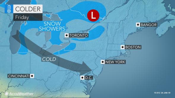
Winds may be less fierce with the new shot of cold air, and temperatures are not likely to remain at low levels for as long as they were during the previous cold blast.
"With the sudden and large temperature fluctuations, there will be an increased risk of water main breaks and potholes," Abrams said.
A repeat of the brutal cold endured earlier this week may come at the end of January as the polar vortex plunges southward.
Download the free AccuWeather app to see when the rain and gusty winds will end in your community.
Join host Regina Miller as she examines Forensic Meteorology and the reconstruction of weather events for legal testimonies. Steve Wistar, AccuWeather's Forensic Meteorologist and Certified Consulting Meteorologist recalls prominent legal cases where winter weather played a key role in the verdicts.

TradeWx offers protection against financial risks of snow accumulation and other weather events. Learn more on TradeWx.com.

