Northern California braces for more rain, snow and wind. Here’s the forecast and flood risk
Original story, published Monday, March 13:
Enjoy the last few hours of quiet as the next atmospheric river storm approaches Northern California, bringing the far too familiar quartet: rain, snow, gusty winds and thunderstorms.
According to the National Weather Service, this warm storm will slam the Golden State Monday night, increasing the risk of flooding and high river levels. The storm is forecast to subside Wednesday but residual flood water could make its way through state rivers.
California Gov. Gavin Newsom expanded the storm state of emergency in 34 counties to include an additional six: Calaveras, Del Norte, Glenn, Kings, San Benito and San Joaquin.
Last week, President Joe Biden signed off on Newsom’s request for federal assistance to support storm efforts across the state.
Here’s a look at the latest storm timeline and river levels in Northern California:
Northern California storm timeline
The strongest part of the storm will hit the region Monday night and Tuesday, possibly leaving Sacramento with between 1 inch to 2 inches of rain, said meteorologist Idamis Del Valle-Shoemaker with the National Weather Service.
The weather service issued a wind advisory, high wind watch and a high wind warning for for areas across the region.
Winds are forecast to blow all day Tuesday, between 25 mph to 35 mph. Gusts could whip from 45 mph to 60 mph.
“This will cause downed trees and power outages, especially with soils so saturated,” National Weather Service wrote on its Twitter page.
A High Wind Warning will be in effect from 5 AM - 11 PM Tuesday. Expect wind gusts 45-55 mph, with localized gusts up to 60 mph. This will cause downed trees and power outages, especially with soils so saturated. Now is the time to prepare if you have not already! #cawx pic.twitter.com/9J6a1CMVQz
— NWS Sacramento (@NWSSacramento) March 13, 2023
Thunder and lightning won’t help.
Parts of Chico, Yuba City, Sacramento, Stockton and Modesto could be hit with isolated thunderstorms Monday afternoon. Here’s what to prepare for, according to the National Weather Service:
Lightning
Small hail
Brief heavy rain
Gusty winds
Funnel clouds
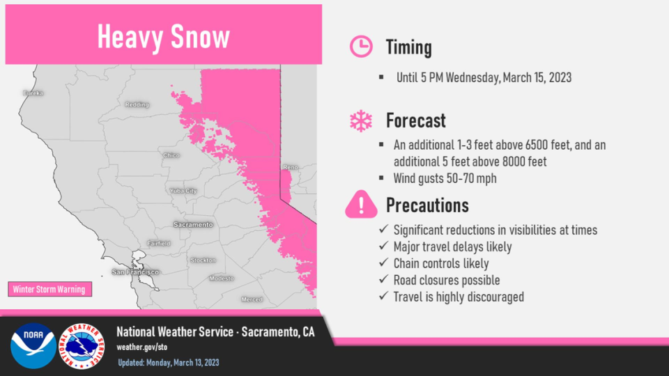
UC Berkeley Central Sierra Snow Lab received roughly 1 foot of snow in 24 hours, as of Tuesday morning, and is expecting between 1 foot to 2.5 feet of snow Tuesday.
Snow levels are 6,500 to 8,500 feet through midday Wednesday. A winter storm warning is in effect until 5 p.m., as elevations above 8,000 could see 5 more feet of snow.
Here’s a look at the Northern California storm timeline:
Showery weather will continue across interior #NorCal today. Another strong storm will move into the region tonight and Tuesday bringing increasing wind and precipitation with renewed flooding concerns. #CAwx pic.twitter.com/5zJKehbJ64
— NWS Sacramento (@NWSSacramento) March 13, 2023
In case you’re looking for some good news in all of this: California is experiencing some relief from its historic drought.
California drought update: Interactive map shows latest ahead of atmospheric river storm
Northern California river levels and flood risk
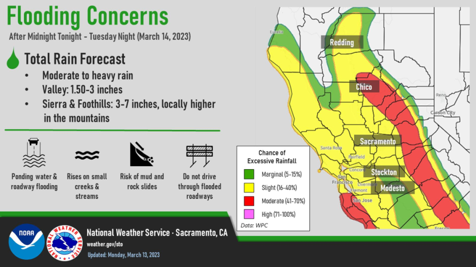
The moderate to heavy rain expected to start Monday night poses flood risks across the region.
Between 1 to 3 inches of rain is expected in Sacramento Valley. The Sierra foothills are preparing for 3 to 7 inches of rain. Flood risk is greatest in the lower-elevation foothills, according to the weather service map.
River levels in the region are also being monitored, and the Cosumnes River could see some flooding.
As of Tuesday morning, the south Sacramento County river at McConnell was several feet above its monitor stage at 38.5 feet. Its flood stage is 42 feet.
The California Nevada River Forecast Center says the river could rise to 42.4 feet by Wednesday afternoon.
Michigan Bar follows a similar trend.
The river was above its monitor stage Tuesday morning and is forecast to rise above its flood stage to 13 feet by Tuesday night.
The monitor stage for the Sacramento River at I Street is 27.5 feet and the flood stage is 33.5 feet. As of Tuesday morning, the river is at 27.1 feet and is projected to rise to 28.5 feet by early Wednesday morning.
The monitor stage for the American River at the H Street Bridge is 39 feet and the flood stage is 42. As of Tuesday morning, the river was at 30.4 feet and is not projected to rise much more.

