Storm updates: Rain, wind, blizzard conditions, debris flows to hit Northern California
The largest winter storm of the season is barreling toward California and is expected to bring extreme weather from San Diego to San Francisco, Sacramento to the Sierra.
This storm, forecasters say, has it all: Brutal winds, torrential rain, blizzard conditions, blinding snow, the threat of mudslides and debris flows, power outages and more.
Live updates: Sacramento cleans up after California storm’s winds pull down trees, cut power
“This is definitely looking like the storm of the year up to this point,” Hannah Chandler-Cooley, a forecaster with the National Weather Service’s Sacramento office said Monday.
And it’s all due to a so-called atmospheric river — a conveyor belt of unsettled moisture 300 miles wide — that pushes its way from the Pacific on shore. These rivers in the sky can cause a lot of damage quickly: Powerful atmospheric river systems like this week’s have been responsible for most of California’s biggest storm and flooding in the past few years.
Researches told The Sacramento Bee last year that atmospheric rivers — a phrase first coined in 1998 — often cause more than $1 billion in damage annually.
“We’ve known for some time that they cause extreme precipitation, caused hydrologic flooding and we’ve known that certain storms have had significant economic impacts but we didn’t know just how much,” said Thomas Corringham, a UC San Diego professor who focuses on the social and economic impacts of extreme weather events.
Very cool "Lagrangian" (fluid-following) satellite view of California's incoming powerful storm system as it strengthens and approaches the North Coast. #CAwx https://t.co/O92GggBJ4F
— Daniel Swain (@Weather_West) January 26, 2021
Here’s the latest on the storm, and what’s expected:
When does the storm arrive?
Tuesday night, when the storm hits the North Coast and sweeps across the North Bay and the northern tier of the Sacramento Valley. In the early evening, winds ahead of the storm are expected to ramp up, with gusts of 20 to 30 mph consistently. In the higher elevations, those gusts may get higher than 50 mph, forecasters said.
According to Daniel Swain, a climate scientist at UCLA’s Institute of the Environment and Sustainability, the cold front is “unusually well defined” and replaces an already cold air mass with another. It is the third storm system to come from the North Pacific since Friday.
“The cold frontal passage is expected to be quite dramatic across NorCal in the overnight hours,” Swain wrote on social media Tuesday morning. He said the “rapidly intensifying” rain band “could bring a period of torrential rain or snow to many areas, as well as possible lightning.”
National Weather Service forecasters said the storm will bring heavy wind gusts across the northern half of the state overnight, as well.
Swain said high-resolution models “are suggesting potential for gusts of 60-70 mph even in lower elevation places. Widespread power outages possible.”
Thread on very strong inbound CA storm. A cold & clear morning will quickly give way to increasing clouds, NorCal valley rain & snow down to 1,500-2,000 ft (locally lower) later this PM. Current satellite imagery shows this strengthening system off the coast. (1/10) #CAwx pic.twitter.com/1LoomMXzQC
— Daniel Swain (@Weather_West) January 26, 2021
Sacramento Valley: Power outages anticipated, snow possible?
The NWS has winter storm watches or warnings in place from Tuesday through Friday for effectively all of the mountains, foothills and some of the northern third of the Sacramento Valley. High-wind warnings are in effect until noon Wednesday across the Sacramento Valley and extend as far south as Madera.
The Sacramento region could see up to 3 inches of rain this week – perhaps doubling the amount of rain received for the entire winter season to this point – as the storm arrives. The cold, wet system will bring dangerous winds to the region and localized flooding
Swain says the storm could bring “a very rare heavy snowfall event” for the Sacramento Valley.
“Some places near the Valley floor (near Redding and even Red Bluff) could see a foot or more of accumulation,” he said on Twitter. “Some lighter snow possible even south of that ... That very rare, heavy and wet snowfall in the North Valley could lead to widespread disruption and power outages.”
Snow could fall at elevations as low as 500 feet Tuesday night into Wednesday morning, but those low snow levels are most likely in Tehama, Butte and Shasta counties in the northern reaches of the Sacramento Valley, prompting some to compare it to the snowfall the Redding area saw a year ago.
“If Snowmaggedon 2019 and the entirety of 2020 taught us nothing, it is to be prepared for anything, even while you remain hopeful for the best,” the Shasta County Sheriff’s Office posted on Facebook Tuesday.
Closer to Sacramento, snow could fall as low as 1,000 or 1,500 feet, so areas around Auburn and Placerville may see accumulations.
The Sacramento Valley, along with the Bay Area, will get a dumping of rain. Forecasts show 2 to 3 inches falling between Tuesday and Friday in Sacramento; 7½ inches could fall in Grass Valley.
️Strong & damaging southerly winds are forecast to develop this evening and tonight across NorCal. ️
Here's an hour-by-hour look at the high winds that are forecast to impact NorCal. Note wind gusts in some communities are forecast to reach the 50 to 60+ mph range! #CAwx pic.twitter.com/MiwI4ssx2F— NWS Sacramento (@NWSSacramento) January 26, 2021
@NWSSacramento says, a high impact #WinterStorm will be moving in later today & continue into Friday. Our region could see up to 3” of #rain this week. Be prepared! Clear out gutters. Give yourself extra time for your commute. Avoid traveling to the mountains. Dress warmly. pic.twitter.com/DKkdJhTHZn
— Sacramento Fire Department (@SacFirePIO) January 26, 2021
After a hard freeze Tuesday morning, forecasts show gusts could reach 55 mph by Tuesday evening. An inch of rain is possible Tuesday night, and while Wednesday is expected to bring less precipitation, winds could again gust very high, up to around 45 mph in Sacramento.
That means the Wednesday morning commute will likely be a mess, the NWS’ Chandler-Cooley said. Rain will likely pond on roadways and some localized flooding is possible. Gusts near 50 mph will almost certainly knock down branches and small trees, and could lead to power outages.
The NWS in an infographic said the storm is expected to have “extreme” impact Tuesday and Wednesday in interior Northern California, “high” impact Thursday and may begin to subside by Friday.
Sierra Nevada: Travel discouraged, perhaps ‘impossible’
On Tuesday, Caltrans’ District 3 minced few words when urging motorists not to travel: “We cannot stress this enough — if you have not arrived to your destination before sunset tonight, travel to the Sierra is not advised. Heavy snow is on tap and whiteout conditions are expected.”
We cannot stress this enough - IF YOU HAVE NOT ARRIVED TO YOUR DESTINATION BEFORE SUNSET TONIGHT, TRAVEL TO THE SIERRA IS NOT ADVISED. Heavy snow is on tap and whiteout conditions are expected. Please make smart travel choices. https://t.co/V8g0VyBtK8
— Caltrans District 3 (@CaltransDist3) January 26, 2021
In the Sierra Nevada and Lake Tahoe region, forecasters are calling for between 3 and 6 feet of snow by the end of this week. Some models suggest up to 80 inches of snow could fall on the summits along Interstate 80 and Highway 50.
Winter storm warnings will remain in effect from north of Tahoe to as far south as Sequoia National Forest through 4 a.m. Friday.
On Tuesday, the weather service’s Reno office upped the ante, issuing a blizzard warning for the Lake Tahoe area, including South Lake Tahoe and Truckee on the California side and Stateline and Incline Village on the Nevada shore. Just after 1 p.m., it was expanded to more parts of Placer and El Dorado counties, as well as Amador, Alpine, Nevada, Sierra, Tuolumne, Calaveras and Mono. Forecasters even suggested thundersnow is possible.
Never forget. Jim Cantore. #thundersnow pic.twitter.com/Az8mAnsQUv
— Jennifer Botti *jB* (@BostonGaL4Ever) March 14, 2017
In the Sierra Nevada, the closure of Yosemite National Park was extended to at least Jan. 30. The park sustained heavy damage more than a week ago when it was battered by fierce winds that swept through California before the onset of the current storms.
Mountain travel “will be EXTREMELY DIFFICULT to near IMPOSSIBLE,” the National Weather Service’s Sacramento office tweeted Monday. They said wind gusts of close to 100 mph are possible at the highest peaks.
The anticipated snow totals are stunning. NWS predicted that 2 to 5 feet of snow could fall across the majority of the Sierra between Tuesday evening and Friday morning, with totals between 7 and 8 feet possible at some higher elevations. Blue Canyon, at around 5,000 feet elevation, could see up to 60 inches of snow.
Snow levels are expected to rise to 2,500 to 3,000 feet Wednesday, and then to between 3,000 and 4,000 feet Thursday morning.
If you’re a skier hoping to take advantage of the conditions, there might be some good news: Friday and Saturday might bring a reprieve from the dangerous conditions, Chandler-Cooley said, before another system potentially arrives on Sunday.
The Southwest Entrance sign might be a little harder to see after the park receives up to 96 inches (9 feet) of snow as forecasted for today through Thursday! The Manzanita Lake Area is expected to receive up to 48 (4 feet) of snow. ️️️ pic.twitter.com/rC1WYErQln
— Lassen Volcanic NP (@LassenNPS) January 26, 2021
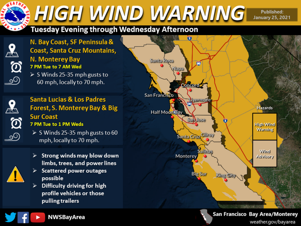
Bay Area: Evacuations orders in burn areas
The storm will blanket the Bay Area first and worst, forecasters have suggested, and could dump as much as 15 inches of rain in 48 hours in places like Santa Cruz and Big Sur.
“It’s gonna be powerful,” National Weather Service meteorologist Brayden Murdock told the Mercury News in San Jose. “Some areas will be doubling their rainfall totals as far what they’ve seen since this fall since October.”
UCLA’s Swain said more than an inch of rain per hour could fall in some Bay Area spots Tuesday night, posing the threat of debris flows in areas that suffered damage during the summer’s wildfires along the Central Coast.
“Then, on Wednesday, the #AtmosphericRiver/associated cold frontal rainband will likely stall along Central Coast,” he said, near the Monterey-San Luis Obispo county border. He added that models suggest the possibility of extreme 48-hour rainfall accumulations and “very high” flood and mudslide risks.

Debris flows — torrents carrying massive boulders, soil, trees and other objects — are considered more dangerous than mudslides or landslides. The Jan. 9, 2018, debris flow that blasted the Santa Barbara County community of Montecito killed 23 people.
Burn scars from the CZU Lightning Complex fire, could get a foot of rain or more, though the latest NWS update suggested it may see closer to 8 inches of precipitation. About 5,000 residents in Santa Cruz County were evacuated on Monday. More were ordered to leave on Tuesday in San Mateo County.
“Big areas covered by this warning are burn-scar areas, and they’ll all be susceptible to flooding,” Murdock told the Mercury News. “When these areas are burned, they seal themselves off and act as a cover to any moisture, and so it just skids along the top.”
Burn scars from the LNU Complex and other fires that swept through Sonoma and Napa counties are also watching the hills. Rainfall in the more-populated areas in the East and South Bay will be more manageable, forecasters say: between 2 and 4 inches, but flooding could happen in the coastal foothills that were burned by the SCU Lightning Complex.
Flash-flood watches are in effect across six counties: Sonoma, Napa, Marin, Contra Costa, Alameda and Santa Clara.
Murdock told SF Gate that residents near the burn scar shouldn’t let their guard down, as the risk of debris flows will stick around through Thursday.
“We need to continue the messaging that says be weather aware,” Murdock told the online news site. “Have your to-go bags packed.”
Southern California: Snow closes freeways, Grapevine
The previous storm, still pushing its way through Southern California, closed several major roadways, including both directions of Interstate 5 over the Grapevine.
The California Highway Patrol shut down the north-south arterial separating Los Angeles and Bakersfield because of heavy snow overnight. Highway 58 over the Tehachapi Pass was also closed, officials said. Caltrans recommended motorists with snow tires or chains use the treacherous Highway 178 through the Kern River Canyon to Lake Isabella if they need to reach Southern California.
Meanwhile, in San Diego County, some lanes of Interstate 8 were closed at Alpine, according to the Los Angeles Times.
Los Angeles and points south won’t see any rain from the atmospheric river until Thursday morning, but could receive as much as 2 inches, according to forecasters.
How to prepare an emergency kit
Whether it’s a winter storm, a wildfire or an earthquake, Californians should be prepared for an emergency. A year-round kit is easy and relatively inexpensive to create. The American Red Cross recommends having enough food, water and other supplies to last at least three days. Here are most of the items you’d need (a full list is on the Red Cross’ website):
Flashlights or battery-operated candles
Water: one gallon per person, per day for three days
Three-day supply of food: non-perishable, easy-to-prepare items
Battery-powered or hand-crank radio (NOAA Weather Radio, if possible)
Phone charger that can be used in a car or back-up battery supplies
Extra batteries
First aid kit
Medications (7-day supply) and medical items
Multi-purpose tool
Sanitation and personal hygiene items
Copies of personal documents (medication list and pertinent medical information, proof of address, deed/lease to home, passports, birth certificates, insurance policies)
Can opener
Family and emergency contact information
Extra cash
Extra blanket
Map(s) of the area
Matches or lighters
Cooler filled with ice
Extra propane or charcoal to be used on an outdoor grill
The Associated Press contributed to this report.

