Northern California weather: Expect delays on Interstate 5, Highway 89 as more storms arrive
North State residents will see more wind, rain and possible flooding and power outages this week as storms continue to roll over Northern California.
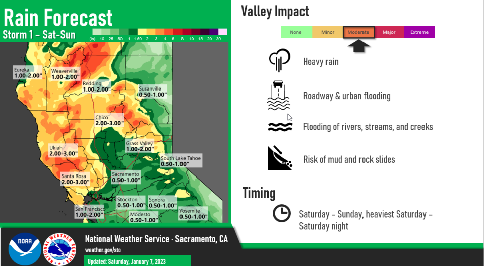
Up to two inches of rain will fall in Redding this weekend; more in other parts of the Northern California.
This week, motorists on Interstate 5, Highway 299 and other roads should watch for flooding, downed or damaged trees and power poles, and mud and rock slides, according to the California Department of Transportation and the National Weather Service. Snow will likely cause delays and road closures in the mountains.
The worst winds arrive Saturday night into Sunday morning, and the heaviest rain on Monday and Tuesday, according to the Weather Service's Sacramento branch.
From Sacramento and the San Joaquin Valley, north to Redding and the surrounding foothills, gusty southerly winds up to 45 mph that kick up Saturday night continue Sunday morning. Those winds are strong enough to cause power outages and knock down trees, the Weather Service said. Wind gusts will blow off and on Sunday afternoon through Tuesday.
Hard rain arrives on Monday, dumping three to four inches on Redding, Sacramento and Stockton by Tuesday night. Chico could get up to three inches of rain; Grass Valley up to five inches, the Weather Service said.
Temperatures reach the high 50s and drop to the low to mid-40s Sunday through Tuesday in Redding, said Weather Service meteorologist Robert Baruffaldi.
Meteorologists expect flooding along the Sacramento River and other waterways, Baruffaldi said. Water levels will rise quickly throughout the week as storms continue to flow through the area into next weekend.
Winter storm warning issued for mountain communities, I-5 corridor
Mountain communities and motorists can expect more snow on Sunday.
The Weather Service's Medford branch issued a winter storm warning, in effect until 10 a.m. Sunday, for most of Siskiyou County. Mount Shasta, the Mt. Shasta Ski Park and areas at or above 4,000 feet could get as much as an inch of snow per hour.
The I-5 corridor around Mount Shasta and southwestern Siskiyou County could get eight inches of snow this weekend. Up to another inch will fall on Monday and Tuesday.
Motorists will see the worst snow impacts on Interstate 5 near Black Butte Summit and on Highway 89 near McCloud, Cassel and Mount Shasta, the Weather Service said. Other roads likely to have delays include areas west of Etna, Grayback and other parts of western Siskiyou County.
Highway 3 is near Scott Mountain was still closed on Saturday due to winter weather conditions, Caltrans said.
First responders are watching burn scar areas for flash flooding, including those from recent fires in and around Weed and Happy Camp, the Siskiyou county Sheriff's Office said last Thursday.
Jessica Skropanic is a features reporter for the Record Searchlight/USA Today Network. She covers science, arts, social issues and entertainment stories. Follow her on Twitter @RS_JSkropanic and on Facebook. Join Jessica in the Get Out! Nor Cal recreation Facebook group. To support and sustain this work, please subscribe today. Thank you.
This article originally appeared on Redding Record Searchlight: Expect delays on Interstate 5, Highway 89; more Northern California storms on way

