Hurricane Lee explodes to Category 5 strength prior to Caribbean, US impacts


Hurricane Lee has undergone a rapid intensification, reaching Category 5 strength and packing 165-mph winds early Friday morning. Just 24 hours prior, it had been an 80-mph Category 1 hurricane. The monster storm will chart a lengthy course across the Atlantic, bringing impacts from the Caribbean islands to the United States and Atlantic Canada, AccuWeather meteorologists say.
Lee, which was named in the central Atlantic on Tuesday, was packing winds of 155 mph (Category 4 intensity) and located about 565 miles east of the Leeward Islands of the eastern Caribbean early Friday morning. It now holds the title of the strongest hurricane to churn in the Atlantic during the 2023 season.
 |
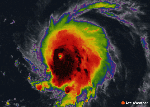
Hurricane Lee on infrared satellite on the morning of Sept. 8. |
"Rapid strengthening occurs when a tropical system's winds increase by 35 mph or greater within 24 hours," AccuWeather Senior Meteorologist Alex Sosnowski said. "As we warned about on Thursday, Lee mirrored what Hurricane Jova did in the eastern Pacific." Jova more than double-downed on the strengthening process with winds increasing by a whopping 86 mph in 24 hours from Wednesday to Thursday. Lee has followed course, with winds more than doubling from Thursday to Friday morning.
Rapid intensification at this level is rare.
"Wilma, from the 2005 mega hurricane season, holds the record for 24-hour rapid intensification in the Atlantic basin," AccuWeather Senior Meteorologist Bill Deger said. "The system's sustained winds ramped up 105 mph from a 70-mph tropical storm to a 175-mph Category 5 hurricane in 24 hours."
"Changes within the eye of the hurricane will cause some minor fluctuation in strength into this weekend," AccuWeather Chief On-Air Meteorologist Bernie Rayno said.
So far this season, the Atlantic Basin has spawned two major hurricanes, Franklin and Idalia, both of which reached peak strength as Category 4 hurricanes on the Saffir-Simpson Hurricane Wind Scale with sustained winds between 130 and 156 mph. Lee has become even stronger than both Franklin and Idalia, reaching Category 5 status (sustained winds in excess of 157 mph) and becoming the most intense storm of the season.
 |
AccuWeather meteorologists say that Lee will generally take a west-northwestward path over the Atlantic through this weekend.
At this time, the storm is likely to pass far enough away from Puerto Rico and the northern Leeward Islands to avoid severe conditions. However, Lee's path will still be close enough to the islands that some rain and wind impacts will spread across Anguilla, Antigua and Barbuda as well as the British and U.S. Virgin Islands this weekend.
 |
With the anticipation that some bands of heavy, gusty thunderstorms develop well to the south of the main body of the hurricane, squalls and stiffening winds will progress through the islands from Friday night to Monday.
The influx of tropical moisture and outer rain bands from Lee is expected to bring rainfall amounts ranging from 1-2 inches (25-50 mm) across the northern Leeward Islands from Friday night to Sunday.
 |
Meanwhile, peak tropical gusts across these islands are expected to reach between 40 and 60 mph (60 and 100 km/h) as Lee passes to the north.
The gusts will be well below the peak winds of Lee, with the eyewall expected to stay well to the northeast.
Have the app? Unlock AccuWeather Alerts™ with Premium+
Due to the potential impacts of rain and wind expected from the outer rain bands, the AccuWeather RealImpact™ Scale for Lee in the Caribbean has been rated as less than 1.
 |
AccuWeather forecasters say that there is a possibility for the powerful hurricane to impact North America, including the northeastern U.S. and Atlantic Canada.
As the storm nears the Eastern Seaboard next week, the beaches will face building surf and seas, as well as a significant risk for dangerous rip currents.
 |
So far this year, 75 surf zone fatalities in the U.S. were tallied by the National Weather Service (NWS), as of Aug. 31. At least one person died due to rip currents along the coast of New Jersey over Labor Day weekend, and several rescues were conducted.
AccuWeather forecasters are monitoring Lee closely and say that there are still several future track scenarios from the middle of next week through next weekend. The timing of when Lee takes a turn to the north will be the main factor in determining the exact impacts along the East Coast.
 |
"Steering winds over the storm are forecast to become southerly by the middle of the week, just as the jet stream dips south across the eastern U.S., both of which are forecast to pull Lee northward," explained Bauer.
As Lee approaches, the behavior of the jet stream could determine the extent of the direct impacts in the United States. Based on the projected track, direct impacts such as heavy rain and high winds from Lee are not expected from Florida to the Carolinas -- states that are still cleaning up from Idalia. However, it could be a different story farther to the north, especially across New England.
 |
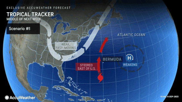
Two scenarios for the long-range movement of Hurricane Lee. |
If the jet stream swings eastward along the Atlantic coast at a swift pace, it should help to protect all of the East Coast from feeling direct rain and high winds from Lee. In this scenario, Bermuda may endure more direct impacts instead.
However, if the jet stream is stronger, dips southward and stalls when Lee approaches, the powerful storm could be pulled in close to the U.S. by steering winds during the middle and latter part of next week.
"Right now, the area in the United States that really needs to pay attention includes locations from the upper part of the mid-Atlantic coast to New England," Rayno said, adding that parts of Atlantic Canada are most likely also get direct impacts from Lee late next week.
Even though Lee is forecast to lose wind intensity as it moves northward out of the very warm water in the southern Atlantic, the storm can still be impactful, with heavy rain, gusty winds and storm surge.
 |
Category 5 Hurricane Lee late on Sept. 7, 2023. |
AccuWeather meteorologists urge residents along the East Coast to take the advanced warning time to prepare for a tropical impact, including having a preparedness kit packed and a reliable way to receive watches, warnings and updates throughout the storm.
On Monday, AccuWeather became the first source to issue a forecast track map as a tropical wave pushed across the central tropical Atlantic. It later became Tropical Depression 13 as it moved over warm waters on Tuesday morning. At 5 p.m. EDT Tuesday, the National Hurricane Center named the system Tropical Storm Lee, which it upgraded to a hurricane at 5 p.m. EDT Wednesday.
Elsewhere in the Atlantic, Tropical Depression Fourteen formed near a group of islands off the west coast of Africa called the Cabo Verde Islands on Thursday midday and, hours later, was upgraded to Tropical Storm Margot.
 |
Margot is likely to ramp up to a hurricane before the start of next week. Once this system moves away from the Cabo Verde Islands, it is not likely to be a threat to land in the near future.
Want next-level safety, ad-free? Unlock advanced, hyperlocal severe weather alerts when you subscribe to Premium+ on the AccuWeather app. AccuWeather Alerts™ are prompted by our expert meteorologists who monitor and analyze dangerous weather risks 24/7 to keep you and your family safer.
