Northern Ontario is hotter than Florida, claiming Canada’s hot spot
If you’re looking for bright sunshine and summery temperatures, pack your sunscreen and hop the next flight to Moosonee.
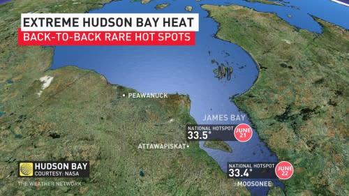
A firm ridge of high pressure parked over northern Ontario made the sunny shores of James Bay the national hotspot two days in a row this week. It’s not exactly a dry heat, either, which makes this rare spell of early summer warmth even more uncomfortable for the region.
DON’T MISS: Living in an Earthship, this Ontario couple inspired others to build their own
Thermometers in Moosonee registered a balmy 33.4°C on Thursday afternoon, making it the hottest town in Canada on June 22. That high is more than 10 degrees above seasonal for the first full day of summer.
Thursday’s high in northern Ontario was also hotter than the afternoon high in most of Florida’s major cities, including Miami, Tampa, Orlando, and Key West, though it was muggier in the Sunshine State than it was in Moosonee.
Despite the difference, there certainly is a touch of humidity in the air to accentuate the warmth up north. Moosonee’s afternoon dew point value registered around 16°C on Thursday. A dew point that high represents enough moisture for anyone to break a sweat beneath the toasty afternoon sun.
Humidex values in the area approached 40 at times on Thursday—a formidable reading for anywhere in Canada, let alone communities way up north.
The staying power of the ridge made this heat a multi-day affair. Wednesday’s national high temperature peaked not far from Moosonee, with Attawapiskat registering an afternoon high of 33.5°C.
Heat warnings issued by Environment and Climate Change Canada (ECCC) continue across northern Ontario for at least one more day.
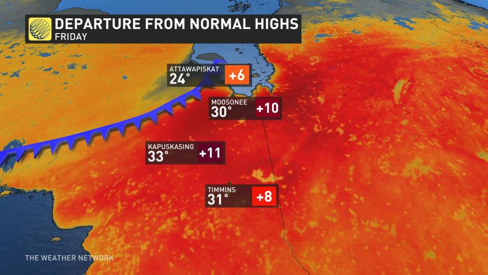
Forecasters expect daytime highs to hit or exceed the 30-degree mark in far northern Ontario again on Friday before a cold front arrives to bump temperatures back down toward seasonal. Thunderstorms are possible across northern Ontario on Friday as the cold front plows into the warm, unstable air parked over the region.
Communities throughout northern sections of Ontario and Quebec will have to closely monitor the potential for wildfire ignition and growth over the next couple of days. This spell of hot temperatures could exacerbate ongoing wildfires and allow additional blazes to spark throughout the region.
WATCH: What a ‘Rex block’ means for your weather
This is northern Ontario’s second stretch of impressive heat so far this season. We saw a similar run of 30-degree readings in Moosonee at the end of May, during which the town came close to breaking its all-time May temperature record.
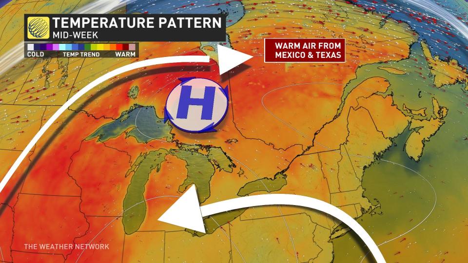
Much like the heat we saw here a month ago, this week’s unusual warmth is the result of a Rex block over the eastern half of North America. This pattern occurs when an upper-level low essentially gets ‘stuck’ south of a ridge of high pressure aloft, jamming up the atmosphere with consistent weather for days on end.
RELATED: Seekers of heat and storms in southern Ontario may be disappointed, again

Folks beneath the ridge generally see calm conditions and unseasonable warmth, while those experiencing the trough see an extended period of cooler and unsettled weather.
Sure enough, that trough is keeping the summer heat away from southern Ontario and casting an unseasonable chill over much of the eastern United States. Charlotte, North Carolina, only hit 22°C beneath a grey sky on Wednesday, which is nearly 10 degrees below seasonal for the city around the summer solstice
This pattern will begin to progress as we head into the weekend, allowing the ridge to break down and finally move east toward the Atlantic provinces. We’ll likely see a trough take its place by next week, allowing cooler-than-seasonal temperatures and periods of rain to return to most of Ontario for the final week of June.

