We now know how much snow Petersburg can expect over the weekend. Here's what NWS says.
PETERSBURG — As much as six inches or more of snow could fall across parts of the Tri-City area this weekend in what weather forecasters are suggesting is a change in the path that the previous two winter storms this month followed.
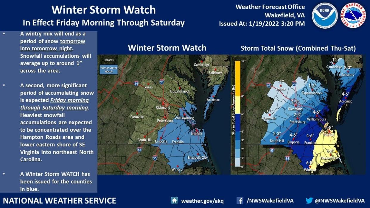
Instead of the northern and Shenandoah Valley parts of Virginia, this storm is expected to stay more south of the Interstate 64 corridor, the National Weather Service office in Wakefield is predicting. Actually, two rounds of precipitation are expected Thursday into Thursday night and again Friday into Saturday. However, NWS says the second storm will bring the larger accumulations.
How much snow you get depends upon where you live in the area.
NWS is projecting anywhere from 2-6 inches of snow to fall in the Tri-City area. Petersburg, Colonial Heights and Hopewell are in the 2-3 inch prediction zone, as are most of Dinwiddie County and parts of northern Prince George County. Most of Prince George and a small sliver of southeastern Dinwiddie are in the 4-6 inch zone.
All of the area will be under a Winter Storm Watch beginning Friday morning.
The closer you move to the coast, the higher the projected snow accumulation. Most of Tidewater could see as much as 6-8 inches of snow, NWS says.
The other two storms that came through this month saw higher totals in areas west and north of the Tri-City area.
So what's the forecast?
The first storm will start as rain before dawn Thursday, then change to a mix of rain and snow in early afternoon and all snow by midday before tapering off Thursday night.
The second storm will bring snow early Friday afternoon, with the majority of the accumulation Friday night and after midnight Saturday. The daylight hours Saturday will see a slight chance of more snow.
High temperatures Thursday will reach the lower 40s Thursday before diving into the 20s by nightfall. Friday, the mercury will struggle to reach the upper 20s.
Wind gusts of up to 24 mph are expected with the second storm, NWS says.
NWS believes Thursday's snow accumulation will be between 1-1.5 inches. By the time Friday night arrives with the highest chance for snow, an additional 1-3 inches are expected.
Click here to see the official National Weather Service forecast for the Tri-City area.
Looking ahead to next week, NWS predicts clearing skies and highs in the 40s MOnday and Tuesday before falling back below freezing Wednesday.
Homeless needs: For nearly two years, the city thwarted efforts to open a shelter
School face coverings: New Virginia governor wants to rescind mask mandates for schools. What does he want done?
Bill Atkinson (he/him/his) is daily news coach for USA TODAY's Southeast Region-Unified Central, which includes Virginia, West Virginia and central North Carolina. He is based in Petersburg, Virginia. Reach him at batkinson@progress-index.com.
This article originally appeared on The Progress-Index: Central, SE Virginia will see fairly significant snowfall this weekend

