Lower chances for heavy snow this weekend in Louisville, but wet weather in store next week
Accumulating snow could be in the forecast for Louisville early Saturday morning, according to the latest predictions from the National Weather Service in Louisville.
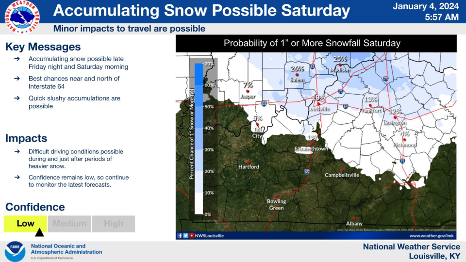
Weather service officials said Thursday morning there is a 13% chance the Louisville metro area receives at least one or more inches of snow. Officials had predicted a 45% chance of at least one inch of snow Wednesday afternoon.
Meteorologist Evan Webb said the weather service changed its prediction because there is "low confidence" in what the weekend storm system will bring. The greatest snow chances remained north of Interstate 64, which includes part of the Louisville metro area.
"It's likely we see snow fall, but how much of it is uncertain at this time," Webb said.
If temperatures at the surface are above freezing, the storm may only bring rain, Webb said. Any snow accumulation would likely melt quickly, as temperatures are expected to get up into the 40s.
"A lot can still change. We could see a slushy rain-snow mix that develops late Friday into early Saturday," Webb said.
There is a chance some brief, moderate-to-heavy bursts of snow could make roads slick Saturday morning, Webb said.
The weather service forecast a 90% chance of precipitation Friday night and a 70% chance of precipitation Saturday, regardless of whether it is snow or rain.
Another storm on the way next week
It probably will not be snow, but a strong storm system could come to Louisville on Tuesday. Webb said the storm could bring "widespread moderate rain" with wind gusts of up to 40 miles per hour.
"It shouldn't bring any significant flooding, but it will provide some much needed drought relief," Webb said. "We could issue a wind advisory."
What's the weather like this week in Louisville?
Friday, Jan. 5: High of 43, low of 35. Expect partly sunny skies.
Saturday, Jan. 6: High of 40, low of 37. Expect rain and snow showers before midnight and snow showers after midnight, with 1 inch of snow accumulation possible.
Sunday, Jan. 7: High of 39, low of 28. Expect cloudy day with a chance of light rain.
Louisville weather radar, predictions
Reach reporter Leo Bertucci at lbertucci@gannett.com or @leober2chee on X, formerly known as Twitter


This article originally appeared on Louisville Courier Journal: Weather in Louisville: Lower chances for snow, rain to come next week

