NWS issues excessive heat warning for Sioux Falls, parts of southeastern South Dakota
Sioux Falls and parts of eastern South Dakota have been baking under severe to extreme heat this week, and the National Weather Service in Sioux Falls warns Thursday is expected to be no different.
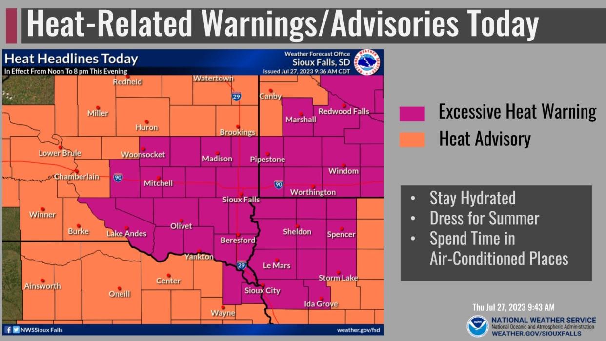
The NWS issued an excessive heat warning at 8:55 a.m. this morning for portions of south central and southeast South Dakota.
Heat index values up to 110 degrees Fahrenheit are expected to bring dangerously hot conditions from noon to 8 p.m. to Sioux Falls and the surrounding region.
A separate heat advisory has also been issued for Beadle, Brookings, Brule, Gregory, Jerauld and Kingsbury counties. Heat indices up to 105 degrees are also expected to bring hot temperatures during the same timeframe Thursday for those areas.
Hot and humid today with afternoon heat indices of 100 to 105 degrees. Temperatures then trend downward for Friday with a possibility of a few storms. More significant cooling takes place for the weekend. pic.twitter.com/GVs5kcz2s8
— NWS Sioux Falls (@NWSSiouxFalls) July 27, 2023
The NWS in Sioux Falls tweeted Thursday morning temperatures are projected to trend downward Friday with the possibility of a few storms, while the area will cool even more significantly during the weekend.
The weather service warned the risk of heat-related illnesses will significantly rise during the warning, particularly for people working outdoors. People are advised to drink plenty of fluids and stay out of the heat as best they can.
The agency also said children, pets and the elderly should be checked on during this period. Kids and animals should not be left in vehicles under any circumstance.
More: Could temps hit 100 degrees Wednesday? Sioux Falls under heat advisory this afternoon
A look at the heat throughout the week
Here's a look at the forecast over the next several days, according to the NWS Sioux Falls website:
Today: Mostly sunny and hot, with a high near 99. Heat index values as high as 109. South southwest wind 10 to 15 mph, with gusts as high as 20 mph.
Tonight: Mostly clear, with a low around 72. South wind 5 to 10 mph becoming northeast after midnight.
Friday: A slight chance of showers and thunderstorms after 4 p.m. Mostly sunny, with a high near 91. Northeast wind 10 to 15 mph. Chance of precipitation is 20%.
Friday Night: A slight chance of showers and thunderstorms before 7 p.m. Mostly clear, with a low around 65. North northeast wind around 15 mph, with gusts as high as 20 mph. Chance of precipitation is 10%.
Saturday: Sunny, with a high near 85. Northeast wind around 10 mph.
Saturday Night: Mostly clear, with a low around 62. East wind around 10 mph.
Sunday: Mostly sunny, with a high near 86.
Sunday Night: A chance of showers and thunderstorms after 1am. Partly cloudy, with a low around 65. Chance of precipitation is 30%.
Monday: Mostly sunny, with a high near 88.
Monday Night: Partly cloudy, with a low around 67.
Tuesday: Partly sunny, with a high near 90.
Tuesday Night: Partly cloudy, with a low around 67.
Wednesday: Mostly sunny, with a high near 90.
This article originally appeared on Sioux Falls Argus Leader: NWS issues heat warning for Sioux Falls, parts of southeastern SD

