Offshore wind companies may want to reduce marine sanctuary off California’s Central Coast
Three companies planning to deploy hundreds of floating wind turbines in the Pacific Ocean off San Luis Obispo County’s coast are concerned about size and boundaries of the proposed Chumash Heritage National Marine Sanctuary, which they say could impede their projects’ success.
Of top concern are the unclear regulations Equinor, Invenergy and Golden State Wind may have to follow to put cables running from their turbines through the proposed marine sanctuary to onshore electricity grid connections.
The proposed marine sanctuary “framework would subject leaseholders to an unacceptable level of regulatory, economic and management risk at a time when getting more renewable energy online in California is of the utmost importance,” the companies wrote in a joint letter to the National Oceanic and Atmospheric Administration on Oct. 25.
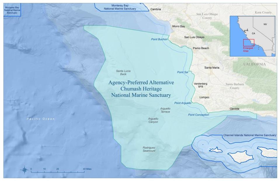
The Chumash Heritage National Marine Sanctuary is proposed to encompass 5,617 square miles of the Pacific Ocean from Hazard Canyon Reef south of Morro Bay to an area just north of Goleta in Santa Barbara County.
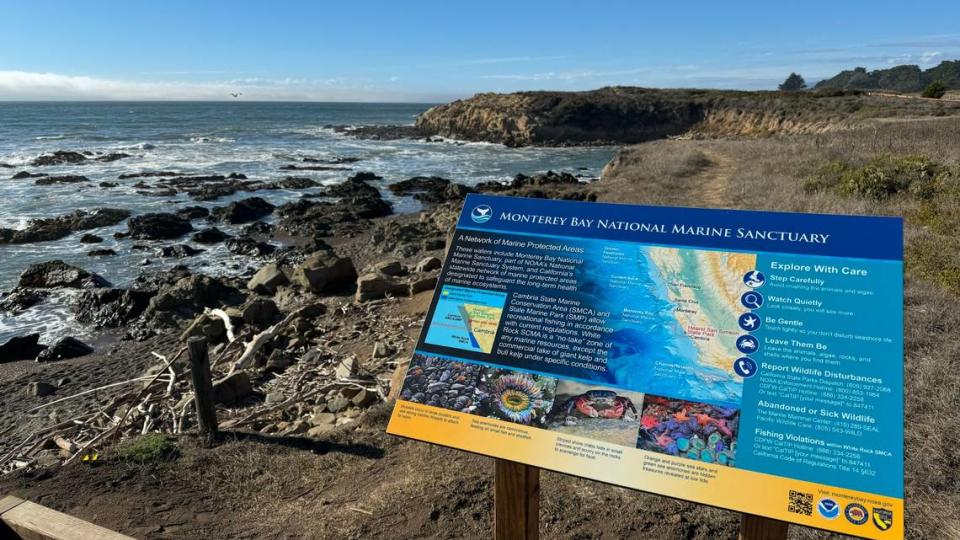
Advocates, on the other hand, have written thousands of public comment letters to NOAA requesting the northern boundary be extended to Cambria to connect with the Monterey Bay National Marine Sanctuary.
“Offshore wind renewable energy generation in the lease areas is compatible with and complementary to the NOAA ... mission through (the marine sanctuary) to promote marine conservation and reduce the impacts of climate change,” the companies wrote in the Oct. 25 letter.
But the proposed sanctuary regulations, as laid out in draft designation documents released on Aug. 24, “would increase technical and regulatory risk in a manner that could impede development of offshore wind on the Central California Coast,” the companies wrote.
In the letter by the offshore wind companies, they asked that the agency establish clearer regulations for laying the cables, and perhaps redraw the northern boundary of the marine sanctuary.
Marine sanctuary boundary could be moved to avoid overlap with subsea cables, companies say
Shifting the northern boundary of the sanctuary slightly south would allow the companies to lay cables from the offshore wind development to onshore grid connections at the Morro Bay and Diablo Canyon power plants without needing to go through the marine sanctuary.
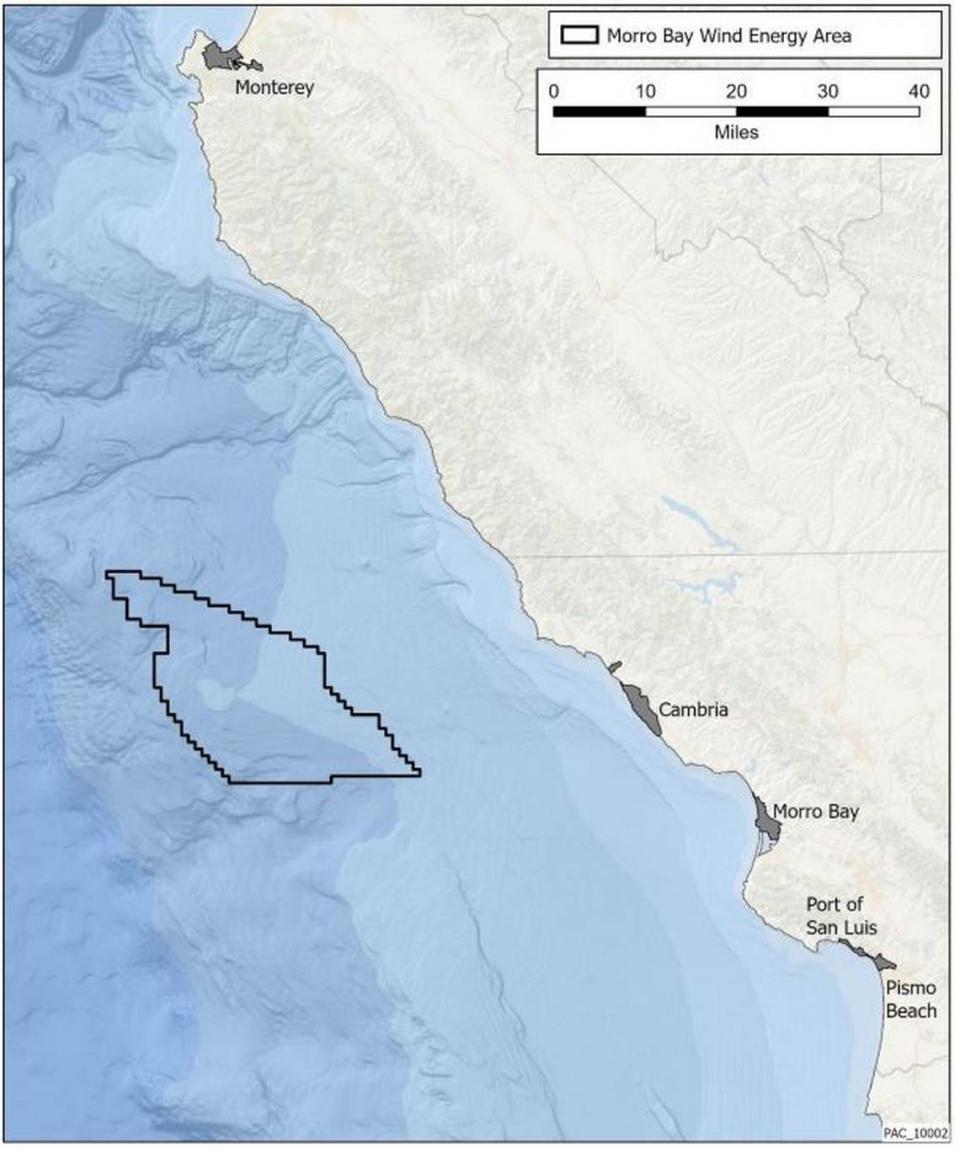
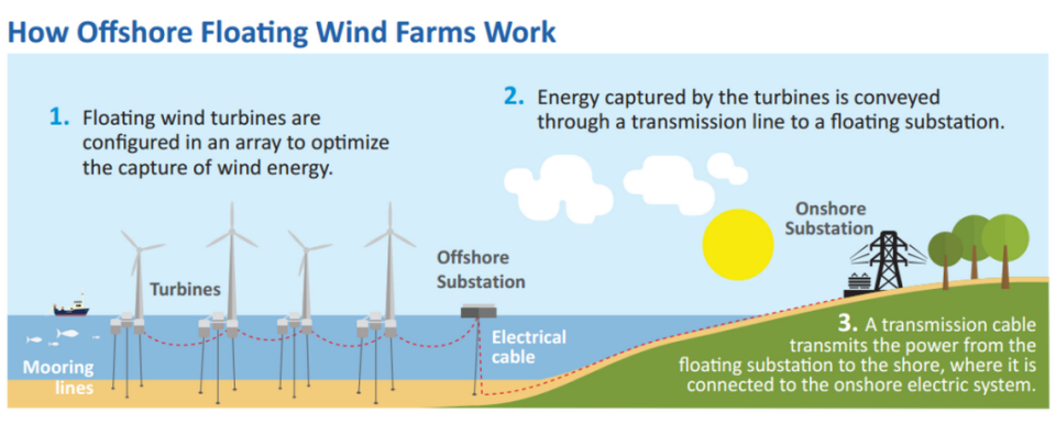
The wind companies are expected to develop a 376-square-mile area of the Pacific Ocean about 20 miles off the coast of Cambria and San Simeon with floating wind turbines. The area could be developed with hundreds of 1,000-foot-tall turbines to generate at least 6 gigawatts of electricity to power 4.5 million homes.
Such development will likely require several underwater cables to bring the electricity from the turbines into the grid.
The cables will need to be spaced about “three times the water depth” away from each other to meet industry standards, the companies wrote in their letter to NOAA. The water where the turbines are proposed is about 900 meters deep.
“Given the large number of export cables currently anticipated, the area left open in (NOAA’s proposed marine sanctuary boundary) does not provide sufficient space to accommodate those export cables given technical requirements and potential constraints,” the Oct. 25 letter said.
Adjusting the marine sanctuary’s boundaries to extend to around Port San Luis would likely give the companies the needed space to lay down the cables.
“It is imperative that leaseholders can retain flexibility in siting submarine cables to minimize impacts to resources, existing uses and marine users of the area while also considering technical considerations,” the letter said.
Smaller marine sanctuary could be potential solution
However, the companies are adamant in the letter that the adjusted marine sanctuary boundary could be temporary.
“The leaseholders support potential opportunities for future expansion of the sanctuary once there is more certainty as to the precise location and future operational needs of the submarine cables,” the letter said.
The companies referred to the Flower Garden Banks National Marine Sanctuary in the Gulf of Mexico as an example of a sanctuary that was expanded after first established. Flower Garden Banks was established in 1991 covering 56 square miles and expanded in 2021 to encompass 160 square miles.
This expansion allowed for the greater protection of reef ecosystems in an area popular for its offshore oil development.
Equinor, Invenergy and Golden State Wind said in their Oct. 25 joint letter that the companies would endorse a process where — if NOAA were to draw the Chumash Heritage National Marine Sanctuary’s northern boundary at Port San Luis — the boundary could be shifted north after the offshore wind cables were sited.
“By utilizing this framework ... NOAA can thoughtfully balance the interests of all ocean users and the (sanctuary) conservation priorities at a time when more is known about the placement of offshore wind facilities and offshore wind’s interactions with the ocean environment,” the Oct. 25 letter said.
Companies want clearer regulations to minimize risk of offshore wind energy development
Regardless of where the marine sanctuary boundaries are drawn, the offshore wind companies in their letter call for clarity on the regulations regarding the development of the subsea cables connecting the turbine development to onshore grid terminals.
The 376-square-mile area of the ocean slated for development is leased to the three companies by the U.S. Bureau of Ocean Energy Management. The federal agency has leased the area to the companies for 33 years.
In its draft regulations for the proposed sanctuary, NOAA “has not articulated a particular plan of action that explicitly allows for offshore wind cables to pass through” the sanctuary, the companies wrote in their letter. Instead, the draft regulations describe a “potential pathway” for the cables, the letter said.
“Based on the numerous uncertainties as to where export cables will be routed and the fact that both Diablo Canyon and Morro Bay are important interconnection points, a clear regulatory pathway is imperative no matter the boundaries of the sanctuary that is ultimately adopted,” the companies wrote.
In its draft regulations, NOAA proposed that the offshore wind companies could obtain five-year special use permits to allow for the “continued presence” of cables through the marine sanctuary. That short term is a particular concern for the companies due to the uncertainty it could cause for the wind turbine developments.
“The assertion that permit terms may provide for a ‘seamless’ renewal process as long as the permittee remains in compliance is of little comfort as there are no clear terms and conditions of these potential (special use permits) set forth in the proposed regulations,” the companies wrote in the Oct. 25 letter. “Such uncertainty could adversely impact the ultimate ability of the projects to obtain the billions of dollars in financing that is needed for such major infrastructure projects.”
NOAA is expected to release the final designation documents for the proposed marine sanctuary in 2024.

