One Atlantic storm moves ashore, 4 others jockey over the ocean. What’s expected in NC?
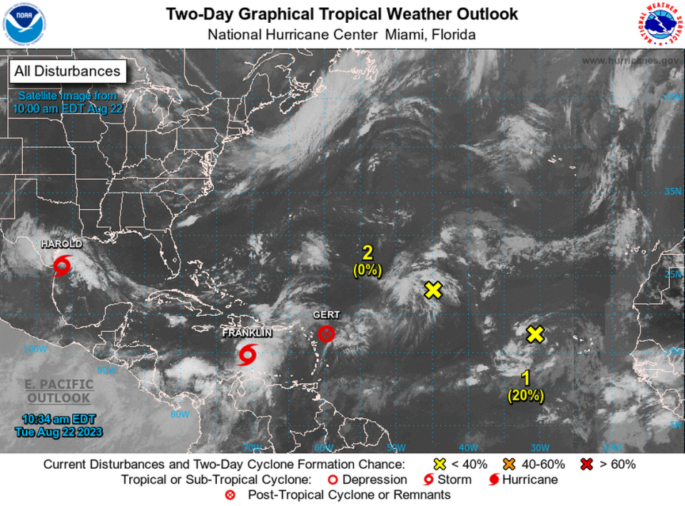

Four weather disturbances continued to move slowly around the Atlantic on Tuesday, while one storm moved ashore bringing 45 mph winds and heavy rain to south Texas and northern Mexico, NOAA said.
The Gulf system became Tropical Storm Harold early Tuesday, NOAA said, and strengthened through the morning, gathering winds of 50 mph.
The storm came ashore around 11 a.m. at Padre Island, Texas, and is expected to move across south Texas and northern Mexico through early Wednesday, bringing 3 to 5 inches of rain to the area, with up to 7 inches in isolated spots.
Though some Gulf storms have been known to affect weather in the Southeast, including the North Carolina mountains, Harold is expected to track west over Texas and not have an effect here.
However, forecasters continue to watch four other systems in the Atlantic.
The most immediate concern: Franklin
Tropical Storm Franklin was churning in place in the Caribbean on Tuesday south of the Dominican Republic. NOAA forecasters said the storm likely would make a sharp turn to the north on Tuesday. It’s expected to strengthen some before coming ashore Wednesday on Hispaniola, bringing up to 10 inches of rain to the Dominican Republic and Haiti as well as portions of Puerto Rico. Up to 15 inches of rain could fall in isolated areas, according to NOAA.
Forecasters are especially concerned about mudslides in Haiti as a result of such heavy rain. The Associated Press has reported that more than 200,000 people in Haiti are displaced because of gang violence in the nation
Once Franklin crosses Hispaniola on Wednesday, NOAA said, the storm could strengthen as it moves back into the Atlantic. As of Tuesday, NOAA predicted the storm would then head north-northeast, away from the U.S. Atlantic coast, but could jog back to the north-northwest Saturday and Saturday night.
Jim Cantore on the lookout
Weather Channel meteorologist Jim Cantore mentioned Franklin in a post on platform X Tuesday. “Franklin will have to be watched over Hispaniola for dangerous flooding then potential rapid development with at least a motion back toward the USA next week as a hurricane, maybe major,” Cantore said.
Other systems on the radar
▪ Gert, with 35 mph winds, was downgraded Tuesday morning to a remnant, and NOAA said the system is no longer a concern.
▪ Emily — or, the remnants of Emily, after it was downgraded from a tropical storm — remains in the central tropical Atlantic. NOAA said Tuesday it was unlikely that the system would redevelop into a tropical storm over the next couple of days, but that as it moves westward across the Atlantic, it could rebuild late in the week or over the weekend.
▪ A system in the eastern tropical Atlantic was producing rain and thunderstorms several hundred miles west of the Cabo Verde Islands on Tuesday, NOAA said. As the disturbance moves west-northwest over the Atlantic, it could develop into a tropical storm late this week or over the weekend, forecasters said.
The next storms names for the current Atlantic hurricane season are Idalia and Jose.