"One of the biggest psychological operations": Ukrainian finds in Europe tens of maps with Crimea labelled as Russian or belonging to no one
A Ukrainian, Mykola Holubei, found tens of political maps, where the borders of Ukraine are shown incorrectly, in European shops.
The inaccuracies concern the status of Crimea and other territories temporarily occupied by Russia.
Holubei, who currently resides in Germany, told Ukrainska Pravda.Zhyttia that everything began when he decided to buy a big wall map.
"I’ve loved maps since childhood so I decided to get myself a New Year present. I bought a map and planned to make a collage of good memories of this year. Yet I notice that Crimea on the map is marked not as a part of Ukraine but as a disputed territory," Holubei explains.
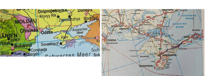
A state border is drawn between Ukraine and Crimea, and the peninsula is marked as Russian territory
This appalled him, and he published the photo of the map on social media. What especially struck him was the fact that the map was sold in a huge German chain of shops.
Later Holubei went to the shop again and bought five more maps. It turned out that the information about the territory of Ukraine in four of them is incorrect and contradicts the official UN and EU information about Ukraine.
After that, Holubei and his "agents" combed through 20 book stores in Germany, as well as in Austria and Switzerland. The "mistakes" in the maps bought there concerned not only Crimea but also other territories captured by Russia from 2014 to 2022.
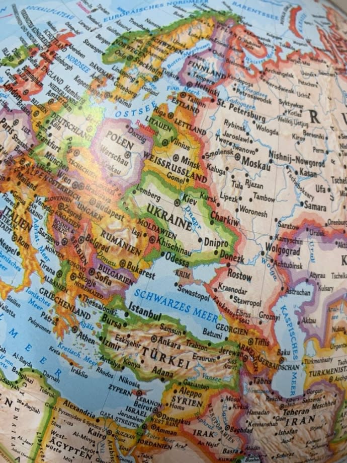
Holubei states that falsified data about the territory of Ukraine can be found in driver’s atlases, on globes and other maps for adults and children, particularly for schoolchildren. Holubei also noticed that the maps posted on the Internet are politically correct, unlike those sold in the stores.
There were so many incorrect markings on the maps bought in the European bookstores that Holubei created his own classification of them in his research.
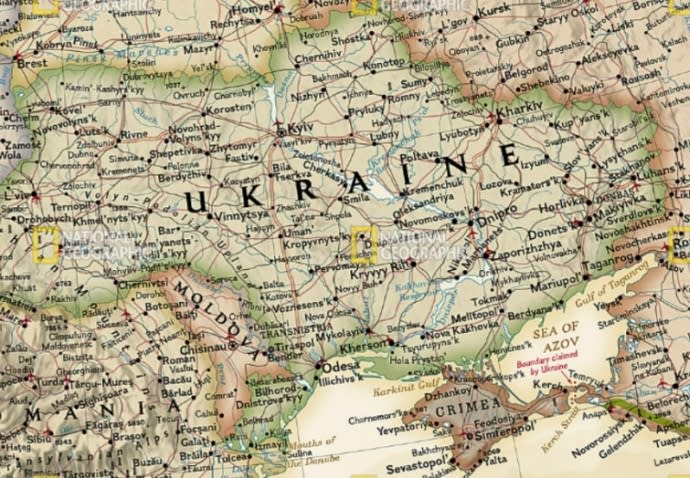
How Crimea and other Ukrainian territories are shown on the maps in Europe
On some maps, the state border between Ukraine and Crimea is depicted as a dotted line. On others, Crimea is attributed to Russia, either partially or completely.
Some even state that "Crimea is the territory of Russia, which is claimed by Ukraine".
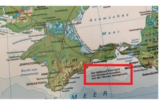
Crimea is depicted as a territory of the Russian Federation "claimed by Ukraine"
Holubei also found a map where Crimea was "separated" from Ukraine, and Isthmus of Perekop, its part, was "integrated" into the territory of Russia.
On National Geographic maps, which also include images of Ukraine not within the 1991 borders, one can see Crimea, which is coloured differently from the rest of Ukraine, as well as "independent" Crimea, which does not belong to any country.
The maps also sometimes depict the so-called "LPR" and "DPR" [self-proclaimed and non-recognised Donetsk People’s Republic and Luhansk People’s Republic – ed.] and question the state border in Donetsk and Luhansk oblasts.
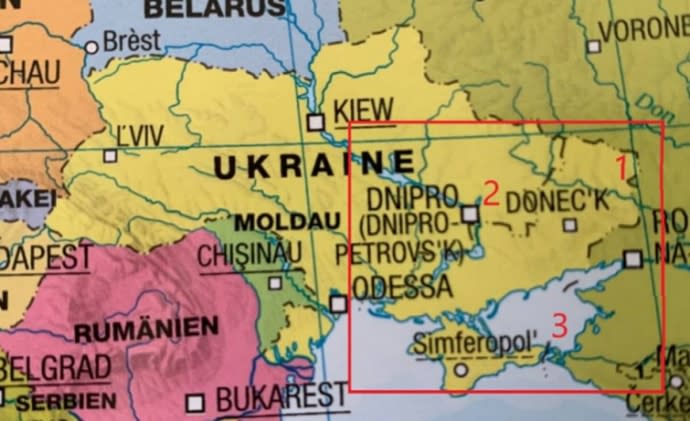
The maps even show Ukraine, which has been "deprived" of the territories temporarily captured by the Russian Federation since February 2022, namely parts of Zaporizhzhia, Kherson, Donetsk and Luhansk oblasts.
Crimea also "changes" its affiliation on Google Maps, depending on the country from which you access it. If you do it from Ukraine, Google displays an image where there are no borders between the country and Crimea. But there is a clear border between Crimea and Russia.
The territories of the so-called LDPR are distinguished on the territory of Ukraine
However, if you make a query from Germany or Kazakhstan, Google displays an image with a dashed line between Ukraine and Crimea. The same line is shown between Crimea and Russia.
The state border between Ukraine and the Russian Federation in Donetsk and Luhansk oblasts is being questioned
"My first reaction was surprise. For me, the borders of Ukraine since 1991 have been part of my identity as a Ukrainian. One of my hypotheses is that this trend is one of the biggest PSYOPs [psychological operations – ed.] against Ukraine. In ancient times, rock paintings were a form of transferring information.
Lavrov says that Russia has never attacked anyone, but only defended itself. So for me, the maps that say that Crimea is Russian territory claimed by Ukraine are a graphic reflection of Lavrov's position," Mykola Holubei says.
What to do about the situation and what the European publishers say
Now Mykola has an action plan. Mykola Holubei has contacted the Ministry of Foreign Affairs of Ukraine, created his own Telegram channel and is attracting the attention of European media.
Mykola has also decided to file lawsuits against companies that produce and sell incorrect maps.
Crimea is shown with the borders of Ukraine, but has a different fill colour than Ukraine
The Austrian publishing house Freytag-Berndt, which depicted Crimea as a "disputed territory" in response to a request from LIGA.net, has said that they are trying to "create an image of the world that should be as realistic as possible, and therefore the conflict zones are depicted as ‘disputed’."
According to the publishers, "it has been impossible to show the correct contact lines" since the beginning of the full-scale Russian invasion.
"When there is enough space, we add the inscription ‘occupied by Russia’ in the text under Crimea. There may still be older maps with ‘disputed territories’ on the market, but all new maps show Ukraine's borders in accordance with international law," Freytag-Berndt states.
Crimea, which is an integral part of Ukraine, is portrayed as part of the Russian Federation
Nevertheless, according to Mykola Holubei, he has been researching how "disputed" territories in other countries are depicted on maps.
"Neither Western Sahara in North Africa, nor Nagorno-Karabakh, which is being fought over by Armenia and Azerbaijan, nor Kashmir on the Hindustan Peninsula are labelled as 'disputed territories' on most maps," Mykola says.
Journalists fight on their own frontline. Support Ukrainska Pravda or become our patron!

