Evacuation ordered ahead of possible mud, debris flows in San Bernardino County
The remnants of Tropical Storm Kay brought flash flooding to parts of Southern California as mud and debris flows careened into three San Bernardino County communities Monday.
Some residents of Oak Glen were ordered to evacuate just after 9 p.m. Monday as officials cited "a potential for mud and debris flow," according to the San Bernardino County Sheriff's Department.
The order covers those living north and south of Oak Glen Road from Casa Blanca Road to the county line, and south from Wild Lilac Point to Wildwood Canyon, deputies said. The number of Oak Glen residents ordered to evacuate was not available Monday night.
An evacuation center has been set up at Redlands East Valley High School, 31000 E. Colton Ave. in Redlands.
Forest Falls residents were ordered to shelter in place, deputies said.
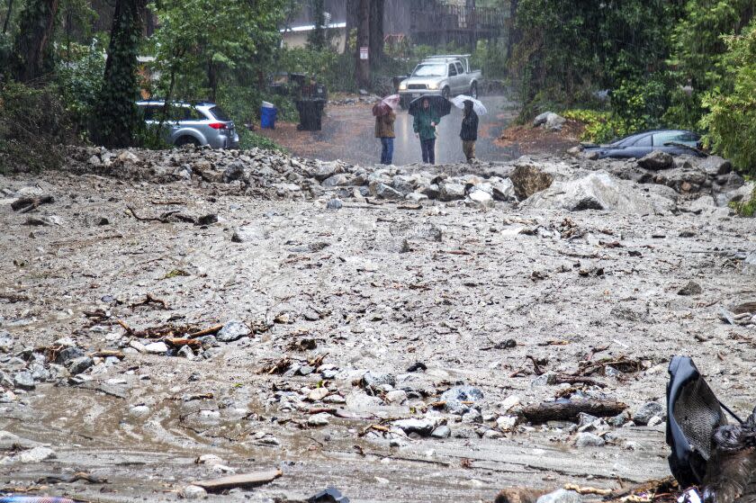
The orders came after mudslides and debris flows slammed into Forest Falls on Monday afternoon.
More than 40 firefighters were conducting a street-by-street search and damage assessment Monday night, according to the San Bernardino County Fire Protection District.
"Crews are finding downed power lines, leaking propane tanks [and] structural damage to multiple structures," firefighters said. "Roads are covered with multiple feet of mud and debris."
An estimate on the number of structures affected was not available Monday night.
The California Department of Transportation and county crews were working to clear the roads, firefighters said. No injuries had been reported.
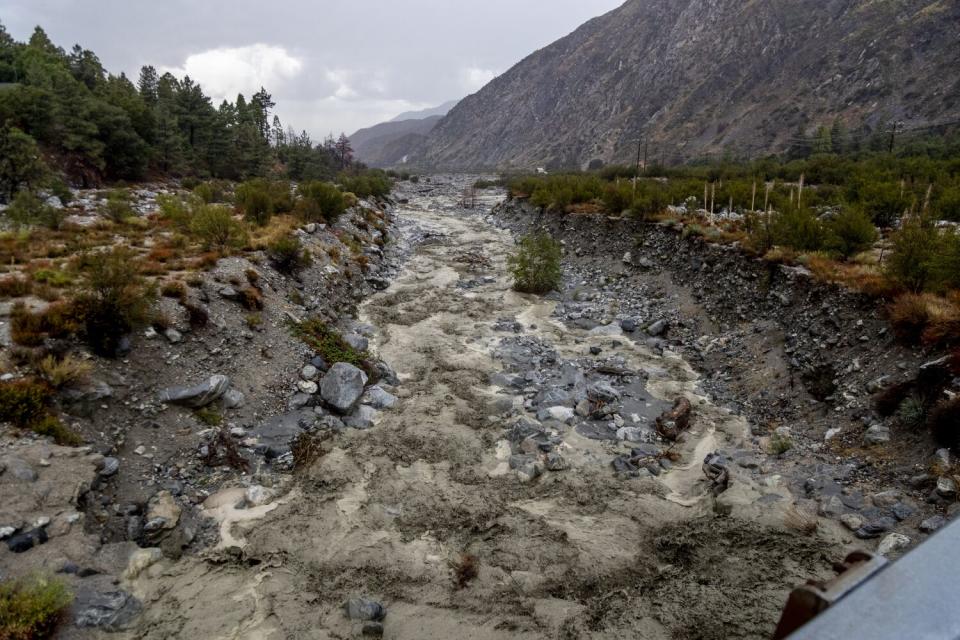
Although rain was "expected to taper off," fire officials were concerned about mud and debris flows throughout the night because of how much rain had fallen over the course of two days.
The mud and debris flows were the latest in a series of continuing effects from the now-diminished storm.
“We have one more day to get through as far as some potential for serious flooding, and then after that we should be home free,” Dave Bruno, a National Weather Service meteorologist in Oxnard, said Monday.
Thunderstorms had developed in the foothills of the Antelope Valley early Monday afternoon, and more storms were expected for other areas in Los Angeles and Ventura counties. Storms were expected to be slow and produce heavy downpours.
The weather service predicted about a 40% chance of rain in Hemet, where the Fairview fire exploded last week. The fire had burned 28,307 acres as of Monday morning and was 53% contained, according to an incident report from the California Department of Forestry and Fire Protection and the Riverside County Fire Department. Much-needed precipitation from Tropical Storm Kay, which churned off the Southern California coast last week, helped slow the fire's spread but also created some challenges.
At an operational briefing Monday morning, Justin McGough, the Fairview fire day operations branch chief for Cal Fire, said rain started about 2 p.m. Sunday, including heavy rain over Gibbel Flats, Avery Canyon and in the Batista Canyon area, with flooding and mudslides covering roads in those areas, hindering some firefighting efforts for about four hours until roads reopened. One home had minor flooding and damage to the garage, McGough said.
At the end of a wild weather week for Southern California, a satellite image offered an unusual sight: a huge tropical cyclone swirling over the Southland.
The satellite image, captured Saturday by the National Oceanic and Atmospheric Administration's Geostationary Operational Environmental Satellite, showed Tropical Storm Kay hovering off the coast of Southern California and Mexico's Baja California Peninsula.
Though Kay never made landfall in the state, "it was certainly closer than anything we've ever had before that I can remember," said Mike Wofford, a meteorologist with the National Weather Service in Oxnard.
Wofford said it would take some time for officials to analyze the full scope of the storm, including its ultimate size and cumulative effects. But Brandt Maxwell, a weather service meteorologist in San Diego, said "it's not outlandish to say that the impacts covered a 1,000-mile-wide area."
Rain lashed Southern California on Sunday, setting precipitation records and leading to dangerous road conditions and flood damage. Cal State San Bernardino's campuses in San Bernardino and Palm Desert were closed Monday because of extensive flood damage, though essential staff members were called in to work. The university is expected to reopen Tuesday.
Around 9:30 p.m. Sunday, 21 cars became trapped in a mudslide in the Lake Hughes area. Los Angeles County firefighters and California Highway Patrol officers rescued 51 people, including some by helicopter. Another person was rescued about 11 p.m., said Sheila Kelliher-Berkoh, public information officer for the L.A. County Fire Department.
"That mud came up really fast up around the headlights, and so they all kind of needed help out of their vehicles," Kelliher-Berkoh said.
Only one person was injured, and it was minor, she said.
As of 3 a.m. Monday, Elizabeth Lake Road from Johnson Road to Pine Canyon as well as Lake Hughes Road were blocked because of mudslides, said CHP Officer Peter Nicholson. Cleanup efforts were underway, but no further information was provided on the status of the stalled cars.
All roads were open Monday morning in San Bernardino, said Tirrell Hayes, a CHP officer in San Bernardino.
Sandberg saw 0.32 inches of rain Sunday, squeaking past the 1976 record for the date of 0.31 inches. Palmdale doubled its record of rainfall from 0.23 inches in 1976 to 0.46 inches Sunday. Both places are likely to get heavy rain again Monday, Bruno said. Sandberg could break its 1959 record of 0.66 inches, and Palmdale could break its 1963 record of 0.18 inches.
San Jacinto received 0.32 inches of rain Sunday, breaking a 2021 record for the date, and Campo doubled its record set in 2015 to 0.88 inches.
The rest of the week’s weather appears benign and boring, meteorologists said. “We can maybe relax a little bit and get back to our complacent SoCal ways,” said Miguel Miller of the weather service's San Diego office.
This story originally appeared in Los Angeles Times.

