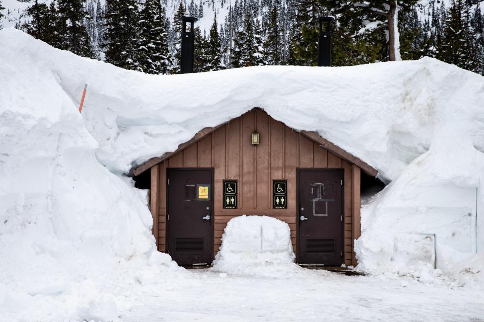
Oregon snowpack jumps to 172% of normal, best since 2008, could delay wildfire season
Oregon's mountain snowpack ballooned to its highest levels since 2008 after a blizzard slammed the Cascade Range with 20 to 30 inches of snow last weekend.
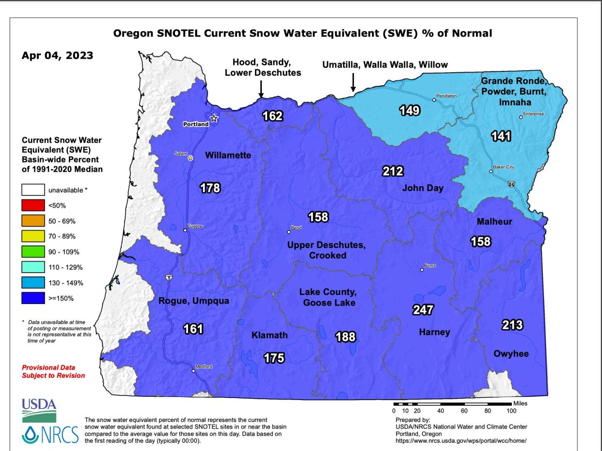
The state's snowpack reached 172% of normal on Tuesday, a metric that takes into account how this year's snow stacks up against the last 30 years. In the Willamette Basin — including the Central Cascades east of Salem — snowpack is 178% of normal.
Oregon had big snow years in 2017 and 2011, but this year has gradually surpassed both in terms of snow following a very cool and wet March and early April.
April 1 is the traditional date of peak mountain snow in Oregon and is considered important because it helps officials project what type of spring and summer the state can expect.
The excess snow should mean reduced wildfire danger in the early summer along with an extended winter recreation season. Much will depend on how quickly the snow melts.
While the amount of snow is way up, Oregon’s precipitation remains below normal, at 95% of normal statewide and 87% of normal in the Willamette Basin, leading to low levels in reservoirs such as Detroit Lake.
Upcoming forecast: cool and wet
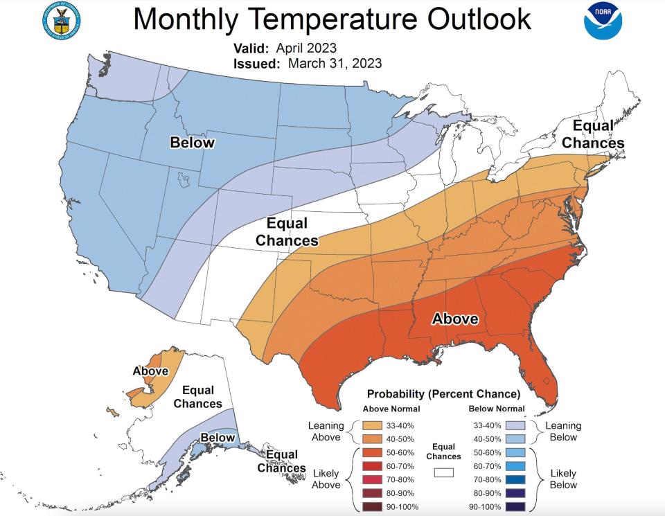
The snow probably isn’t finished with Oregon’s mountains. Oregon is forecast to stay cool and wet during April — likely bringing additional snow — according to the long-term forecasts issued by the National Oceanic and Atmospheric Administration.
Rain is forecast nearly every day in the Willamette Valley this week and next — along with some potential low-elevation snow — although temperatures could rise into the 60s by the weekend.
Long-term forecast: hot and dry
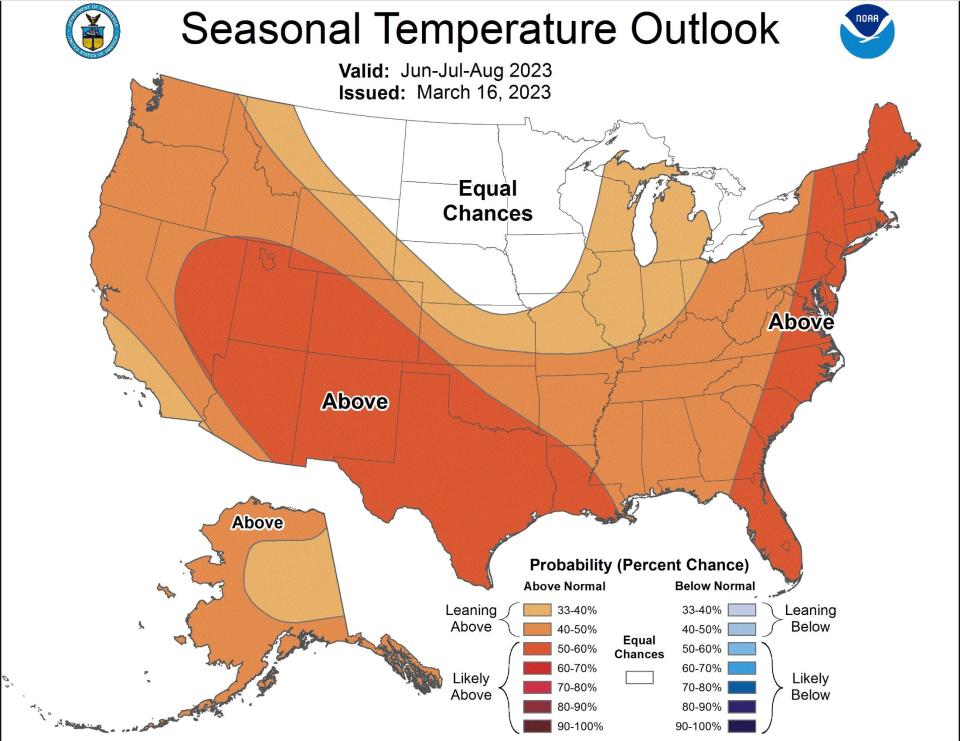
Long-term forecasts are indicating a hot and dry summer, according to NOAA, for June, July and August.
“The very good condition of the snowpack should insulate us to a certain extent against adverse impacts associated with earlier than normal snowmelt,” Oregon State climatologist Larry O’Neill said.
Wildfire projections
A good snowpack doesn’t automatically mean a quiet wildfire season, although it normally does help.
“With this much snow, we don't expect an early start to fire season for most of Oregon above about 4,000 foot elevation,” O’Neill said.
A good snowpack followed by a hotter than normal summer, however, can lead to higher fire danger because grasses and fine fuels to grow rapidly and then dry out.
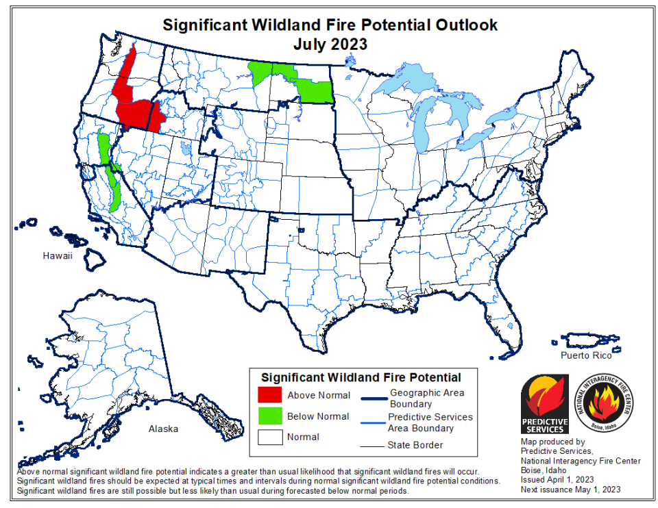
Indeed, the nationwide fire potential forecast puts parts of central and southeast Oregon at “above normal” danger by July.
The rest of the state is projected to remain at normal levels through July.
One of Oregon’s best years for snowpack, 2017, also become one of the state’s worst wildfire seasons after temperatures spiked well above normal in July and August.
Detroit Lake nearly 60 feet below normal
Oregon’s below-average rainfall has kept lower-elevation soils dry and helps explain why some reservoirs, such as Detroit Lake, are way below where they should be for this time of year.
Detroit Lake’s level is currently at 1,481 feet above sea level, while it should be closer to 1,542 feet above sea level. That nearly 60-foot difference will be difficult to make up without a major rainfall or atmospheric river event.
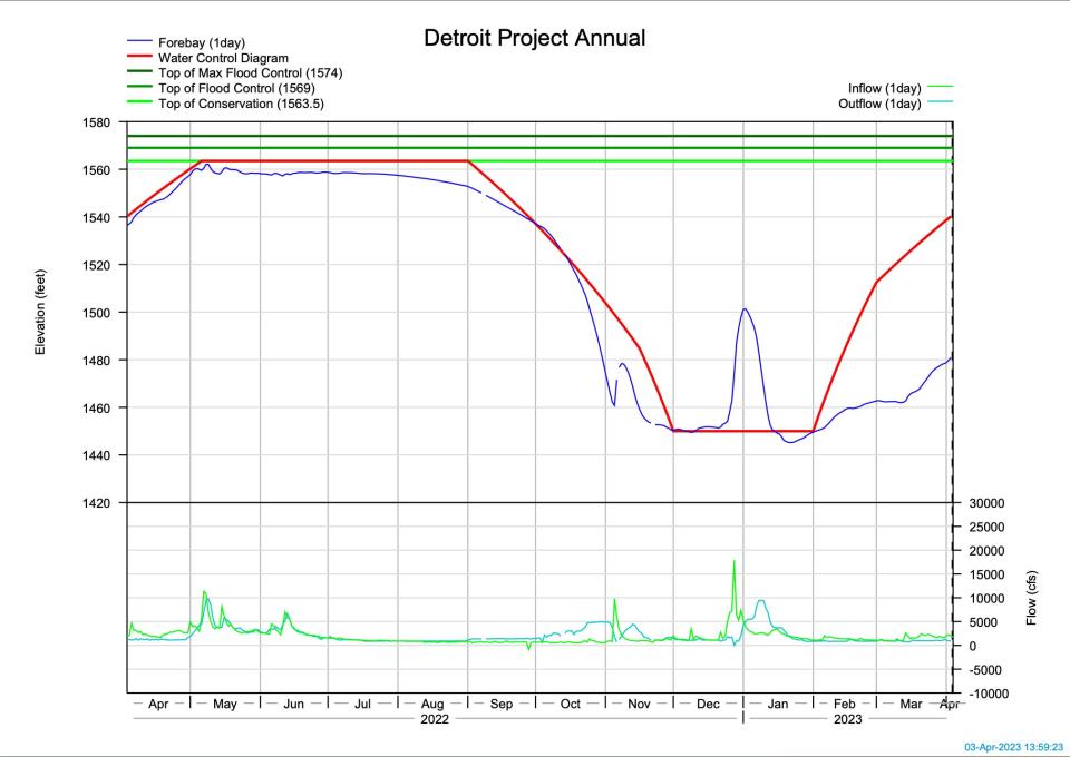
U.S. Army Corps of Engineers, which manages Detroit Lake, said they’ve reduced outflows at Detroit Lake in an effort to boost reservoir levels. But they also need to release water into the North Santiam River for fish and wildlife.
“Precipitation has been lacking everywhere,” U.S. Army Corps of Engineers spokeswoman Kerry Solan said. “The streamflows are low right now. It’s likely because of the soil moisture being inadequate from the last few years of drought. So, the ground is absorbing it instead of making it into the rivers.”
Winter recreation boon
In more positive news, the snowpack should allow for an extended winter recreation season. All of Western Oregon’s ski areas have extended their seasons through the end of April while Mt. Bachelor and Timberline will remain open through May. Sno-parks also will host great places to ski, snowshoe and cross-country ski deep into spring.
Take advantage before El Nino brings warm winter in 2024
This year's excellent snowpack serves as a capstone to Oregon’s third straight La Nina — a weather pattern typically associated with cooler, wetter and snowier conditions in winter and spring in the Northwest.
But there’s a decent chance that could change next year.
Earlier this month, La Nina officially ended and there’s a 60% chance that El Nino, and potentially a strong one, will develop, typically meaning warmer-than-normal winter conditions.
Oregon State University climatologist Larry O’Neill said a strong El Nino, combined with the baseline warming from climate change, could mean a difficult year for those who love snow. He said next fall and winter could be similar to 2015, Oregon’s hottest year in recorded history and a brutal season for winter recreation. Many ski areas couldn’t open for more than a few days, if at all, especially at mid-elevations.
“Get your turns in now,” O’Neill said. “During El Ninos, global temperatures are typically well above normal to begin and since it’s happening during this global warming condition, the concern is that this El Nino will be warmer than ones we’ve experienced in the past."
Not all ski officials are concerned, however, noting those at the highest elevations were still able to operate.
“I’m not concerned at all,” Mt. Hood Meadows spokesman Dave Tragethon said. “We tend to get earlier snow in El Nino years – and the storms tend to be more intense. But we can average just as much snow in El Nino seasons up on the mountain as other times neutral or La Nina."
Zach Urness has been an outdoors reporter in Oregon for 15 years and is host of the Explore Oregon Podcast. To support his work, subscribe to the Statesman Journal. Urness is the author of “Best Hikes with Kids: Oregon” and “Hiking Southern Oregon.” He can be reached at zurness@StatesmanJournal.com or (503) 399-6801. Find him on Twitter at @ZachsORoutdoors.
This article originally appeared on Salem Statesman Journal: Oregon snowpack jumps to 172% of normal, best since 2008

