Oregon wildfire updates: Red flag warning could mean wildfire growth, new fires
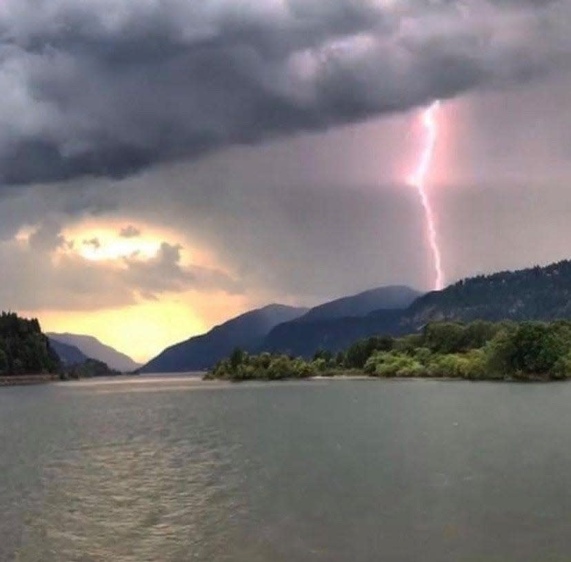
A red flag warning has been issued for the length of the western Oregon Cascade Range and foothills as gusty winds and potential lightning could bring new wildfires or wildfire growth.
The warning, issued by the National Weather Service in Portland, is in place from 11 a.m. Thursday to 11 a.m. Friday.
The fire danger isn’t as extreme as the Labor Day east wind events of 2020 or 2022 — which both saw significant statewide blowups and power outages. But the combination of bone-dry conditions, gusty east winds, low humidity and thunderstorms with “abundant lightning” does trigger a new level of fire danger.
“There’s a chance we could get some beneficial precipitation with the thunderstorms, and it’s not as extreme as the Labor Day 2020 or 2022, but it is a time when people need to be really careful,” said Andy Bryant with the National Weather Service in Portland.
The concern is twofold. First, that local wildfires already burning — Bedrock, Lookout east of Eugene, and the Flat and Smith River Complex in southwest Oregon — could grow. And second, that lightning ignites new fires.
“Conditions may be favorable for rapid fire spread which may threaten life and property. Use extra caution with potential ignition sources, especially in grassy areas,” the warning said. “Outdoor burning is not recommended.”
Here’s the latest on fires burning around Oregon.
Liberty Fire in Salem
For coverage on the Liberty Fire that burned on Wednesday in South Salem, see updates here.
Lookout Fire grows to 14,286 acres, evacuation area expanded
The Lookout Fire in the McKenzie corridor was active on Wednesday and grew to 14,286 acres, up from 13,207 acres the day before. The fire is listed at 6% containment.
The Linn County Sheriff's Office expanded the evacuations on the north side of the fire. A new evacuation map can be found at bit.ly/3KTsCs5
“Firefighters and heavy equipment contained several spot fires across Deer Creek Road on the fire’s northeast flank. As the main fire progresses to the southeast toward Highway 126, firing operations are being utilized to ‘stay ahead’ of the main fire as it backs down the slope,” a Thursday morning update said. “Critical fire weather is possible today with a chance of thunderstorms this evening.”
A shelter remains in place at Westridge Middle School in Oakridge for evacuees and small pets from the Bedrock and Lookout fires. A large animal shelter is set up at the Lane County Fairgrounds in Eugene.
The most recent evacuation warnings can be found at bit.ly/3EaghvI. A map showing the public land closure around the fire can be found at bit.ly/3QPvw4Y.
Smith River Complex again shows significant growth, up to 52,563 acres
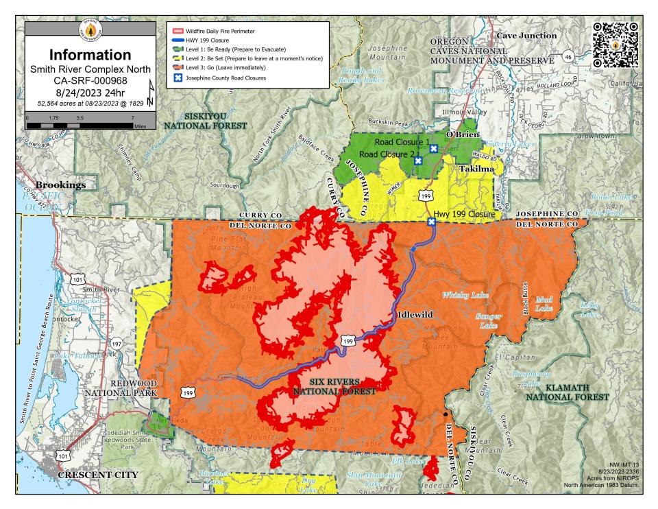
The most dangerous wildfire in the region, the Smith River Complex cluster of wildfires burning on the Oregon-California state line, grew to 52,563 acres by Thursday morning, up from 47,140 a day before.
U.S. Highway 199 remains closed at the border and evacuation warnings have been issued in both Oregon and California, although the situation is much more dangerous on the California side.
The blaze is burning most aggressively near the California outpost of Gasquet, and to the northeast of Crescent City. The fire remains about 6 to 7 miles from some of the world's tallest trees at Jedediah Smith Redwoods State Park. The park is currently closed.
The red flag warning in place across western Oregon and northwest California could bring an added element of danger Thursday night into Friday.
"Widely scattered, fast moving thunderstorms are expected to move over the Illinois Valley around 6 p.m. this evening and last through the late evening hours. Any thunderstorms that form will bring dangerous lightning and erratic outflow winds that may be as strong as 40 mph. Additionally, dense smoke forecasted to move over the area will make it extremely difficult to visually see thunderstorms building overhead," said Jonathan Chriest, incident meteorologist on the fire.
Based upon the most current weather forecast and in the interest of public safety, the Smith River Complex North public meeting scheduled for 6 p.m. will be virtual only on Smith River Complex North 2023 Facebook page.
“Thunderstorms usually bring gusty, erratic winds which can cause the fire to grow rapidly and in unexpected places. Temperatures are also expected to be warmer, with low relative humidity. If new fires are detected nearby, firefighters assigned to Smith River Complex north will assist with initial attack,” a Thursday morning report said.
Two different major incident management teams are managing the north and south ends of the fire.
Full details on the blaze can be found at bit.ly/47Ntd8r
Bedrock Fire containment upped to 45% as firefighters prepare for winds
Bedrock Fire incident commander Chris Hutsell said all the work firefighters have done to gain 45% containment of the 30,000-acre fire east of Eugene will be tested Thursday and Friday.
“We are confident our diligent work will withstand the weather we will see today,” Hutsell said in a Thursday morning report.
A virtual community meeting will be held at 5 p.m. Friday via Facebook Live on the Bedrock Fire 2023 page. There will be a live question-and-answer session following the presentations. For those who cannot attend, it will be recorded and available for viewing.
Also in the update: “Burnout operations on the northwest area of the fire have successfully removed most unburned fuels between primary containment lines and the edge of the fire. Today, crews will focus on identifying hotspots and mopping up within the containment lines in the Little Fall Creek area to strengthen and widen existing firelines. Around the remainder of the fire perimeter, firefighters are increasing the depth of the line, and patrolling where lines are confidently secure.”
The most recent evacuation warnings can be found at bit.ly/3YP1YWX. A map showing the public land closure around the fire can be found at bit.ly/3QPvw4Y.
Salmon Fire closure lifted as campgrounds, recreation sites reopen
After the 135-acre Salmon Fire, northeast of Oakridge, reached full containment, forest officials lifted the surrounding public lands closure and reopened a number of recreation sites.
"Due to firefighters' quick response to the Salmon Fire, the area is now open again," a news release said. "There were no fire impacts to any recreation sites."
Salmon Creek Falls Campground reopened on Tuesday.
Flat Fire remains 58% contained in southwest Oregon
The 34,000-acre Flat Fire reached 58% containment by Wednesday morning in southwest Oregon outside Brookings.
"Hot, dry conditions contributed to low rates of fire spread in interior islands of unburned fuels. A small number of torching trees were observed but did not threaten fire lines. Depending on wind direction, smoke may have some limited impact on firefighting efforts and local communities. All firefighting resources remain engaged, patrolling containment lines, and monitoring isolated heat sources on the edge and in the interior," a Wednesday report said.
Zach Urness has been an outdoors reporter in Oregon for 15 years and is host of the Explore Oregon Podcast. Urness is the author of “Best Hikes with Kids: Oregon” and “Hiking Southern Oregon.” He can be reached at zurness@StatesmanJournal.com or 503-399-6801. Find him on Twitter at @ZachsORoutdoors.
This article originally appeared on Salem Statesman Journal: Oregon wildfires: Red flag warning could mean fire growth, new blazes

