Oregon wildfires: Boulder Fire grows to 160 acres near Mount Hood, closes campgrounds
This story was updated at 5 p.m. Monday, July 10
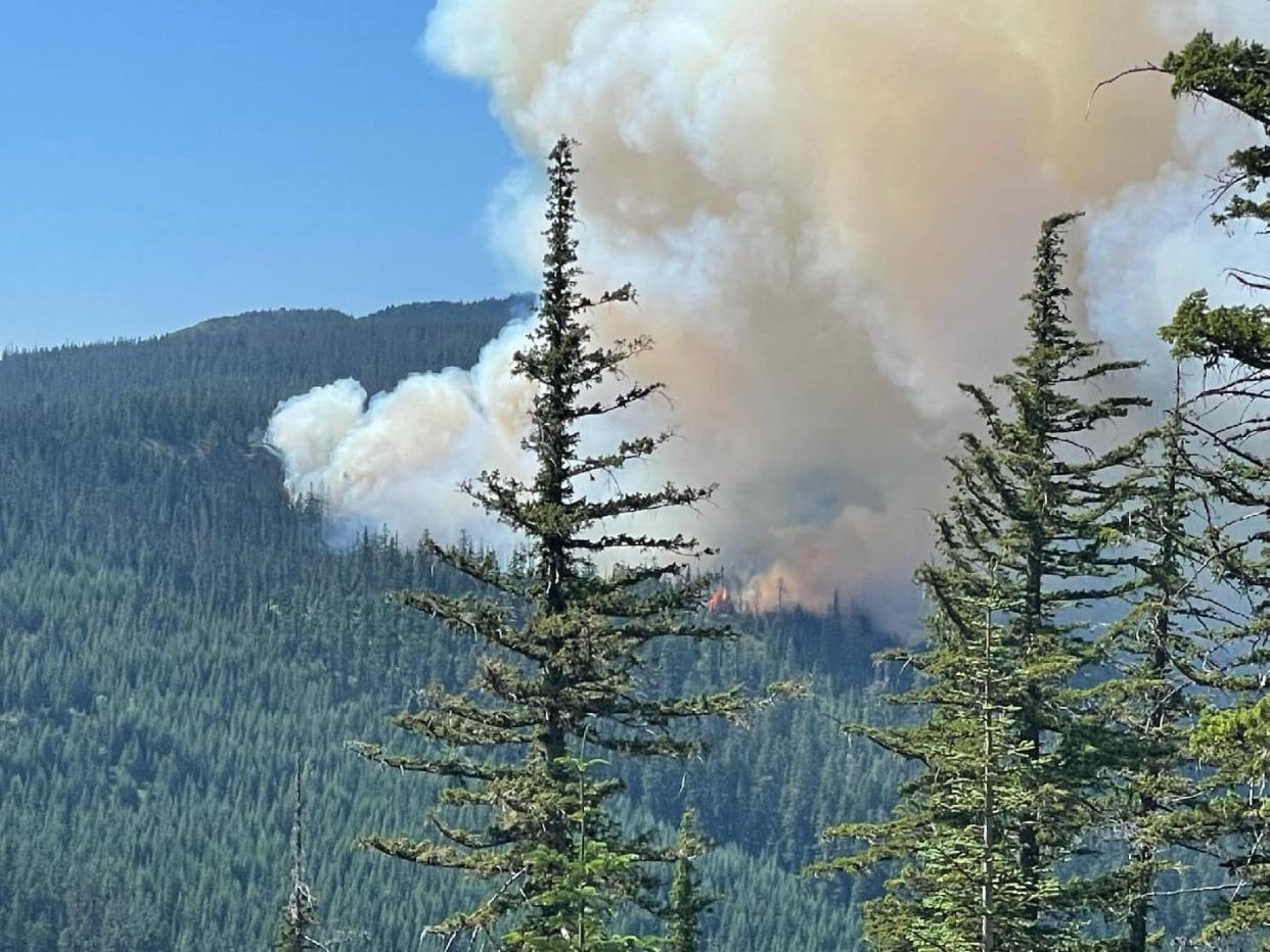
A wildfire that ignited Saturday southeast of Mount Hood grew to 160 acres and has closed multiple campgrounds near Boulder Lake, fire officials said Monday.
The Boulder Fire is one of a handful of medium-sized fires growing amid hot and dry conditions that have brought high fire danger to much of Oregon.
The fire started near the Boulder Lake Trailhead, a popular recreation area about nine and a half miles southeast of Government Camp. It is burning dead debris in steep slopes and rugged terrain, the U.S. Forest Service said in a news release. The cause of the fire is under investigation.
Due to the fire, a number of campgrounds and nearby recreation sites are under evacuation or closed, including: Boulder Lake campground, Little Boulder Lake, Bonney Meadow campground, Badger Lake campground, Camp Windy, and Post Camp campground.
“Smoke impacts are anticipated in the vicinity of the fire, with warm and dry conditions forecast to persist throughout the week,” officials said.
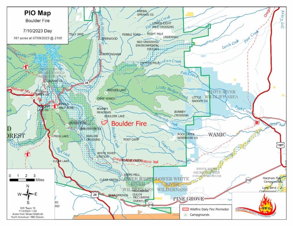
The Northwest Incident Management Team 10 assumed command of the fire on Monday. The crew includes 200 personnel, two water scoopers and four helicopters.
Over the past 48 hours, a mix of local resources from the Mount Hood National Forest has been fighting the fire with the support of helicopters and fixed-wing aircraft.
Forest Roads 4480, 4481 and 4890 are closed. With heavy equipment and teams working on Forest Road 48, the news release added that the area also should be avoided.
Fire restrictions for Mount Hood National Forest and Columbia River Gorge Forest Service also began Monday. No campfires of any kind are allowed, including in designated fire rings at campgrounds. Because of dry conditions, target shooting is also prohibited.
For additional fire information visit the Mount Hood National Forest Facebook page at facebook.com/mthoodnf/.
Map: Wildfires and smoke in Oregon
Devils Butte Fire
A new wildfire, known as the Devil's Butte Fire, ignited Monday northwest of Condon. The fire grew to roughly 3,000 acres and has brought a closure to Highway 206 in the fire’s vicinity.
The #DevilsButteFire is estimated at between 2,500-3,000 acres. The fire is primarily moving in a N/NE direction. Firefighters are working to keep fire west of Hwy 206 & have caught spots thus far that have crossed the road.
⛔️Hwy 206 is currently closed in the fire’s vicinity. pic.twitter.com/5SfxUYEwFc— Central OR Fire Info (@CentralORFire) July 10, 2023
Fire reported outside Sisters
Firefighters are battling a small fire near Lower Three Creek Sno Park outside Sisters in Deschutes National Forest.
The fire is just under and one acre and fire crews have a hose line around the fire, officials said.
"Firefighters have stopped forward progress on (the fire) and have a hose around the fire and are constructing hand line," Central Oregon Fire Information said.
For the latest updates see: https://twitter.com/CentralORFire
Moonlight Fire, Three Sisters Wilderness
The lightning-ignited fire in the Mink Lake Basin north of Park Trail was officially out Monday afternoon.
Crews finished mopping up the fire and suppression repair work in the area in the morning. All personnel and equipment have been released, according to a social media post from the Willamette National Forest.
In all, the Moonlight Fire burnt about 2 acres.
“Firefighters also put out seven small fires, many abandoned campfires, in the forest this weekend,” the post read. “'Smothering a fire with dirt is not sufficient to put the fire 'dead out'... drown with water, stir, drown.”
Alder Creek Fire, John Day Basin
Low temperatures and showers Monday morning were appreciated at the Alder Creek Fire.
The fire is being held at 1,550 acres in the John Day River basin. While tree torching and some smoke is visible, local teams will take over the efforts from the Central Oregon Fire Management Service Type 3 team Tuesday.
The Muleshoe Campground reopened to the public Monday.
Tunnel 5 Fire
The 529-acre fire is 80% contained, officials said in a final update Monday. Located in Washington alongside the Columbia River Gorge, all Skamania County evacuation orders have been lifted.
Firefighting resources and the Northwest Incident Management Team 12 was demobilized Monday, with a Type 4 Incident Management Team taking control of the scene. Crews will continue to patrol the area over the next several days.
Washington State Route 14 remains closed between mile markers 56-65 because of safety hazards. While teams are working to clear the path, road closure updates can be found on the Washington State Department of Transportation website.
The cause of the fire remains under investigation.
Bend area brush fires
The bush fire outside of Bend was 100% contained Sunday evening.
The fire sat at 1/3 acre in size and was seven miles southwest of Deschutes River Woods and Highway 97. Teams determined the fire was lightning-caused.
For the latest information, visit twitter.com/CentralORFire.
Zach Urness has been an outdoors reporter in Oregon for 15 years and is host of the Explore Oregon Podcast. To support his work, subscribe to the Statesman Journal. Urness is the author of “Best Hikes with Kids: Oregon” and “Hiking Southern Oregon.” He can be reached at zurness@StatesmanJournal.com or (503) 399-6801. Find him on Twitter at @ZachsORoutdoors.
Abigail Landwehr is an outdoors journalism intern for the Statesman Journal. She can be reached at alandwehr@gannett.com
This article originally appeared on Salem Statesman Journal: Boulder Fire near Mount Hood closes campgrounds, grows to 160 acres

