Oregon wildfires: Critical fire weather could hit this week, Smith River Complex grows
For the latest updates on Oregon's major wildfires, air quality alerts and latest information, see today's updates.
Fire danger is expected to increase across western Oregon later this week as thunderstorms arrive, and the Smith River Complex has continued to grow on the Oregon-California state line as fire danger reaches its peak part of the season.
Here's the latest updates on wildfires and wildfire conditions around the state.
Heat and new thunderstorms could bring critical fire conditions Thursday-Friday
High temperatures, dry conditions and potential thunderstorms could bring critical fire weather to northwest Oregon late this week, mainly Thursday night and into Friday, meteorologists said.
Thunderstorms with the potential for lightning — and new fire starts — are forecast across the length of northwest Oregon, from the Cascade Range into the Coast Range.
That could bring critical fire danger to places such as Mount Hood National Forest and down the length of the Cascade Crest.
The storms could also bring high winds that cause existing fires — such as Lookout and Bedford — to grow.
Thunderstorm chances return to NW OR & SW WA this week:
➡️Cascades: Thursday afternoon - Friday afternoon
➡️West of the Cascades: Thursday evening - Friday morning
➡️Main impacts are lightning, brief heavy rain, gusty winds, & possible fire starts from lightning #ORwx #WAwx pic.twitter.com/opbbNKgT7Q— NWS Portland (@NWSPortland) August 23, 2023
As ever, much will depend on how much lighting and how much rain arrives with the thunderstorms. A fire weather watch is in place but that could be upped to a red flag warning if the forecast holds and conditions look increasingly dangerous.
“We could get some moisture with this system but it’s so dry on the surface, so we’ll have to see,” said Andy Bryant with the National Weather Service in Portland. “We’ll have pretty gusty winds that could spread existing fires. And we’re in the 90s into the weekend with low humidity. I think we could see critical conditions in the Cascades and Cascade Foothills.”
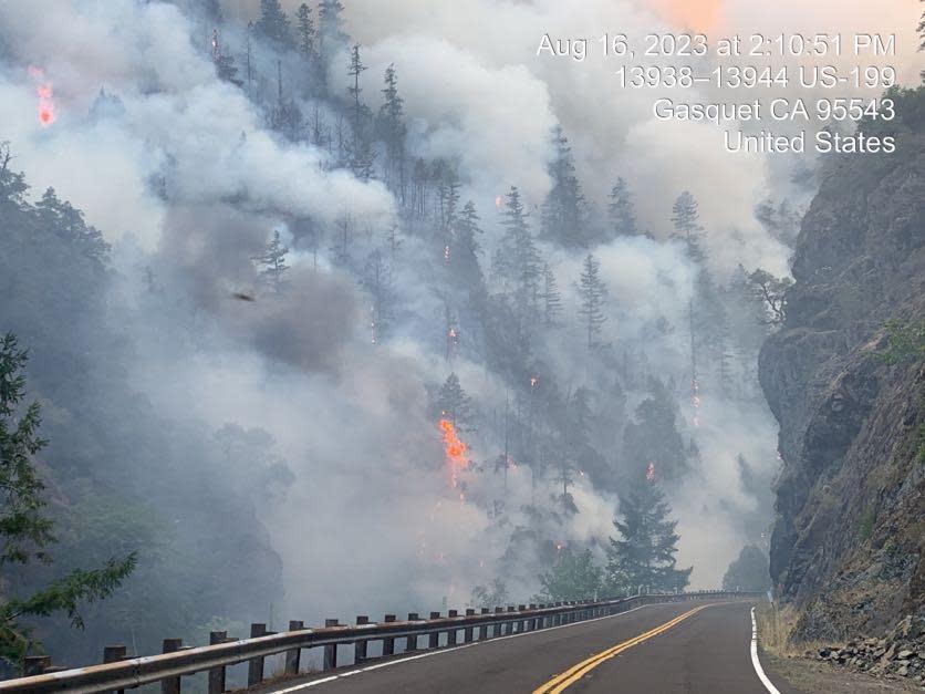
Fast-growing Smith River Complex pushes into Oregon, but also creeps closer to redwoods
The most dangerous wildfire in the region, the Smith River Complex cluster of wildfires burning on the Oregon-California state line, grew to 47,140 acres by Wednesday morning, up from 40,000 a day before.
U.S. Highway 199 remains closed at the border and evacuation warnings have been issued in both Oregon and California, although the situation is much more dangerous on the California side.
The blaze is burning most aggressively near the California outpost of Gasquet, and to the northeast of Crescent City. The fire remains about 6 to 7 miles from some of the world's tallest trees at Jedediah Smith Redwoods State Park. The park is currently closed.
Cooler marine air helped firefighters on Tuesday, allowing a fleet of VLATS (very large air tankers) to drop 300,000 gallons of retardant, an update on Wednesday said.
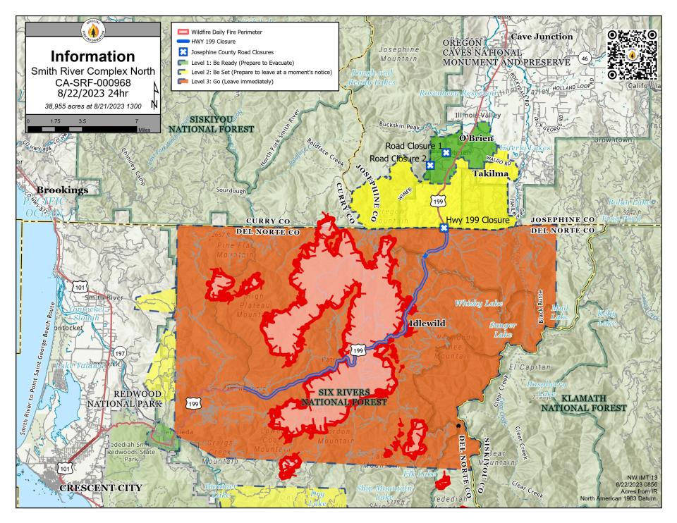
However, the fire has also pushed north into Oregon, including up the West Fork of the Illinois River valley.
"In response, local firefighters and resources concentrated on structure protection work around Lone Mountain and Elk, Blue, Dwight, and White creeks. Protecting structures, powerlines, and resources along Highway 199 are a high priority for this fire," a Wednesday report said.
Two different major incident management teams are managing the north and south ends of the fire.
Full details on the blaze can be found here.
Lookout Fire throws out spot fires, but evacuation levels again decreased
Fire behavior was moderate at the Lookout Fire on Tuesday with the exception of several spot fires across Deer Creek Road on the fire’s northeast flank, a Wednesday morning report said.
"Hand crews and engine crews are making good progress containing the spot fires, assisted by water dropping helicopters," the report said.
The Lookout Fire didn't grow much, reaching 13,207 acres with just 6% containment. However, warming weather could bring critical fire weather along with thunderstorms on Thursday.
Another evacuation level downgraded from level 3 (go now) to level 2 (get ready) and that was in "areas east of the McKenzie Bridge to, and including Drury Lane and north of Highway 126, but south of the McKenzie River."
A shelter remains in place at Lowell High School for evacuees and small pets from the Bedrock and Lookout fires. A large animal shelter is set up at the Lane County Fairgrounds in Eugene.
The most recent evacuation warnings can be found at bit.ly/3EaghvI. A map showing the public land closure around the fire can be found at bit.ly/3QPvw4Y
Poor air quality impacting central and southern Oregon
While air quality improved to healthy levels in the Willamette Valley and northwest Oregon, the same is not true for central and southern Oregon.
The Bend and Medford areas were both hit with unhealthy air quality as ocean winds push smoke east. An air quality alert was in place for both areas until at least 5 p.m. Thursday.
Northwest Oregon's air quality should stay in good shape through the rest of the week, even though the area has missed out on rainfall left over from Hurricane Hilary.
“We should be good on smoke at least into the weekend, but in terms of rainfall, we’re unfortunately the dry spot on the map,” said Tanja Fransen of the National Weather Service.
Bedrock Fire teams putting up smoke from back-burns meant to increase containment
A large plume of smoke went up Tuesday from the 31,196-acre Bedrock Fire burning east of Eugene. The smoke was the result of "increased solar radiation and winds from the west contributed to increased fire activity in the areas firefighters were performing burn out operations," a Wednesday report said.
Primary containment lines stayed secure, and the fire remained within the perimeter, the update said.
Crews are burning around the edges of the fire to reduce fuels between primary containment lines and the edge of the fire increase containment of the blaze — in effect keeping it in a box. The blaze is 35% contained, and fire crews are looking to increase that number.
"Today, warmer, drier weather gradually returns to fire area. As weather conditions remain favorable, firing operations will continue. A smoke plume will likely be visible today with similar weather conditions as yesterday. On contained portions of the fire, crews are increasing the depth of the fire line, and patrolling where lines are confidently secure," the report said.
The most recent evacuation warnings can be found at bit.ly/3YP1YWX. A map showing the public land closure around the fire can be found at bit.ly/3QPvw4Y.
Salmon Fire closure lifted as campgrounds, recreation sites reopen
After the 135-acre Salmon Fire, northeast of Oakridge, reached full containment, forest officials lifted the surrounding public lands closure and reopened a number of recreation sites.
"Due to firefighters' quick response to the Salmon Fire, the area is now open again," a news release said. "There were no fire impacts to any recreation sites."
Salmon Creek Falls Campground reopened on Tuesday.
Reopened trails include: Dead Mountain Trail #3566, Salmon Creek Trail #4365, Cross-Country River Trail #4365.
Reopened trailheads include: Flat Creek Trailhead, Salmon Creek Trailhead
Flat Fire remains 58% contained in southwest Oregon
The 34,000-acre Flat Fire reached 58% containment by Wednesday morning in southwest Oregon outside Brookings.
"Hot, dry conditions contributed to low rates of fire spread in interior islands of unburned fuels. A small number of torching trees were observed but did not threaten fire lines. Depending on wind direction, smoke may have some limited impact on firefighting efforts and local communities. All firefighting resources remain engaged, patrolling containment lines, and monitoring isolated heat sources on the edge and in the interior," a Wednesday report said.
Crews mop-up all fires from previous thunderstorm in southern Oregon
Following thunderstorms that brought close to 300 lightning strikes into the Rogue Valley over the weekend, firefighters have extinguished 13 fires that were naturally sparked by the storm, a news release said on Wednesday.
Zach Urness has been an outdoors reporter in Oregon for 15 years and is host of the Explore Oregon Podcast. Urness is the author of “Best Hikes with Kids: Oregon” and “Hiking Southern Oregon.” He can be reached at zurness@StatesmanJournal.com or 503-399-6801. Find him on Twitter at @ZachsORoutdoors.
This article originally appeared on Salem Statesman Journal: Oregon wildfires: Critical fire weather arrives, Smith Complex grows

