Oregon22: From coast to Cascades, take a day trip to explore Lane County and beyond
While Eugene and Springfield have plenty to offer, there's a chance for visitors to escape to the coast or the Cascades and beyond.
Full-day trips offer sights of alpine lakes, stunning rock features and snow-capped mountains and the chance to visit world-class breweries and restaurants or even the last Blockbuster in the world. We asked Register-Guard readers for their recommendations for day trips as thousands of people visit for the World Athletics Championships Oregon22.
Here are five day trips from a combination of options recommended by locals. We recommend leaving by 10 a.m. for most of these — especially for Crater Lake and the drive to Bend.
Bend and Sisters via Cascade Lakes Scenic Byway and McKenzie Highway
Two scenic routes offer a loop to Bend and Sisters and back from Eugene.
The Cascade Lakes Scenic Byway juts off from OR-58 just southeast of Odell Lake and winds more than 70 miles past lakes, forests and mountain views before meeting up with US 97 in Bend.
There are day-use areas at many of the lakes, and some offer rentals for visitors wanting to kayak, canoe or enjoy other water sports.
More visitors' guides: 15 things Eugene locals say Oregon22 visitors should check out
Bend offers lots of opportunities to wet your whistle, sate your appetite and explore the outdoors around the Deschutes River. The city's Old Mill District offers opportunities for dining and shopping right alongside hiking trails and fishing spots.
Heading north on 97 from the center of Bend, there's an opportunity to visit the world's last Blockbuster before heading northwest on OR-20 toward Sisters.
Named for the trio of towering peaks to its west, Sisters is a vibrant, artsy community with charming 1880s facades and small-town ambience.
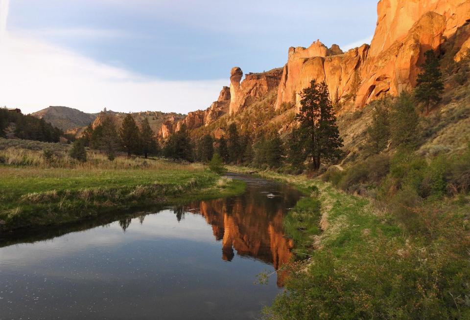
There's also an option to stay on 97 all the way up to Smith Rock State Park to see the towers of volcanic ash that serve as one of the seven wonders of Oregon.
From the park, head back south to OR-126 and across to Sisters.
Use OR-242, the McKenzie Highway, to head west back toward Eugene. There are multiple scenic viewpoints, including the Dee Wright Observatory, which offers views of Mt. Washington, Mt. Jefferson and the Three Sisters (and maybe even Mt. Hood) on clear days.
The highway is a little more than 35 miles and meets back up with OR-126 near McKenzie Bridge and Belknap Springs. Continue west on 126 for about an hour to make it back to Eugene.
Oregon Coast Highway
Oregon's coastal highway, Highway 101, winds along the western edge of the state and boasts soaring sand dunes, pristine state parks and bustling harbors.
Eugene offers easy access to the central and southern coast through Florence, which is a little more than an hour west of Eugene on OR-126.
The coastal city has the historic Siuslaw River Bridge and a quirky piece of history: the exploding whale. You can learn more about the event at Exploding Whale Memorial Park and, if you're lucky, Exploding Whale Pale Ale might be on tap at local Homegrown Public House and Brewery.
Read more:After 50 years, the exploding whale still lives as the oddest moment in the history of Florence
From Florence, head north or south on the 363-mile Oregon Coast Highway.
Heading north
About 10.5 miles north of Florence on US 101, you'll come to Sea Lion Caves.
The sea cave is the largest in the country and the year-round home of the Steller sea lion.
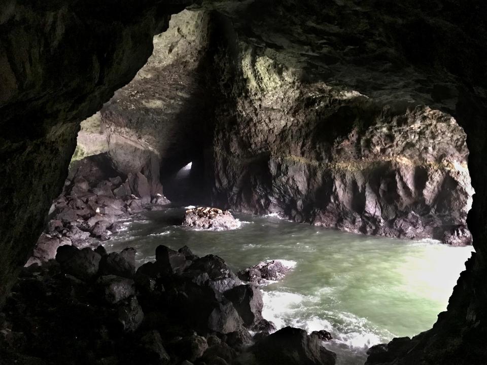
During the summer, the sea lions are less likely to be in the cave and instead often will hang out on the rock ledges outside the cave.
Head just a little more than a mile north of the cave on 101 to Heceta Head, a working lighthouse that's said to be the most photographed lighthouse in the United States.
After parking and paying the $5 fee, head up a half-mile trail to the lighthouse, passing lightkeeper’s house on the way up to the lighthouse and viewpoint.
There's an optional split upward onto the Oregon Coast Trail leading to Hobbit Beach. Even a portion of the trail offers stunning overhead views of the lighthouse and ocean and coastline beyond.
From Heceta Head, drive another 11 or so miles north to reach Thor's Well, a gaping, seemingly bottomless sinkhole swallows the unbroken stream of seawater around it.
Though the coastline feature isn't actually bottomless, it is dangerous. Getting to Thor's Well means venturing out onto slippery rocks, so tread lightly. Get the best views by visiting an hour before high tide then staying to see how it fills up.
Driving another half a mile gets you to Devil's Churn, a deep chasm in the coastline where the Pacific Ocean churns inside a wave-carved inlet.
The chasm likely started as a narrow fracture or collapsed lava tube in the volcanic bedrock. Over many thousands of years under the constant pounding force of the ocean waves, it's now more than 80 feet wide where it opens at the ocean.
There's a short, paved loop from the parking lot that takes you down to get a closer look of the coastal feature.
Drive another 26 miles north to reach Newport, where options for foodies abound. Then take US 20 and OR-34 east through Philomath and Corvallis to Interstate 5 and head south back to Eugene.
Heading south
To take the route less traveled, head south down US 101.
Just after crossing the Siuslaw River, turn right onto South Jetty Road. Follow the road for a few miles and continue on Sand Dunes Road. There will be multiple parking areas, then it's just a quick (though sometimes strenuous) trek up and down or through a sand dune to the ocean.
Backtrack out to 101 then head south another 20 or so miles to the Oregon Dunes National Recreation Area.
One of the largest expanses of temperate coastal sand dunes in the world, the stark, mist-shrouded views of dunes, forests, and ocean in such close proximity to one another are rare and hauntingly beautiful.
The encroaching sand dunes inspired Frank Herbert to write the 1965 novel "Dune."
Read more:Sci-fi classic 'Dune,' now returning to the big screen, was inspired by Florence, Oregon
Among the tree islands, open dunes, wetlands, and beaches you will find off highway vehicle riding, hiking, paddling, wildlife viewing, birding, camping, picnicking, sand play and more.
Head back out to 101 to continue south through Coos Bay to Sunset Bay State Park in the fishing village of Charleston, where a sheltered beach area offers the chance for a picnic lunch if you didn't eat in Florence, and then to Shores Acres State Park.
Once the grand estate of timber baron Louis J. Simpson, Shore Acres features a formal garden inspired by the original, with plants and flowers from all over the world. Beyond the garden, a trail leads to a secluded ocean cove at Simpson Beach, and another trail skirts the cliff's edge.
Backtrack north on 101 to OR-38, which leads back to I-5. Make a stop in Cottage Grove for a meal. Bartolotti's Pizza & Pasta, The Axe & Fiddle and Coast Fork Brewing's Brewstation and Feed are all in the downtown area.
For those who don't have a car but still want to explore a little on the coast, the Link Lane Eugene-Florence Connector offers an affordable way to reach Florence for a full-day trip.
Buses leave from Eugene as early as 7:25 a.m. and start departing Florence to return to central Lane County at 5:31 p.m. For more info, including a full schedule and rate information, go to link-lane.org/eugene-florence-connector.
Covered bridges
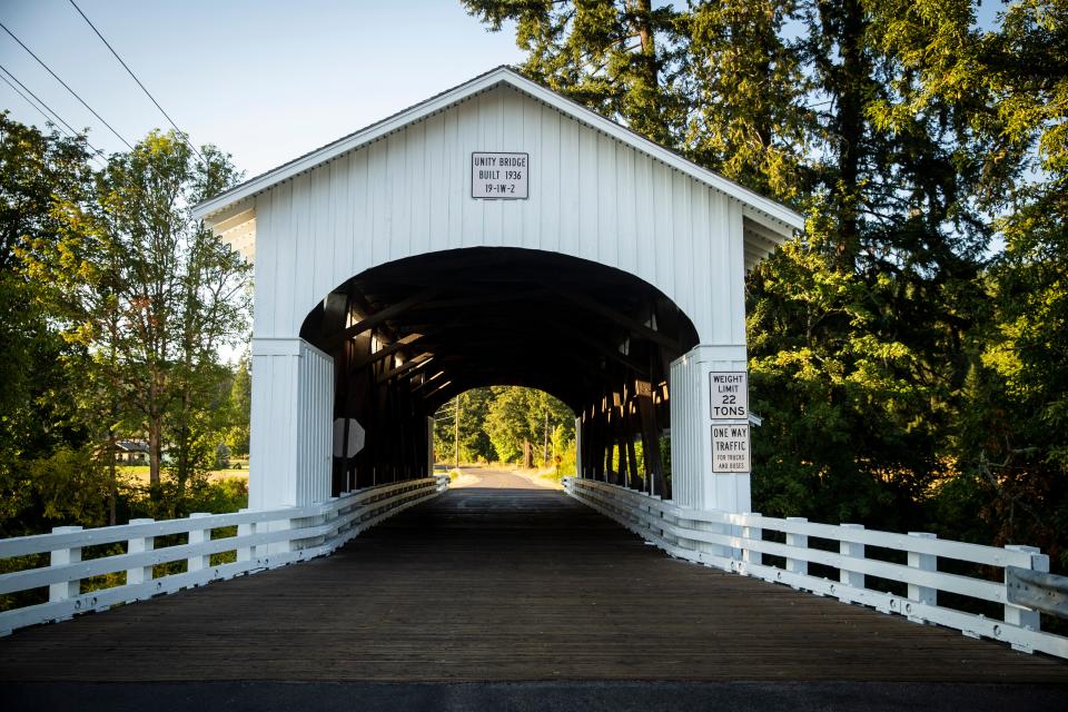
Lane County has more covered bridges than any other county west of the Mississippi River.
Twenty covered bridges, including 17 listed in the National Register of Historic Places, span waterways throughout the county, from nearly as far west as Mapleton to as far east as Belknap and south to Dorena.
Visitors can spend the majority of a day driving around to the different bridges.
There's more information on the county's covered bridges, including a pamphlet and a map, at lanecounty.org/government/county_departments/public_works/historic_covered_bridges_in_lane_county.
Crater Lake National Park
Formed by the collapse of Mount Mazama, the vibrantly blue Crater Lake that serves as the namesake of the national park is the deepest lake in the United States and the seventh deepest lake in the world.
With the north gate now open, it takes a little more than two hours to get to the park. Make sure you navigate to the north entrance or you'll end up adding at least 45 minutes to your trip.
More: 5 summer Oregon road trips explore mountains, desert, coast and ancient forest
It's $30 for most vehicles to enter the park during the summer, and there are varying rates for commercial vehicles and others entering the park:
$25 for motorcycles, admitting one or two passengers
$15 per individual for bikes, hikers and pedestrians with no motor vehicle
Rates from commercial vehicles ranging from $25 and $15 per passenger to $200, depending on the capacity of the vehicle. Organizations, businesses and individuals leading a commercial trip must apply for authorization before entering.
National parks passes also are valid for entry at the park. Learn more about entry fees and passes at nps.gov/crla/planyourvisit/fees.htm.
Note that because some winter road closures are still in effect, the road all the way around the rim is only partially open to vehicles as of July 15. That could change soon, so check out park conditions at nps.gov/crla/planyourvisit/conditions.htm. The entirety of the road is open for hiking and biking.
As of July 15, the East Rim Drive is open to vehicles up until the trailhead for the Sun Notch Trail on the south end of the lake and to Skell Head on the eastern side of the lake.
The Sun Notch Trail offers a clear view of the phantom ship and is a short, easy hike with little elevation gain.
There's also vehicle access to two other trails offering sweeping and unique views of the lake:
Watchman Peak Trail: Starting from the Watchman Overlook just south of where West Rim Drive and East Rim Drive meet, this trail climbs 400 feet to an old watchtower and a panoramic view of the lake and Wizard Island, a cinder cone near the western edge of the lake. The out-and-back trail is just under 2 miles long in total.
Cleetwood Cove Trail: This trail offers a steep and strenuous hike down to the lake. Starting at a trailhead 4.6 miles east of where West Rim Drive and East Rim Drive meet, it drops 700 feet in a little more than a mile through a series of long switchbacks. The trail is only partially shaded, and the surface is like fine sand, meaning it can be slippery when dry. People should be fit and have good cardiovascular and heart health, as climbing back up the trail is the equivalent of climbing 65 flights of stairs. The majority of search and rescue operations in the park happen because visitors hike down to the lakeshore and are unable to climb back up. Learn more about the trail, including what to bring and what to leave behind, at nps.gov/crla/planyourvisit/cleetwood-cove.htm
Dogs aren't allowed on either trail.
Rim Village is a good place to stop for views of the lake, lunch and souvenirs.
There's more information about the park, including what's open and trails throughout the rest of the park, at nps.gov/crla/index.htm.
Whitewater rafting
Rafting trips in Oregon offer everything from adventurous Class-V rivers in deep canyons to mellower whitewater rapids through verdant countryside.
There are multiple half-day and full-day rafting trips within a short drive from Eugene.
Some of the best are on:
North Umpqua River, offering a variety of whitewater thrills within a beautifully forested river canyon
Upper Klamath River, with a trip with a good warm-up of Class-III rapids before launching rafts into the Class-IV Hell’s Corner
McKenzie River, with continuous but fairly mellow whitewater and lush scenery
North Santiam River, a good trip for beginners
Deschutes River, which has one stretch that's the most popular rafting trip in the state: the “Big Eddy” section on the Upper Deschutes, accessed from Bend
Get more info at traveloregon.com/things-to-do/outdoor-recreation/paddle-sports/rafting/rafting-oregon-101/.
Megan Banta usually reports on local government for the Register-Guard. She's a Midwest transplant who's done most of the things on the list (she highly recommends Crater Lake and rafting on the McKenzie River) and wants to do the rest. Follow her on Twitter @MeganBanta_1.
This article originally appeared on Register-Guard: 5 day trips that locals recommend for visitors during Oregon22

