Oregon22 visitors: Want to go for a hike in or near Eugene? Here's what locals recommended
From roaring waterfalls to vast forests to small mountains in the middle of a city, there's plenty to see if you want to take a hike in Lane County or just over the county line.
We asked Register-Guard readers about the best hiking trails in the area as tens of thousands of people visit for the World Athletics Championships Oregon22.
Here's what they recommended.
Spencer Butte, Mt. Baldy and the rest of the Ridgeline Trail
The Ridgeline system rings the southern edge of the city with a series of large, semi-connected parklands.
The longest portion of the trail stretches from the Blanton Ridge Trailhead to the Spring Boulevard Trailhead and includes Mt. Baldy and Spencer Butte, the city's highest point and the crown of the Ridgeline at just more than 2,000 feet in elevation.
Mt. Baldy offers some views of the city and, sometimes, a peek at snow-capped mountains.
You can reach Mt. Baldy from the Spring Boulevard or Dillard East trailheads.
Spring Boulevard: A one-way trail up and down. Add some time and elevation by looping down to Dillard East and back up before heading back to the Spring Boulevard trailhead
Dillard East: Go up one way and come back down the other. We recommend going up the pedestrian trail and coming down the shared-use trail.
There will be trail markers clearly pointing you to either trailhead once you're at the top of Mt. Baldy.
For more sweeping views of the city, go up Spencer Butte. There are four main ways to get to the summit:
Main Trail at Spencer Butte Trailhead: The most popular route to the top. Gradually climbs up through a mature Douglas fir forest to a series of stone steps leading to the summit.
West Trail at Spencer Butte Trailhead: A shorter, but much more strenuous, route. The less-traveled path begins with rock-lined paths leading to exposed bedrock, which can require some scrambling, then a steep ascent following trail tags. If you take this path up, it's best to have your hands free for scrambling.
Fox Hollow to Tie Trail to Main Trail: Cross the road then meander through the forest to the Tie Trail, which goes through some of the oldest Douglas fir forest in the city's natural areas before meeting up with the main trail at an opening in the forest canopy.
52nd and Willamette to Tie Trail to Main Trail: Winds up through the forest for a little more than a mile before reaching the Tie Trail.
From Fox Hollow and 52nd and Willamette, there are signs clearly marking which way to go to reach the summit and return to the correct trailhead.
People also can start at trailheads farther away from the butte. For example, Blanton Ridge connects to 52nd and Willamette, and Martin Street and Spring Boulevard trailheads both connect in to Fox Hollow, either directly or through other trailheads.
Other sections of the Ridgeline don't connect to the large system of trailheads but still offer hikes rated as moderate.
Wild Iris Ridge, a newer section of the system, showcases upland prairie and oak habitat and offers views of Spencer Butte and the West Eugene Wetlands. And the Ribbon Trail connects into Hendricks Park, which offers its own set of trails totaling three miles.
There's a full map of the trail system, including unimproved trails and landmarks, at bit.ly/ridgeline-trail-map.
Skinner Butte
Multiple trails wind up and down Skinner Butte, leading to the summit where there's a parking lot with views of the city and, on a clear day, the Three Sisters, three mountains near Bend.
Skinner Butte, like its taller counterpoint to the south, is part of a city park.
There are trails available from a handful of parking areas at the base of the butte, and arrows clearly mark routes to the summit and back to parking areas, so keep track as you pass early markers to make it back to where you parked.
Skinner Butte also offers a unique feature − climbing columns.
An abandoned quarry on the western site of the butte became popular for rock climbing in the 1970s. A major volunteer effort renovated the 45-foot-high basalt columns more than a decade ago.
Climbers who want to scale the columns are on their own, though. The city doesn't maintain any climbing hardware, and people are responsible for assessing the safety of any anchors or other gear they plan to use.
There's a map of Skinner Butte, including a rough look at the trail system, at bit.ly/skinner-map.
Mt Pisgah
Located within the Howard Buford Recreation Area, Mt. Pisgah offers wide views of the valley and a peek of Diamond Peak from the top.
There are multiple trails leading to the summit, depending on where you park.
Here are some routes we'd recommend:
From the north lot and trailhead, you can follow trail #7 to trail #3 to trail #1. Come back down the same way or turn right on trail #14 from trail #1 then take trail #4 back to #3 and to #7 to return to the parking lot.
For a longer route from the north lot, take trail #3 around Swing Hill then past trail #7 to connect to trail #1.
From the west trailhead, take trail #1 straight all the way up to the summit and back down.
For a more strenuous hike, start at the east trailhead off Ridgeway Road and follow a loop on trails #2 and #6. Trail #6 is steeper, so it could be hard on knees coming down or a harder hike up.
With 17 miles of trails leading up and around the 1,518-foot tall butte, there are lots of connections between the trails that offer longer and shorter routes and different views. Some trails are even open to horses.
There's a map of the trails and trailheads available at bit.ly/HBRA-trail-map
Thurston Hills Natural Area
There are more than six miles of trails in the Thurston Hills Natural Area, including two intended solely for downhill mountain biking.
All trails are accessible for the north trailhead, located at 7575 McKenzie Highway on the eastern edge of Springfield.
At the trailhead, there are restrooms, an information kiosk, a picnic table, water and a bike cleaning and repair station.
There's a map of various routes at the trailhead, and the Mossy Maple Trail leads out of the parking lot for a somewhat easy climb up into the woods.
McKenzie River Trail, including Blue Pool, Sahalie and Koosah Falls
This trail parallels the scenic McKenzie River for 26.5 miles, passing through lava beds and dense, old-growth forests and by lakes, reservoirs, waterfalls and cold-water creeks.
There are 11 clearly marked trailheads on OR-126 that provide access to the trail. The closest is a little more than 50 miles from Eugene.
The trail begins upriver at the Upper McKenzie River Trailhead in an old lava flow before crossing a bridge over the river.
It gradually tracks downhill through old-growth trees and lava flows past Clear Lake and the Great Spring before crossing the highway to continue along the river.
It crosses the river before continuing to wind downward, offering scenic viewpoints overlooking Sahalie and Koosah Falls before continuing on to the Carmen Reservoir, where the river disappears underground for most of the year.
People who want a closer view of Sahalie and Koosah Falls can split onto the waterfalls trail, which goes down to Carmen Reservoir, where a quick jaunt on the road gets you back onto the McKenzie River Trail.
Though the river isn't visible most of the year, the trail continued along a dry creekbed for about two miles before reaching the Tamolitch Blue Pool.
The trail continues downstream, including through some rocky terrain, to the trailhead for Blue Pool, where the trail downriver is currently closed because of wildfire damage and a collapsed bridge.
That trail closure ends at Deer Creek Road, near the Belknap Hot Springs resort, where people could catch the trail to head downriver. From there, it continues west past Paradise Campground and the McKenzie River Ranger Station before reaching the Lower McKenzie River Trailhead.
There's more info about the trail, and a map, at fs.usda.gov/recarea/willamette/recarea/?recid=4479. Note that the Blue Pool trailhead often busy, and it could be a struggle to find parking.
Proxy Falls
The trail to Proxy Falls starts on OR-242, with parking on the side of the road.
The one-way trail immediately enters the Three Sisters Wilderness, moving south over an old lava flow then entering a mixed conifer forest.
There are two off-shoots on the trail that offer closer views of Lower Proxy Falls and Upper Proxy Falls.
The hike is a loop that leads back to the trailhead after Upper Proxy Falls.
People who want to hike the loop need a recreation pass or to pay $5 per vehicle and should fill out a wilderness permit before starting on the trail. There's more information, including a map and information on permits and passes, at fs.usda.gov/recarea/willamette/recarea/?recid=4458.
Salt Creek Falls
It's a short walk from the parking lot just off OR-58 to a wheelchair-accessible overlook of Salt Creek Falls, the state's second highest single-drop waterfall at 286 feet.
To the left of the viewing platform, the trail continues to loop around offering a short hike back to the parking lot or a somewhat longer hike following the Salt Creek through the picnic area.
To the right of the viewing platform, a more difficult spur trail takes off. The pavement ends at the top of the stairway, where the trail drops steeply into the canyon, ending near the base of the waterfall.
The parking lot also offers access to a 3.2-mile loop trail to Diamond Creek Falls and back.
People who want to hike the loop need a recreation pass or to pay $5 per vehicle. There's more information, including a map and information on permits and passes, at fs.usda.gov/recarea/willamette/recreation/recarea/?recid=82005
Read more in this story from 2019:Ready for the rush
Hardesty Mountain
People looking for a difficult hike or some good mountain biking can head to Hardesty Mountain.
Constructed in 1910, the trail leads up to a former fire lookout. All that remains of the lookout, which was in place from 1920 to 1968, are concrete pillars.
The trail climbs more than 3,000 feet in five miles from the trailhead just off OR-58, ending in a forest with scattered remnants of old-growth trees. Part of the trail leads along a forest road before branching sharply up to the left.
There isn't much of a view from the top, since sightlines are largely obscured by trees, but the winding trail offers pretty forest views. And while it's a steep hike, it offers some chances to meander along ridgelines.
People who want to tackle this hike need a recreation pass or to pay $5 per vehicle. There's more information, including a map and information on permits and passes, at fs.usda.gov/recarea/willamette/recarea/?recid=4592.
Trail of Ten Falls
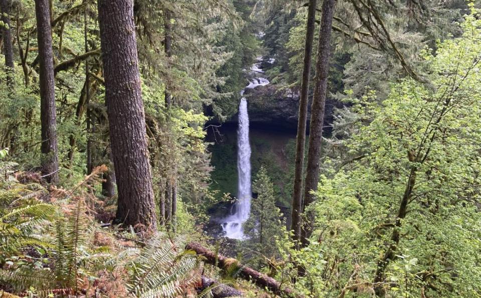
This waterfall loop in Silver Falls State Park takes visitors around 7.8 miles and dips before gaining 1,300 feet in elevation when going counterclockwise.
As the trail's name promises, there are no less than 10 waterfalls on the loop, which sees heavy traffic on even not-so-nice days.
There are a handful of trailheads on the loop, but most guides recommend starting at the South Falls Lodge and hiking counterclockwise, heading toward Winter Falls by heading through a picnic area and past Parking Area A then crossing a road to begin the Rim Trail.
Generally, the hike follows the Rim Trail and Canyon Trail, with some short cut-outs onto the Winter Trail and others to get closer views of some of the falls. The loop is rated as moderate and has sections with stairs, switchbacks and footbridges, and portions of it loop behind waterfalls into grottos.
There's a guide to the trail through a trailkeepers' service at oregonhikers.org/field_guide/Trail_of_Ten_Falls_Loop_Hike.
If people use AllTrails, following the numbers on the map goes in a clockwise loop starting with South Falls.
Note that dogs are not allowed on this hike.
Megan Banta normally reports on city and county government, but she's an avid hiker, backpacker and camper. Follow her on Twitter @MeganBanta_1.
This article originally appeared on Register-Guard: Eugene-area hikes for World Athletics Championships visitors

