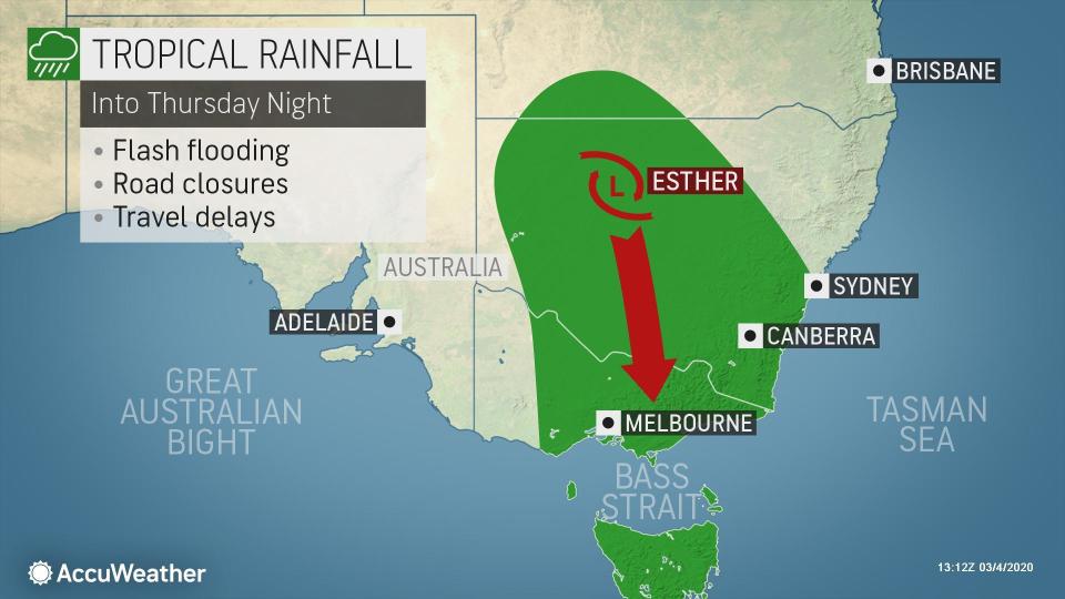
Esther targets Sydney, Melbourne with flooding rainfall late-week
After becoming a tropical system the third week in February, Esther continues to impact Australia with flooding rainfall.
Moisture from Esther has survived over a week after the former tropical cyclone made landfall in northern Australia. Now, heavy rainfall has amde it all the way New South Wales.
Esther made landfall as a Category 1 tropical cyclone, or the equivalent of a tropical storm in the Atlantic or East Pacific basins on Feb. 24 near the border between Queensland and the Northern Territory.
 |
While Esther quickly lost wind intensity while tracking westward over land, the core of its heavy rainfall largely remained intact, leading to a slew of issued flood warnings and alerts across the Northern Territory and northern Western Australia.
Upwards of 200 mm (8 inches) of rain was reported in the Kimberley region of Western Australia through Monday.
The storm has since made a turn to the southeast into central portions of the country.
"Former Tropical Cyclone Esther will continue to track through the southeast through the end of the week with heavy rain along its path," AccuWeather Senior Meteorologist Jason Nicholls said.
Downpours spread across the southern Northern Territory into eastern South Australia on Wednesday, and will target Victoria and New South Wales into Thursday night.
"Heavy rain and flooding are likely along the path of Esther with general rainfall of 50-100 mm (2-4 inches) likely with an AccuWeather Local StormMax(TM) of 150 mm (6 inches)," Nicholls said.
 |
CLICK HERE FOR THE FREE ACCUWEATHER APP
Road closures and washouts will be possible in the corridor of heaviest rainfall. Motorists should avoid driving through floodwaters and instead find a safer, alternate route.
 |
The above satellite image shows tropical moisture bringing increased cloud cover and rain in eastern Australia late on Wednesday, March 4 (Photo/RAMMB). |
Some of the heaviest rain may target Melbourne and Canberra, so those traveling in the region should be alert.
The risk of flooding in Sydney is likely to be more localized, but travel disruptions are likely in the metro area during the middle and latter part of the week.
Heavy rainfall at the Sydney Cricket Ground cancelled the semi-final match of the Women's T20 World Cup between India and England was cancelled on Thursday. This advanced India to the final match to take place on Sunday.
Sydney was hit with an excess of rain in February with nearly 381 mm (15 inches) of rain pouring down. During an average February, 95 mm (3.73 inches) falls on the city.
The bulk of the heavy rainfall will sweep off the southeastern Australia coast by Friday.
There are no immediate tropical threats behind Esther, but AccuWeather meteorologists are monitoring the potential for tropical development heading into the middle of the month.
Trough is pulling the former TC #Esther into SE #Australia with rain, some heavy, & areas of flooding likely in SW #Queensland, #NewSouthWales and #Victoria into Thursday. Still watching for development around the Gulf of Carpentaria and Cape York Peninsula next week. pic.twitter.com/bBYg9GUe6W
— Jason Nicholls (@jnmet) March 3, 2020
"We're monitoring an area over the Gulf of Carpentaria or Coral Sea next week, with the risk of heavier rain and flooding from the Top End to the Cape York Peninsula," Nicholls said.
AccuWeather will continue to provide updates on any potential tropical threats to Australia as they arise.
Keep checking back on AccuWeather.com and stay tuned to the AccuWeather Network on DirecTV, Frontier and Verizon Fios.


