Black ice causing hazardous travel conditions across Southeast in quick-hitting winter storm
A winter storm brought dangerous road conditions for drivers Friday morning in portions of the the Carolinas, Virginia and Georgia, as snow and sleet moved across the Southeast.
The National Weather Service warned of hazardous travel conditions through the morning hours due to snow and ice buildup on roadways in south-central portions of Virginia and northeast North Carolina.
Black ice was expected to clear up later Friday as temperatures warmed above freezing in northeast Georgia, western North Carolina and northern South Carolina, the weather service said.
Dozens of school districts were closed or started late Friday and hundreds of flights were canceled or delayed due to the storm, the Weather Channel reported.
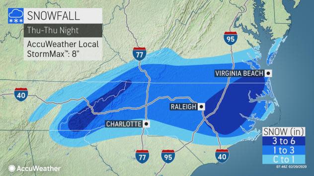
More than 12 million people had been under some form of a winter weather alert Thursday night into Friday, including the Charlotte and Raleigh metro areas.
A warm winter record: What happened to winter? And where's the polar vortex?
Keep up with news day and night: Get USA TODAY's Daily Briefing in your inbox
AccuWeather said the snow fell late into the late evening in some of the region's largest cities, including Richmond, Raleigh, Greenville, and even some of the mountainous areas of northern Georgia. Most were covered in a blanket of snow by the time the sun had set Thursday.
About 1 to 4 inches of snow fell across a large part of North Carolina and southern Virginia, the weather service said.
Many school systems in North Carolina and Virginia had also closed on Thursday in advance of the storm. Government offices in Durham County closed early, and Durham Public Schools, a district with more than 32,000 students, closed its schools Thursday.
North Carolina Gov. Roy Cooper and state emergency management officials urged residents to be prepared and monitor local forecasts ahead of the storm system, which began as rain.
"Portions of North Carolina are forecast to get more snow (Thursday) than Washington or Philadelphia have received all season," CNN meteorologist Monica Garret had said.
Winter snow totals in the I-95 corridor of the mid-Atlantic are way below normal – 0.6 of an inch in Washington, 0.3 of an inch in Philadelphia, and 4.7 inches in New York City thus far, AccuWeather said.
But the snow will be short-lived. After the storm concludes early Friday, temperatures will be ideal for melting as highs climb into the upper 40s on Saturday, 50s on Sunday and 60s on Monday, the Capital Weather Gang said.
While snow flew in North Carolina, much of the flood-ravaged Deep South saw a soaking rain Thursday, adding to what has been one of the wettest winters on record in that region, the Weather Channel reported.
Weeks of heavy rain have inundated a large portion of the southern U.S., bringing near-record flooding to portions of Mississippi and Tennessee. Jackson, Mississippi, was especially hard-hit as the Pearl River rose to its third-highest level on record, flooding hundreds of homes.
One wet winter: More rain forecast for flooded South during near-record wet winter
This article originally appeared on USA TODAY: Weather: Black ice, snowstorm hit Virginia, Georgia, Carolinas
