Pacific storm to spin heavy rain across Southern California, Southwest deserts

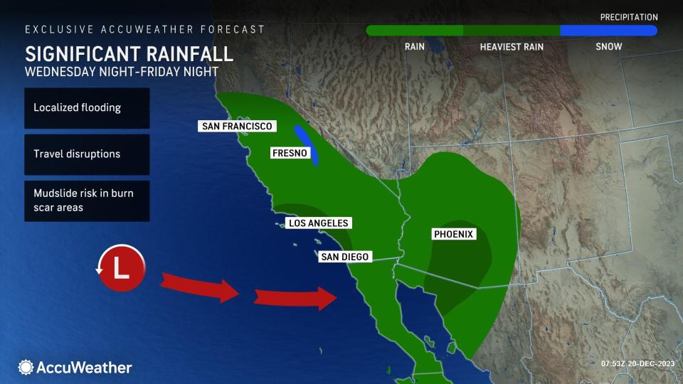
The much-awaited first major rain event with ties to a strong El Niño is on deck for Southern California this week, and the storminess could cause travel problems in other parts of the West into the Christmas holiday, AccuWeather meteorologists say.
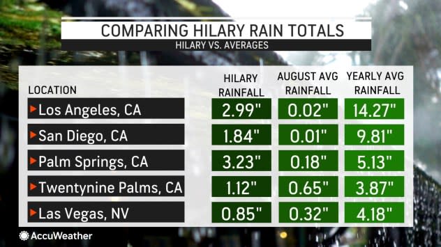
The biggest rainstorm since Hurricane Hilary is brewing for the latter part of this week and this weekend. The rare hurricane dropped a general 1-3 inches of rain and local amounts to nearly 6 inches in Southern California on Aug. 20 and 21.
 |
Since Hilary, most areas in Southern California have received only a few hundredths of an inch of rain.
Downtown Los Angeles has picked up only 0.64 of an inch since the last raindrops from Hilary fell, despite a typical ramp-up during the autumn season that brings a historical average of 2.76 inches.
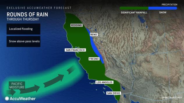
Even though the main body of the upcoming storm may remain offshore until the weekend, it will pump Pacific moisture toward Southern California through at least Friday, AccuWeather Senior Meteorologist Adam Douty explained.
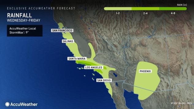
"Downtown Los Angeles has a good chance to pick up 2 inches of rain or more from the storm during the second half of this week," Douty said. He added that heavier rain is likely to fall on the west- and southwest-facing slopes of the Coast Ranges with perhaps two to three times the amount that drenches the Los Angeles basin.
 |
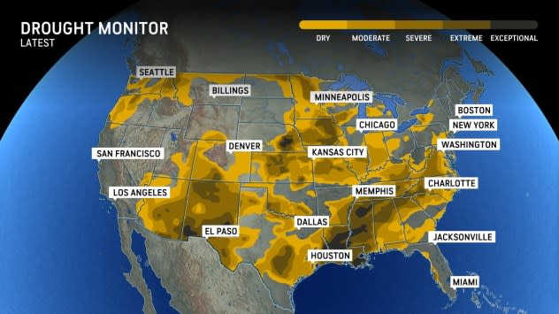
Even though much of California is officially not in drought, the later start to the winter storm season has the soil and brush remaining drier than typical for the second half of December.
Periodic rain and drizzle will continue in the northern and central parts of California through midweek due to some moisture that arrived from the Pacific over the weekend.
However, as the storm spins southward just off the coast, rainfall will ramp up late Wednesday and Wednesday night from San Luis Obispo, Santa Maria and Santa Barbara, California.
 |
The worst conditions associated with the heaviest and steadiest rain around Los Angeles are likely from Wednesday night to Thursday night and around San Diego from Thursday night to Friday.
Motorists should anticipate slick roads due to the wet conditions as well as the likelihood that some city roads will be flooded and secondary roads in the hilly terrain may become blocked by rocks and debris flows.
Because the center of the storm and the associated dip in the jet stream with colder air will remain offshore until the last minute, freezing levels will remain high over California this week.
"All or mostly rain will fall on Interstate 80 at Donner Pass and Truckee, California, this week," AccuWeather Meteorologist Haley Taylor said.
 |
With the air remaining so warm with the storm, only rain will fall on Tejon and Cajon passes in Southern California. However, motorists should be prepared for dense fog and gusty winds at times over the high ground along interstates 5, 8 and 15 later this week.
The storm will push inland from Friday to Saturday. Enough moisture will survive the trip over the mountains to bring rain to many desert locations from Southern California and southern Nevada to much of Arizona.
Drought conditions remain widespread in Arizona and New Mexico, according to the United States Drought Monitor. Any non-flooding rainfall in these areas would be welcomed.
 |
Similar to Los Angeles, Phoenix has received only 0.46 inches of rain since Sept. 1, compared to a historical average of 2.14 inches for the approximate three-and-a-half month period. The Phoenix area could pick up an inch of rain from the storm spanning Thursday night to Saturday.
Las Vegas has fared a little better in the rainfall department since Sept. 1, with rainfall of 1.5 times that of the historical average. The city has picked up 1.72 inches of rain since early September, compared to a historical average of 1.18 inches. The storm late this week has the potential to bring a few hundredths of an inch to perhaps an inch of rain to the metro area.
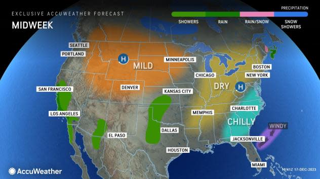
Farther north, a couple of days of dry weather are in store in the Northwest.
 |
However, a new storm will pivot ashore from the northern Pacific and will bring colder air with it as early as Thursday night. That colder air and moisture will translate to lower freezing levels and snow over the passes in Washington and Oregon on Friday and Friday night, with a cold rain along the I-5 corridor.
Moisture from the two storms will coalesce over the interior West during the extended Christmas weekend with areas of low-elevation rain and mountain snow that could cause travel problems, especially over some of the passes.
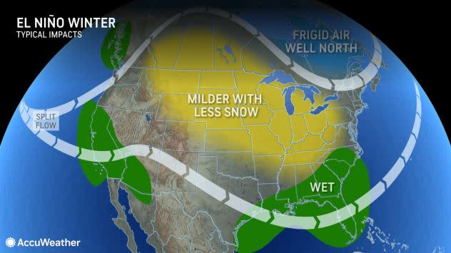
Despite the upcoming drenching storm for Southern California late this week and the potential for a historically strong El Niño to evolve with plenty of precipitation for Northern California likely, AccuWeather's Long Range Team is cautioning that there is no guarantee of consistent storms and well-above-historical average rain for Southern California this winter.
 |
An El Niño pattern often ushers in an active storm track and resultant wetter conditions than the historical average across southern parts of the U.S. |
The strength of El Niño could be diminished by other factors. The underlying problem, as far as storms missing California, has to do with variable sea surface temperatures north of the tropical Pacific.
Want next-level safety, ad-free? Unlock advanced, hyperlocal severe weather alerts when you subscribe to Premium+ on the AccuWeather app. AccuWeather Alerts™ are prompted by our expert meteorologists who monitor and analyze dangerous weather risks 24/7 to keep you and your family safer.
