Palm Desert council reaffirms support for map splitting city’s north end despite pushback
A majority of the Palm Desert City Council reaffirmed its support Thursday for a voting map that would split the city's fast-growing northern end between two districts, despite some pushback from residents of the area who favored another map.
The decision comes as Palm Desert transitions to a five-district council system that will be in place for the 2024 election.
The city’s switch from two to five council districts was approved by the council in June, after a majority of the city’s voters — roughly 53% — supported the move on an advisory ballot measure in last year’s general election.
Under the city’s current setup, residents of District 2 — which includes about 80% of the city’s population — vote for four councilmembers, while the smaller District 1 — which covers the Civic Center area and surrounding neighborhoods — has one representative.
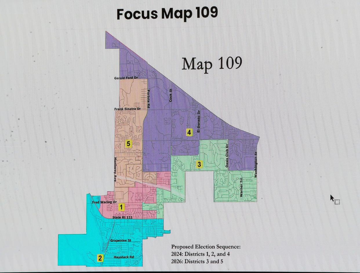
Known as Map 109, the option backed by the council divvies up District 2 into four separate districts, while District 1 — which was the product of a voting rights lawsuit filed in 2019 — will remain intact.
After several public hearings and workshops, the council plans to adopt a final map during its Jan. 11 meeting.
From two to five districts: How did we get here?
Palm Desert had at-large voting for its five council seats until 2019, when two residents filed a lawsuit against the city saying it was in violation of the California Voting Rights Act, which requires cities to ensure minority voting groups have a fair chance for representation.
That lawsuit led to the two-district setup. While Latino residents make up just over a quarter of its population, Palm Desert didn't have its first Latina council member until Mayor Karina Quintanilla — one of the suit's plaintiffs — won election in District 1 after it was created in 2020.
Roughly 44% of the voting-age population in District 1 is Latino, and city officials say any reductions in that percentage could risk a legal challenge, meaning the council has largely focused on drawing four other districts around that one.
What are the preferred map's districts?
The city accepted publicly submitted maps for several weeks this fall, and city officials have worked with National Demographics Corporation to develop other options and adjust maps from the public that didn’t properly balance the city’s population across the five districts.
The map advanced by the council, which was submitted by the demographer, would divide the city into the following districts:
District 1 would remain the same as its current version, covering Civic Center Park and some surrounding areas along Fred Waring Drive and north of Highway 111.
District 2 would cover all of the city south of Highway 111, as well as a small area on the west end of Highway 111 on the opposite side of the road.
District 3 would have all of Interstate 10 as its northern border, extending east to the Woodhaven Country Club. It would also include the Spanish Walk community, the Desert Willow Golf Resort and the areas surrounding the city’s campuses affiliated with California State University-San Bernardino and University of California-Riverside.
District 4 would largely go around the city limits of Indian Wells, extending east to Washington Street. It would include all of the Palm Desert Country Club, The Oasis Country Club and Indian Ridge Country Club, as well as the Hidden Palms gated community.
District 5 would largely be between Portola Road and Monterey Avenue, running south of Gerald Ford Drive down to College of the Desert. It would include Monterey Country Club, Chaparral Country Club, Suncrest Country Club and The Regent Palm Desert.
Under the proposed map, known as Map 109, the council election for Districts 1, 2 and 3 would be held in 2024, while the election for Districts 4 and 5 would be in 2026.
What the public said
The city heard a mix of responses Thursday. Several residents from the city’s north end urged the council to reconsider a map that would create a single district covering the city’s northern end, from Interstate 10 south to Country Club Drive, except for a small area east of Tamarisk Row Drive.
That option submitted by Gregg Akkerman, who ran for a council seat last year, was rejected by the council last month due to its splitting of a gated community — which multiple members said was a clear community of interest — into two districts.
More: Palm Desert council's favored district map draws criticism for splitting city's north end
But in the weeks since the council’s mid-November meeting, Stephen Nelson, a resident of the city’s north end, found that map could avoid dividing any HOAs or gated neighborhoods by swapping the Hidden Palms community into another district for a few other properties along Country Club Drive.
Nelson, who also leads the Genesis community’s HOA, told the council Thursday that splitting the city’s north region into two districts would be irresponsible, noting all of the city north of Frank Sinatra Drive falls into the Palm Springs Unified School District, along with other shared issues.
Another resident of the area, Michael Stafford, criticized the council’s decision to only advance one map in its mid-November meeting, despite the city’s redistricting timeline saying it would advance two to three focus maps. The criticism was echoed by more than a dozen residents at a recent community redistricting workshop.
“In some ways, it's a little insulting to us in the north in that we have unique problems that are different than any other part of the city,” Stafford said. “There's a lot of sand. We have a lot of wind ... (along with) traffic issues, lots of development.”
Housing is set to triple in the area in the coming years, with more than 4,500 units either under construction or approved by the city. While Akkerman's map would've placed most of that growth — about 4,200 homes — in a single northern district, the option backed by the council would place nearly 1,500 of those future homes in one district, while roughly 3,100 planned homes would be in a different one, per city estimates.
Several other residents said they supported the council-backed map at the meeting Thursday. In public comments submitted before the hearing, roughly two-dozen were in favor of Map 109, while a dozen others urged the reconsideration of a single northern district.
What the council said
In response to some comments, Councilmember Kathleen Kelly pushed back on the notion that the city has invested more in its southern neighborhoods than in the north, noting the city donated the land for the satellite campuses for California State University-San Bernardino and University of California-Riverside.
“(The city) did so with excitement, that those institutions could be a vibrant anchor, making development in the northern part of the city just as attractive as historic parts of the city,” Kelly said, adding the city is also working to bring new parks to the area.
Kelly said the discussion of school district boundaries was a “red herring,” because either map would create districts with boundaries that include both PSUSD and Desert Sands Unified School District. She also noted many students in that area seek “interdistrict” transfers to attend school in Palm Desert.
Councilmember Evan Trubee said that under the council’s preferred map, there’s a possibility of having two councilmembers from the city’s northern area, which he defined as north of Country Club Drive.
Mayor Pro Tem Jan Harnik said nobody would walk away completely happy with whatever the council decides. Echoing a point from Kelly, she urged residents to remain collaborative moving forward.
“Don't let this issue separate us,” Harnik said. “Ultimately, when this is all said and done, we're neighbors, and we do our best when we work together.”
But the move drew some pushback from Quintanilla, who also opposed the council’s decision last month. While some preferred the council-backed map as a way to better accommodate the considerable growth planned for the city’s north end, Quintanilla said development timelines can vary widely and would be better gauged in the 2030 Census.
“We can’t predict, but I think here and now, we would be ignoring the voice of our current residents in favor of idealized future residents,” Quintanilla said.
With Quintanilla opposed, the council then agreed to move forward with the single map for further consideration. The council will adopt a final map during its Jan. 11 meeting.
Tom Coulter covers the cities of Palm Desert, La Quinta, Rancho Mirage and Indian Wells. Reach him at thomas.coulter@desertsun.com.
This article originally appeared on Palm Springs Desert Sun: Palm Desert council reaffirms support for map splitting city’s north end

