Parade of cross-country storms to hammer the West Coast into mid-January

The weather in the new year will kick off on an active note as a series of storms travel from coast to coast, bringing heavy rain, snow and thunderstorms over the week or so. The West will bear the brunt of each storm first, beginning with one that has already made it's presence along the coast early this week, warn AccuWeather meteorologists.
Packing flooding downpours, mountain snow and a continuation of coastal threats seen last week, the first in the "parade of storms" arrived along the Pacific Northwest coast south to Northern California on Tuesday.
Additional storms will then follow into this weekend and the middle of next week. It isn't all bad news despite travelers' concerns with the storms. "This is very much good news for ski resorts across the Sierra Nevada range," said AccuWeather Meteorologist Brandon Buckingham.
 |
A few days before the new year, a storm packed with heavy rain, mountain snow and high waves pounded California, before a break in the precipitation rang in the new year.
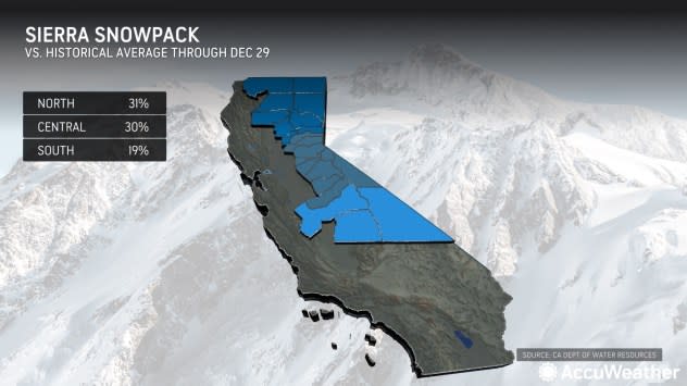
The mountain snow could prove a boon to ski resorts in the Sierra, where total snow versus the historical average-to-date is lacking, but travel through the passes in the mountain range could prove tricky. Temperatures are expected to be low enough to cause snow to fall at pass levels between 5,000 and 7,500 feet, including Interstate 80's Donner Pass.
 |
"The storm can produce a quick burst of snow over the Sierra, with snow rates of 2-4 inches per hour possible," said AccuWeather Senior Meteorologist Alex Sosnowski. "This would be the first such event like that of the season, so it could catch motorists off guard."
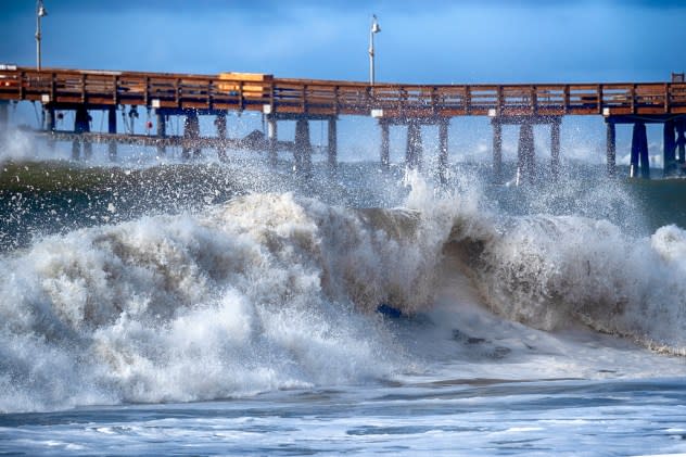
At the coast, a continued threat of rough surf, tremendously high waves and coastal flooding will remain. Last week, many onlookers were caught off guard and even swept off their feet by "sneaker" waves that pushed ashore. The same mechanism that caused the waves-massive storms spinning over the northern Pacific Ocean sending swells toward the West coast-will exist this week, keeping concerns for such conditions elevated.
As the National Weather Service office in San Francisco put it in their forecast discussion on Monday morning, "Never turn your back on the ocean!"
 |
Turbulent large waves break near the Ventura Pier, Saturday, Dec. 30, 2023 in Ventura, Calif. Similar waves overran beaches elsewhere on the California coast, flooding parking lots, streets and triggering evacuation warnings for low-lying areas. (AP Photo/Richard Vogel) |
The heaviest rain and snow in California moved out of the area by late Wednesday as the storm moved farther inland.
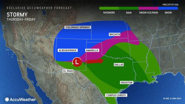
"As the storm shifts inland, rain and mountain snow are expected to spread into Nevada and the Four Corners region (Arizona, Colorado, New Mexico and Utah) through Thursday," added Buckingham. "Beyond that, the next phase of the storm will take shape across the southern Plains and then South later in the week."
 |
By this weekend, this same storm will produce the first widespread, significant winter storm threat of the season across the mid-Atlantic and Northeast.
Following a brief break for the middle of the week, the next storm will already be gathering steam and moisture offshore in the Pacific Ocean and will set its sights on the West by late week.
"There will only be a short period of dry conditions along the West coast and into the Southwest in the wake of this storm," said Buckingham. "Another storm will aim at the region into the upcoming weekend."
The next storm may actually come in two fast-moving waves. The first one looks to spare much of Central and Southern California while delivering locally heavy rain and snow to Northern California and the Northwest, including the Cascades and northern Sierra from late Thursday night through Friday. This storm will bring the heaviest rain of the week to places such as Portland and Seattle, along with potentially damaging winds along the Oregon and Washington coastlines.
The second wave looks to aim farther south, bringing a return of rain to Central and Southern California and into the Great Basin region as the first weekend of 2024 gets underway. Chillier air expected to accompany that storm could lower snow levels across much of the West and potentially impact the walk on the red carpet before the 2024 Golden Globe Awards ceremony in Beverly Hills on Sunday evening.
 |
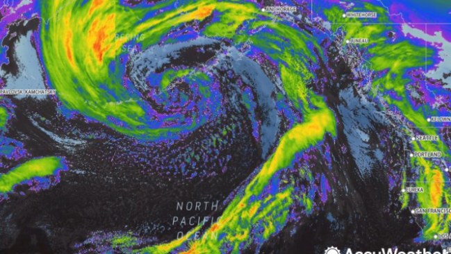
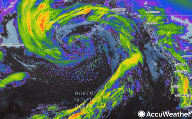
The next storm to impact the West Coast, as seen over the Northern Pacific Ocean on AccuWeather RealVue™ Enhanced Satellite on Tuesday night, Jan. 2, 2024. |
Yet another, and perhaps final, storm will then move through sometime during the early and middle part of next week, capping what will be a wet and snowy start to 2024. Following that, AccuWeather's team of long-range forecasters expect a pattern change.
"An area of high pressure pushing into the eastern Pacific near the West Coast around the middle of next week may force a change where most of the storms will cut inland across the interior West, rather than impacting areas near the coast," said AccuWeather's Lead Long-Range Forecaster Paul Pastelok. "This would result in less precipitation near the coast and big cities, and perhaps more importantly, an ease up on the wave action."
Want next-level safety, ad-free? Unlock advanced, hyperlocal severe weather alerts when you subscribe to Premium+ on the AccuWeather app. AccuWeather Alerts™ are prompted by our expert meteorologists who monitor and analyze dangerous weather risks 24/7 to keep you and your family safer.
