Parts of Fort Collins got more than 2 inches of rain overnight. Here's what to expect Thursday.
Parts of Fort Collins got more than 2 inches of rain as lightning flashed and thunder crashed overnight into Thursday morning, with more expected in Thursday's forecast.
While the official Fort Collins weather station at Colorado State University recorded 1.65 inches of rainfall starting Wednesday night, reports to the Community Collaborative Rain, Snow and Hail Network, or CoCoRaHS, on Thursday morning showed up to 2.55 inches of precipitation reported in Fort Collins proper and up to 2.62 inches in Wellington.
A small storm system started around 9:30 p.m. Wednesday, lasting until 11 p.m. before hitting again at around 1:50 a.m. Thursday. Substantial rain, lightning and wind continued until around 5:50 a.m., with peak winds reaching 23 miles per hour around 4:30 a.m., according to the Fort Collins weather station's Thursday morning update.
Thursday's live updates:Fort Collins experiencing heavy rain
Rain wasn't the only thing to impact Wellington and other portions of Larimer County. Damaging hail hit the town prior to 9 p.m. Wednesday, as hail stones the size of grapes and larger pelted roofs, cars and anything left outside. Photos on social media and sent to Coloradoan staff showed hailstones the size of walnuts in the affected area.
The chaos of Wednesday night was evident in precipitation reports submitted to CoCoRaHS on Thursday.
"Lots and Lots of hail! Biggest stone collected was 2.25 (inches)," said a participant who reported the 2.62 inches of rain east of I-25 in Wellington on Thursday morning. "Fence damage, broken windows, dents in siding, car dents and broken windshields. Hail report submitted."
Another CoCoRaHS participant who reported 2.48 inches of precipitation west of I-25 in Wellington on Thursday morning wrote: "Yes, that is all of the rain! Household member deployed hail pad around 7:30 pm ... golf ball sized hail, ... . I arrived back around 8:30 (to see) only .10 in gage. After that, multiple rains."
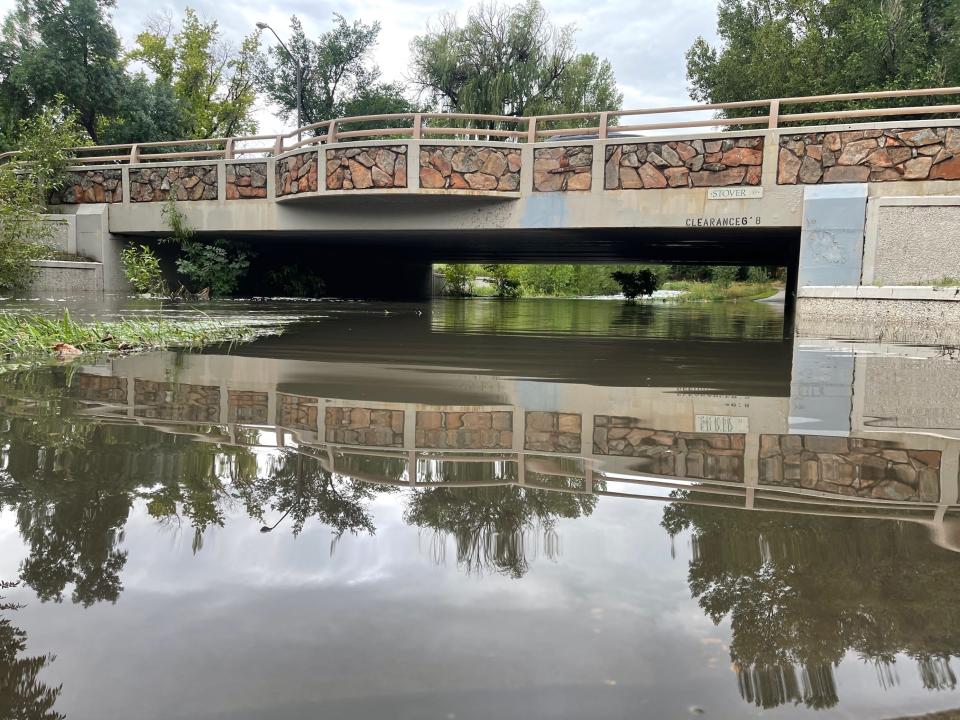
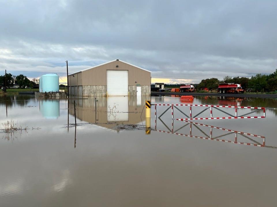
Coloradoan journalists witnessed multiple flooded areas in Fort Collins and along the I-25 corridor Thursday morning.
Weather watching network got its start because of 1997 flood
The CoCoRAHS network was created in response to the 1997 Spring Creek Flood, which occurred 25 years ago Thursday.
At the time, then-state climatologist Nolan Doesken wanted to understand how the event unfolded, so he coordinated rainfall reports across the city, gathering about 300, according to previous Coloradoan reporting.
He found the totals were widely different, from 6 inches of rainfall at the official weather station at Colorado State University to 10 to 14.5 inches reported on the west side of Fort Collins and about 2 inches on the east side, over the course of about 30 hours.
Doesken then created CoCoRAHS to correlate weather radar estimates of rainfall amounts with what happens on the ground.
Volunteers use rain gauges, aluminum-wrapped hail pads and rulers to measure precipitation. They report the information through the program’s website, maintained by the Colorado Climate Center at CSU.
It's made an impact nationwide. Since 1998, CoCoRaHS has spread to all 50 states and the District of Columbia, Puerto Rico, Canada and the Bahamas.
Track rainfall through city rainfall and stream monitoring
While CoCoRAHS reports come in each morning, you can get a sense of more recent rainfall intensity through the city of Fort Collins' flood warning system.
The system alerts emergency preparedness teams when gauges record stream flow depths or rainfall that exceeds certain thresholds, according to the city website.
This system was also set up because of the Spring Creek Flood. FEMA grants and Fort Collins Utilities stormwater funding helped build out the network of stream and rainfall gauges. Today there are 55 rain sensors, 40 stream sensors, six weather stations and two water quality monitoring locations, according to the city of Fort Collins.
You can find the rainfall and streamflow gauge maps at www.fcgov.com/utilities/what-we-do/stormwater/flooding/warning-system. There, you can change time intervals ranging from the past 30 minutes up to 30 days.
The map shows what it looked like at noon Thursday for the previous 12 hours:
Fort Collins forecast for Thursday
Showers and thunderstorms are expected to impact Fort Collins and Larimer County throughout Thursday, with the Fort Collins weather station forecasting another storm system developing in the morning hours.
The highest chance for precipitation in Fort Collins on Thursday is during the day, when the weather service forecast predicts an 80% chance of precipitation. There's a 60% chance of precipitation between 9 p.m. and midnight, and a slight chance of showers and thunderstorms after midnight, according to the weather service forecast.
More:Signing up for these Larimer County emergency alerts could save your life
Flash flood watch in effect Thursday
A flash flood watch goes into effect starting Thursday morning for wildfire burn areas in Northern Colorado.
The National Weather Service in Boulder issued the watch on Wednesday, to begin at 11 a.m. Thursday and last through 10 p.m.
That watch includes the East Troublesome, Cameron Peak, Williams Fork and Calwood burn scars and warns that more heavy rain could trigger flash flooding and debris flows.
More:Heat advisory? Special weather statement? Here's what these weather watches, warnings mean
"If you are traveling into these areas tomorrow, stay weather aware!" the weather service's Boulder office posted on Twitter on Wednesday.
"Residents in and immediately next to recent burn scars should prepare for potential flooding impacts," the weather service stated in another post. "Be ready to act and move to higher ground should a Flash Flood Warning be issued for your location."
A Flash Flood Watch has been issued for late Thursday AM through Thursday evening. Heavy rain could cause flash flooding across the Cameron Peak, East Troublesome, Calwood, and Williams Fork burn areas. If you are traveling into these areas tomorrow, stay weather aware! #cowx pic.twitter.com/Tg0HNG3gi3
— NWS Boulder (@NWSBoulder) July 27, 2022
Coloradoan reporter Miles Blumhardt contributed to this report.
This article originally appeared on Fort Collins Coloradoan: Fort Collins rain totals, forecast after night of thunderstorms

