Which parts of Stanislaus County are most at risk for earthquakes? Here are tips to stay safe
At least six earthquakes were recorded in western Stanislaus County Monday afternoon through early Tuesday morning, and some Modesto-area residents said they felt at least one of them.
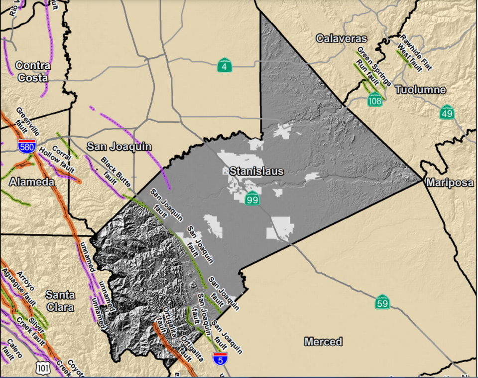
Several faults run through Stanislaus County, including the Great Valley thrust fault system. The series of lines runs along the west side of the San Joaquin Valley, said Belle Philibosian, a research geologist with the United States Geological Survey.
“This particular earthquake, it’s hard to say exactly which fault line it’s on,” Philibosian said. “It may not be associated with any of the major known, mapped fault lines.”
Here are the earthquakes that happened in Stanislaus County in September 2023, which parts of the county are most at risk and what officials say to do if you feel one:
Where are the faults in Stanislaus County?
The San Joaquin and Ortigalita fault lines are part of the Great Valley thrust fault system, Philibosian said.
The earthquakes this week were located slightly north of the Ortigalita fault, in an area without any mapped fault lines at the surface, she said.
“These earthquakes, of course, occurred some miles deep in the earth,” Philibosian said. “I would hesitate to associate these earthquakes with any one of those particular mapped faults, but they’re happening on that broader fault zone.”
In the southern area of the Diablo Range, an area west of I-5, is the Ortigalita fault. Most construction in this area is prohibited without a geographic study, according to the county.
No active faults are currently known to exist within the valley portion of the county, a 2017 version of the county’s hazard mitigation plan says.
Most development in the unincorporated county is not near the areas of greatest shaking potential, according to the county, with exception of the Diablo Grande community.
All of the recent earthquakes were in the area of Diablo Grande and Westley.
“This seems to be part of a longer sequence that started on Aug. 25,” Philibosian said. “Most of the earthquakes have been quite small and probably not felt. The activity really ramped up after that magnitude 4 last night.”
Here are the locations and sizes of the earthquakes, according to previous Bee reporting:
5:15 p.m. (4.0)- 14 km south-southwest of Westley, at a depth of 0.1 km
8:44 p.m. (3.6)- 15 km southwest of Westley, depth imprecise
9:13 p.m. (4.5)- 15 km southwest of Westley, at a depth of 3.5 km
9:40 p.m. (3.2)- 16 km west-southwest of Patterson at a depth of 1.4 km
10:25 p.m. (3.2)- 17 km west-southwest of Patterson at a depth of 1.9 km
3:21 a.m. (3.1)- 16 km west-southwest of Patterson at a depth of 0.3 km
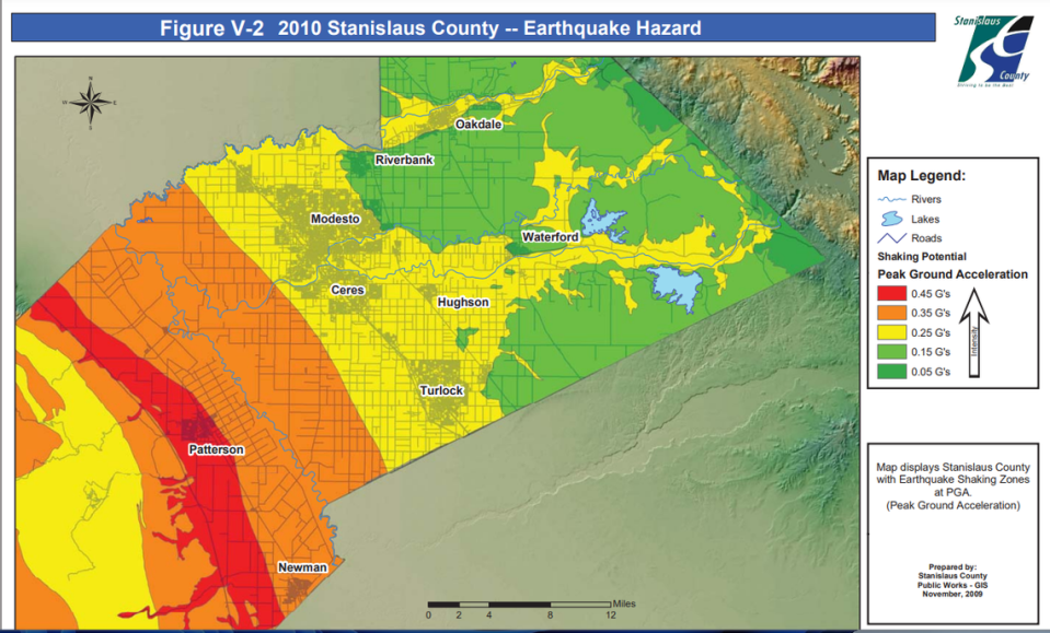
How common are earthquakes in Stanislaus County and where is the risk?
The area is no stranger to small earthquakes, Philibosian said. Since the 1970s when there were instruments to record them in Stanislaus County, there have been dozens of similarly sized earthquakes.
Monday’s magnitude 4.5 temblor was the largest earthquake ever recorded by instruments in the county, Philibosian said.
The western region of Stanislaus County — like Diablo Grande and Westley that experienced Monday and Tuesday’s quakes — has more earthquakes than the eastern part.
What triggers an earthquake and how are they measured? A California physicist answers
The active faults that may cause ground shaking in the county include the San Andreas, Calaveras and Hayward faults, according to the county.
Damage from earthquakes hasn’t occurred for over 200 years, according to the county, except for two occurrences in the extreme western region that borders Santa Clara County. Stanislaus County has declared no disasters caused by earthquake since 1950, the hazard plan states.
While the effects of an earthquake on Stanislaus County’s fault lines lessen in the more incorporated parts of the county — like Modesto — the dangers from a large earthquake in the region are present.
Stanislaus County is not expected to be an epicenter for a major earthquake, the county states, but damage could result from shaking and aftershocks in other areas. All of California is at high risk for earthquakes.
There is an 80.62% chance of a major earthquake within 31 miles of Stanislaus County within the next 50 years, according to the 2017 hazard plan, and the probability of one impacting the region is likely.
What to do during an earthquake
Even areas that seem relatively quiet — like Stanislaus County — are not without risk of an earthquake, Philibosian said.
“The way to avoid panic is to think about the possibility of these events happening in advance and then you can take steps to be prepared so that you don’t suffer injury or damage,” she said.
StanEmergency offers several tips for what to do during an earthquake, including:
Stay inside
Minimize movement
Take cover and hold on to what’s near you
Stay away from glass, windows or anything that can fall
If you’re in bed, stay there and cover your head with a pillow
Cover your face and head and crouch in an inside corner
If you are outside, stay there and move away from buildings, street lights and utility wires
If you’re in a vehicle, stop and stay put
Do not use elevators
The Bee’s Deke Farrow contributed to this story.
What do you want to know about life in Modesto? Ask our service journalism team your top-of-mind questions in the module below or email servicejournalists@modbee.com.

