It’s the peak of storm season and the hurricane center is tracking six systems
The meteorological peak of hurricane season is Sept. 10, and it sure looks like it in the Atlantic basin.
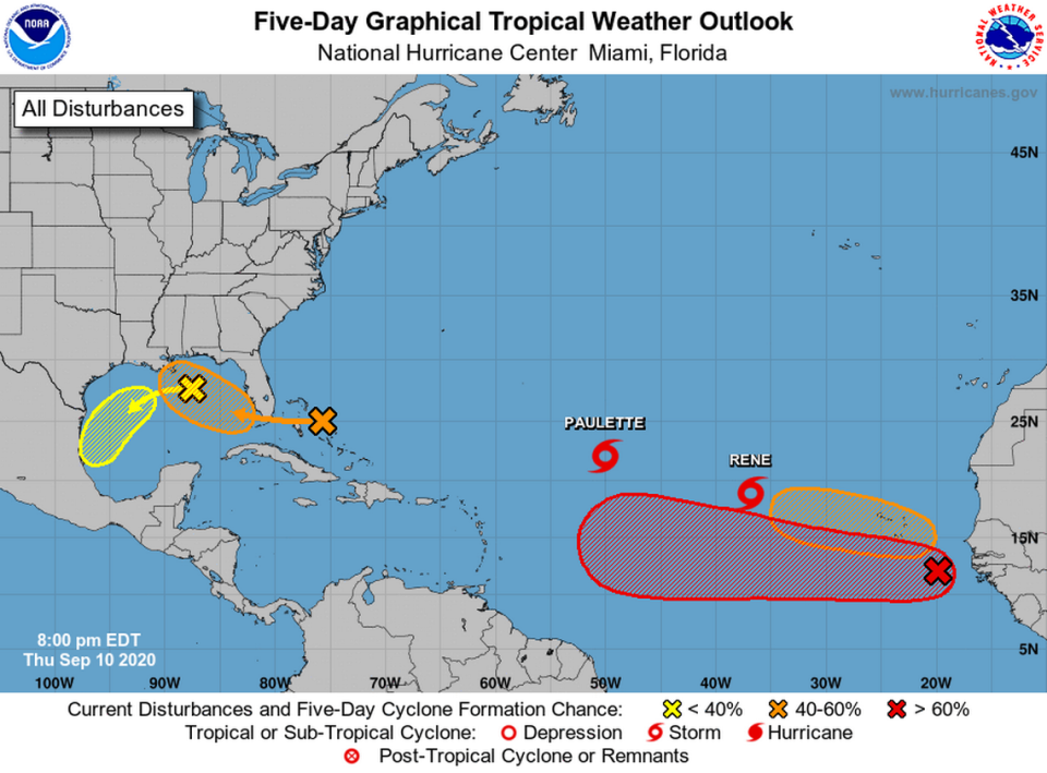
The National Hurricane Center is tracking six systems, with the newest one added at the 8 a.m. update. Two of them are tropical storms, and one is poised to strike Bermuda.
The closest system to Florida is an area of low pressure a couple of hundred miles northeast of the Central Bahamas. Forecasters expect the system to cross the Bahamas and Florida on Friday before moving into the Gulf of Mexico over the weekend. It has a 50% chance of developing into anything stronger during that time.
The newest system, another low pressure area, popped up in the Gulf on Thursday morning. The hurricane center said it could move west and south for the next few days without much chance of development — 10% in the next two days and 20% in the next five.
The hurricane center stopped tracking a trough of low pressure hovering near North Carolina as of the 2 p.m. update.
‘More heat, less Florida’: Advocates draw attention to climate change’s main impact
Meanwhile, forecasters have ratcheted up the chances of formation for the tropical wave that’s been moving off the coast of Africa this week. Now it has a 90% chance of turning into a tropical depression this weekend as it moves west. Chances of formation in the next two days are medium at 60%.
The final wave (for now) had yet to emerge from Africa’s coast Thursday morning. But when it does, the hurricane center will find favorable conditions for growth and could form a tropical depression early next week. The center gave it a 40% chance of formation in the next five days.
The next two storm names are Sally and Teddy. Once the hurricane center hits the final name, Wilfred, storms will be named after Greek letters.
Although Sept. 10 is the statistical peak of the hurricane season, the National Weather Service of Miami pointed out that “this date bears little significance for mainland South Florida,” because most of the hurricanes that made landfall here occur after this peak. The local peak, the service said, is more like Oct. 20.
And then there are the tropical storms.
Tropical Storms Paulette and Rene were in the center of the Atlantic Ocean, far from most land, and were forecast to strengthen into Category 1 hurricanes in the next few days.
As of 11 p.m. Thursday, Paulette strengthened and was expected to become a hurricane this weekend.
Paulette was moving northwest near 10 mph with maximum sustained winds near 60 mph with higher gusts. The tropical storm was about 850 miles east-northeast of the Northern Leeward Islands and about 1,075 miles southeast of Bermuda. Its tropical-storm-force winds extended up to 205 miles from the center.
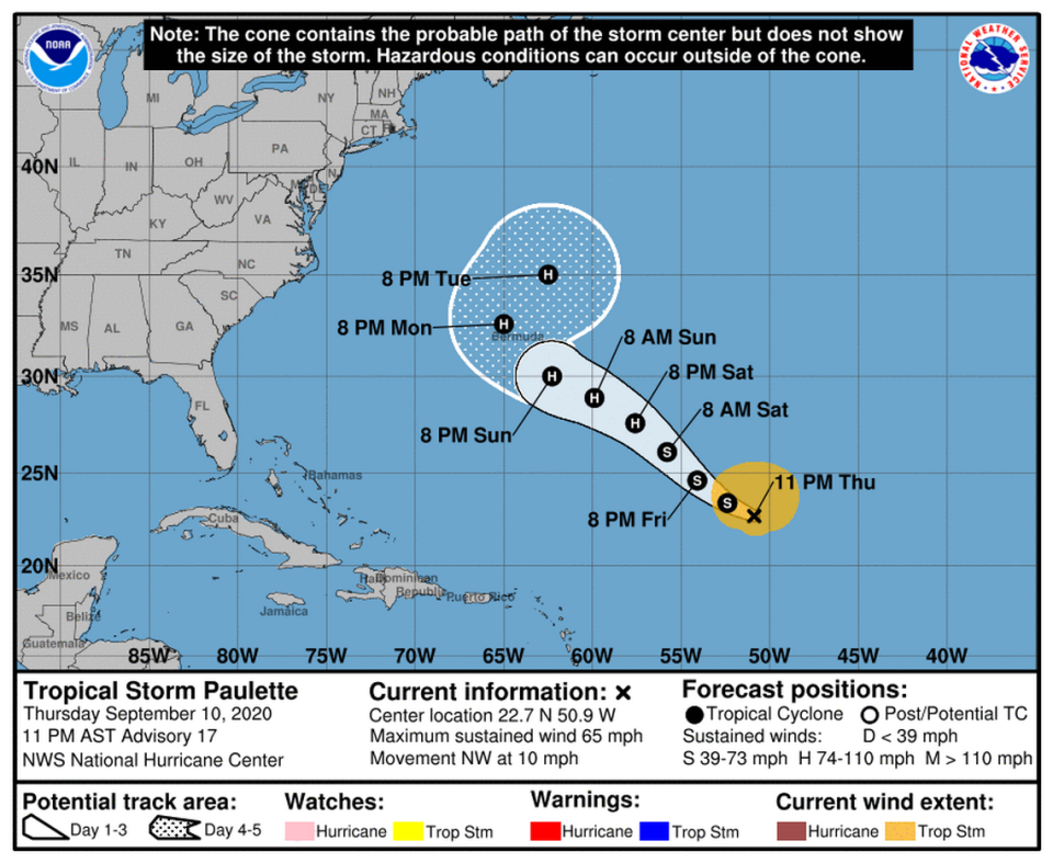
Forecasters say those with interests in Bermuda should continue monitoring the storm’s progress. Swells caused by Paulette were also forecast to reach portions of the Leeward Islands Thursday night and Friday and spread westward to portions of the Greater Antilles, Bahamas and Bermuda into the weekend. These swells will likely cause life-threatening surf and rip current conditions, according to the hurricane center.
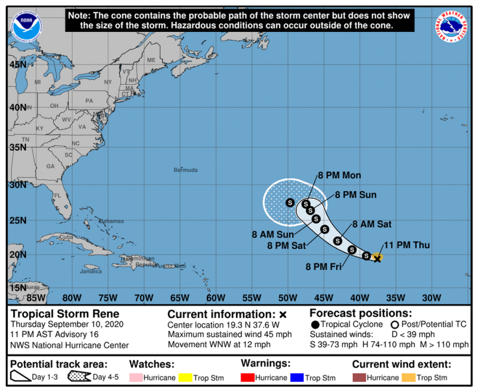
Tropical Storm Rene continued to move west-northwestward across the Atlantic near at 12 mph. It was about 925 miles west-northwest of the Cabo Verde Islands Thursday night. The storm’s maximum sustained winds were near 45 mph with higher gusts, according to the hurricane center.
Rene’s forecast no longer showed it briefly becoming a Category 1 hurricane.