Pensacola facing another round of severe weather on Friday; temps in 20s next week
The Pensacola area will face the risk of severe weather again on Friday, with the chance of damaging winds of 70 mph, tornadoes and large hail.
The National Weather Service's Storm Prediction Center has placed the Pensacola region under a "slight" severe weather risk, level two out of five, on Friday.
The system could bring a repeat of the storms that moved through the area early Tuesday morning.
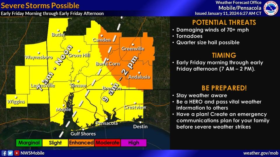
This system is expected to move into the area Friday morning sometime after 9 a.m. and should clear the area by 2 p.m.
The National Weather Service office in Mobile, Alabama, said that outside of the risk of severe weather, very windy conditions between 20-30 mph will develop across the area. Additionally, strong on-shore winds will create high surf of between 5 to 8 feet.
A line of severe storms moved through the area on Tuesday causing damage, especially in Walton and Bay counties. Gov. Ron DeSantis declared a state of emergency as a result of the storms moving through the area.
Over in Santa Rosa County, Florida an EF1 tornado occurred on Escribano Point with winds upwards of 105mph and a path length of 0.39 miles, path width is 75 yards. It is possible the path was longer and will require review of available satellite imagery 4/9 pic.twitter.com/o5FCwSTj7r
— NWS Mobile (@NWSMobile) January 11, 2024
Survey teams from the weather service office in Mobile confirmed that Santa Rosa County experienced an EF-1 tornado in an uninhabited area in the Escribano Point Wildlife Management Area. The tornado lasted about a minute and traveled 0.39 miles, reaching winds of 105 mph.
Additionally, the weather service said an area in North Santa Rosa County near Berrydale had significant straight-line wind damage that reached 100 mph and caused a swath of damage 250 yards wide for 1.8 miles.
Looking ahead to next week, much of the nation will see a surge of Artic air. The weather service office in Mobile is monitoring how the air mass will affect the Pensacola area. A front is expected to move through the area Monday, bringing a chance of rain.
Further north in Santa Rosa County, Florida, a significant swath of straight-line wind damage occurred with peak winds estimated at 100mph. This swath was approximately 250 yards in width and occurred intermittently for nearly 1.8 miles. 5/9 pic.twitter.com/gKMmbLFuPg
— NWS Mobile (@NWSMobile) January 11, 2024
As of Friday, forecasters at the weather service said there is a chance for a light wintry mix of interior areas, but it will likely be very light and isolated.
Temperatures on Tuesday night are expected to plummet into the low 20s and will struggle to make it out of the 30s during the day on Wednesday.
This article originally appeared on Pensacola News Journal: Pensacola severe weather Friday has tornadoes, hail, wind in forecast

