Pensacola saw its hottest July ever — again — after tying with a 23-year-old record
Pensacola is one of several Florida cities that tied its hottest July on record set in 2000 after hitting an average monthly temperature of 85.5 degrees, 2.2 degrees above normal.
July climate summaries from the National Weather Service and the Florida Climate Center painted an alarming picture as many places around the state experienced their top five hottest Julys on record.
Average monthly temperatures across the state were above normal, with increases ranging from 0.7-3 degrees. The highest temperature recorded in Pensacola for the month was 99 degrees, which occurred on July 30 and was just above 7 degrees higher than the normal daily high for that date.
August climate outlook: Most Florida cities saw their top 5 hottest Julys on record. August doesn't look any better.
Two record high "low temperatures" were observed on July 1 and 3. On July 1, the daily low was 81 degrees, tying as the hottest low observed on that date since 1932. Low temperatures on July 3 hit 82 degrees, which tied the previous record not seen on this date since 1897.
The lowest temperature recorded for the month was 74 degrees, which happened on July 16 and 31, which is 5 degrees lower than the normal daily low for those two days.
Most places in Florida saw their top five hottest Julys on record
Most places across Florida experienced one of their top five hottest Julys on record as many cities experienced triple-digit temps and oppressive humidity, and others felt those effects compounded by extreme drought.
Average monthly temperatures in July were above normal throughout Florida, according to the Florida Climate Center’s July summary.
Several cities saw their hottest July on record, including Pensacola, Jacksonville, Tampa, Sarasota, Vero Beach, Fort Myers, Naples, Miami and Key West, based on their monthly average temperatures.
Safest Florida cities for hurricanes: What are safest cities in Florida when it comes to hurricanes? Some may surprise you
In South Florida, Miami reached a heat index of over 110 degrees on two days. It set a new record after seeing a heat index over 100 degrees for 46 consecutive days.
Meanwhile, monthly precipitation in the state swung wildly between -6.29 inches in places like Sarasota to +5.91 inches in West Palm Beach.
The Sarasota-Bradenton area had its second-driest July on record and Naples had its third-driest July on record. Melbourne had its second-wettest July on record, Vero Beach saw its third-wettest and Fort Lauderdale had its fifth-wettest July on record.
Fort Lauderdale has had its wettest year on record to date, while the Sarasota-Bradenton area has had its driest year on record so far, where the year-to-date rainfall deficit stands at 20.68 inches.
Florida’s August climate outlook
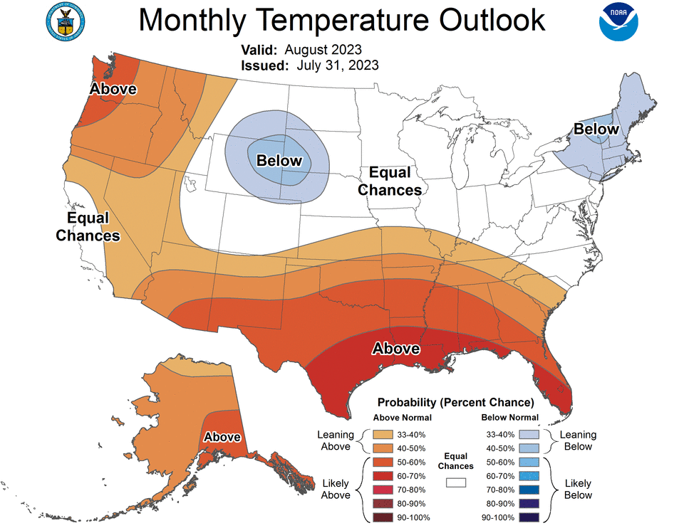
The Climate Prediction Center at the National Oceanic and Atmospheric Administration published its August temperature outlook and predicts that above-average heat is here to stay for the remainder of summer.
The updated outlook shows southern and western parts of the country are likely to continue seeing well above-normal temperatures while the western high Plains and parts of the Northeast are favored to see well below-average temperatures.
Areas like Texas and Arizona, which have seen the hottest temperatures, have a 60-70% chance to see well above-average temperatures for most of August. Areas along the Gulf Coast are just as likely to see well above-average temperatures. In Florida, the most impacted areas are the Panhandle and parts of South Florida that are also seeing well above-normal sea surface temperatures.
Climate Point: July heat had 'the fingerprints of climate change'
How to read the map
NOAA’s monthly climate outlook maps look simple but can occasionally be tricky to navigate. Here’s how to interpret it.
White areas
Areas represented in white mean there are equal chances for all three possible outlook categories: well above average, near average and well below average. This means that white areas do not represent an average or typical month.
Blue areas
Areas represented in blue signal that the Climate Prediction Center anticipates a much cooler-than-average month rather than a near-average or much warmer-than-average month. Darker hues indicate that the chances for a relatively cold month are higher — not an indicator of extreme cold.
Orange/red areas
Areas represented in orange are more likely to be much warmer than a near-average or much cooler-than-average month. Darker hues indicate that the chances for a relatively warm month are higher — not an indicator of extreme heat.
This article originally appeared on Pensacola News Journal: Pensacola July heat ties for hottest on record, breaks 2 daily records

