Perilous blizzard to thrash Midwest followed by dangerous flash freeze

As AccuWeather meteorologists predicted, a winter storm rapidly strengthened and slowed down travel in much of the Midwest due to blizzard conditions, heavy snow accumulation, strong winds, extensive blowing and drifting snow and plummeting temperatures.
This major storm unfolded just three to four days after a big winter storm walloped much of the region.
Although the snow will come to an end on Saturday for some, frigid air and brutal winds will still create dangerous and life-threatening AccuWeather RealFeel® Temperatures for people and animals caught outdoors.
A storm that is poised to become stronger and much colder than the massive storm that hit the central United States from Monday to Tuesday progressed quickly through the interior West at midweek, AccuWeather Chief On-Air Meteorologist Bernie Rayno said.
 |
The storm then turned the corner over the southern Plains on Thursday and will roll across the Midwest into early Saturday.
While the storm's central pressure decreased 13 millibars between Thursday evening and Friday evening, it did not quite undergo bombogenesis or become a bomb cyclone. The official designation for such a storm occurs when the barometric pressure drops 0.71 of an inch of mercury (24 millibars) or more within 24 hours. The faster that the pressure drops, the faster that winds rush in to replace the air. Although the storm did not become a bomb cyclone, pressure still dropped quickly enough that winds increased and caused power outages and property damage, as well as near-zero visibility in snow and blowing snow (blizzard).
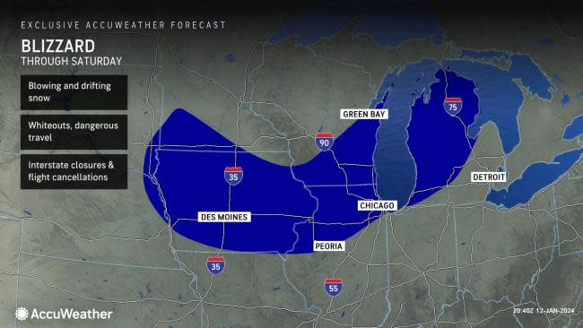
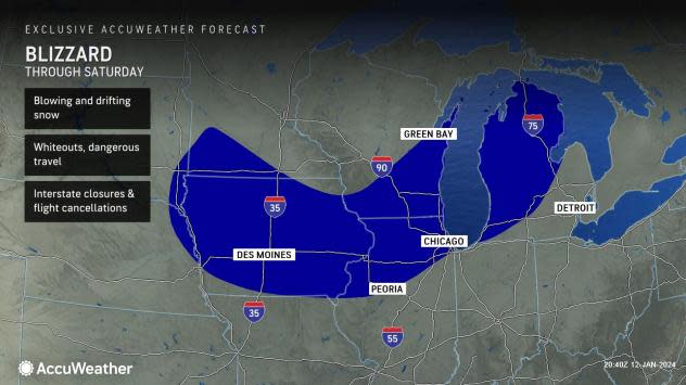
Blizzard conditions may expand to at least a half dozen states and 130,000 square miles of the Midwest, including rural, suburban and major metro areas.
 |
Even though Chicago escaped the storm on Tuesday with a light to moderate amount of snow, it is in the crosshairs of the storm's blizzard conditions through Saturday morning. Travel conditions will remain deteriorated, and travel may be nearly impossible both as the storm rages and in its wake for a time.
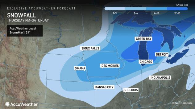
The storm is on track to deliver 4-8 inches of snow to the Chicago lakefront, with 8-12 farther inland. Some neighborhoods may face a scenario where 12-18 inches pile up. Blowing and drifting snow on top of that will result in snowdrifts several feet high that can cause vehicles to be stuck on highways.
Chicago was most recently hit by a blizzard in 2015. Other infamous winter storms that hit the city struck in 2011, 1999, 1979, and 1967.
 |
I-80 in Omaha, NE experienced a reported shutdown due to blizzard conditions and a multitude of accidents brought on by the wintry conditions. I-70, located in Kansas City, MO also experienced a shut down, as multiple vehicle accidents and wintry travel conditions were reported.
 |
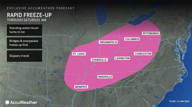
As Arctic air blasts in during the second half of the storm and in its wake, plunging temperatures will quickly cause slush and standing water to freeze over portions of the middle Mississippi and Ohio valleys, as well as the Great Lakes region. Temperatures are forecast to crash into the teens, single digits and even below zero F in the wake of the storm this weekend over a large portion of the Central states.
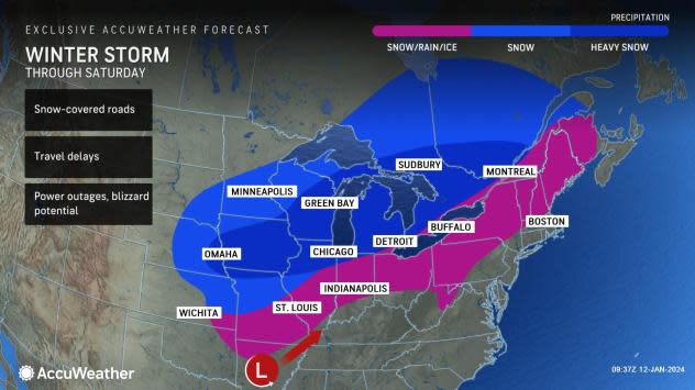
After heavy snow and strong winds to targeted many major hubs in the Midwest, including Chicago, Detroit, St. Louis and Kansas City, Missouri, as well as heavy rain, thunderstorms and strong winds impacting the major hubs of Atlanta, Charlotte, Philadelphia, New York City and others in the East and South, flight delays and cancellations will abound by Saturday. Keeping aircraft and runways free of snow and ice during the storm could be difficult in parts of the Midwest.
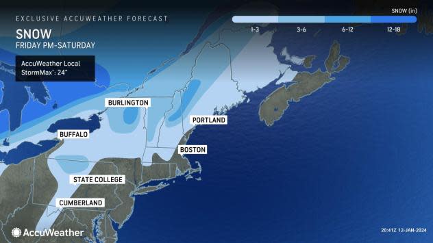
The storm will have wintry impacts over the interior Northeast into Saturday. Several inches of snow or a wintry mix can make roads slippery from the central Appalachians to northern New England.
A new round of heavy rain and gusty winds will affect many East areas with new surges of high water on area streams and rivers this weekend. The same storm system will trigger severe weather and more tornadoes through Friday evening in the Southeast states.
 |
"Winds on the back side of the massive storm may be stronger, more extensive and longer lasting in the Midwest and Northeast than from the storm to start the week," AccuWeather Senior Meteorologist Joe Lundberg said.
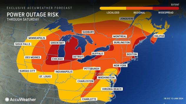
In areas hit by mostly rain thus far this winter, or where the last storm brought a rapid thaw, the risk of trees toppling over in the soggy ground will be high. Where the power goes out, plunging temperatures may leave hundreds of thousands of people in the cold and the dark this weekend.
Every state along and east of the Mississippi River will be at risk for power outages from the storm through Saturday. As of early Saturday morning, more than 360,000 utility customers were already without power, according to PowerOutage.us, even though the storm was far from its peak intensity.
 |
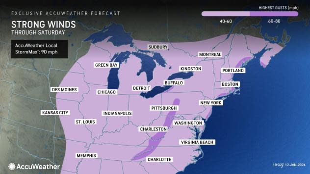
The storm will produce widespread wind gusts ranging from 40-60 mph, which alone is capable of knocking over trees when the soil is dry or causing large tree limbs to come crashing down.
When trees come down, power lines often come with them. In some cases, such as near the eastern shores of Lake Erie, within the higher terrain of the Appalachians and along the upper mid-Atlantic and New England coasts, gusts ranging from 60-80 mph are likely with an AccuWeather Local StormMax™ gust of 90 mph.
 |
Even in the area where all or mostly snow falls, the clinging nature of the snow, especially around Lake Michigan, will make many trees vulnerable to coming down.
The strong winds around the storm will lead to lakeshore flooding and, eventually, freezing spray. As cold air wraps around the Great Lakes region this weekend, bands of exceptionally heavy lake-effect snow will unfold and could affect cities such as Buffalo, New York.
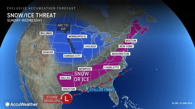
The frigid air in the wake of the storm will penetrate deep into the South and push toward the Atlantic coast.
There is the potential for frozen pipes and water main breaks in the Southern states, and one or more storms with snow and ice are likely to create difficult to dangerous travel in the South and East starting late this weekend and continuing well into next week.
 |
It is possible that the snow drought of an inch or more may not only come to an end in portions of the I-95 in the mid-Atlantic but that snowfall from one or more storms may put seasonal totals back on track.
Want next-level safety, ad-free? Unlock advanced, hyperlocal severe weather alerts when you subscribe to Premium+ on the AccuWeather app. AccuWeather Alerts™ are prompted by our expert meteorologists who monitor and analyze dangerous weather risks 24/7 to keep you and your family safer.
