PHOTOS: Winds bring major power outages in B.C. amid disruptive storm
Waking up in the dark with no electricity was not the start to the weekend thousands of B.C. residents were hoping for, but that's what they got.
DON'T MISS: These winter driving hacks can save you some trouble (and time)
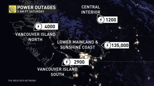
Early on Saturday morning, a strong cold front swept across the South Coast, causing power outages for well in excess of 100,000 BC Hydro customers.
As of early Saturday morning, more than 130,000 customers are without power on the South Coast, according to BC Hydro. While the numbers have decreased, they may continue to fluctuate during the day.
CBC News also reported that nearly 20 ferry sailings between the mainland and Vancouver Island were cancelled Friday evening as a result.
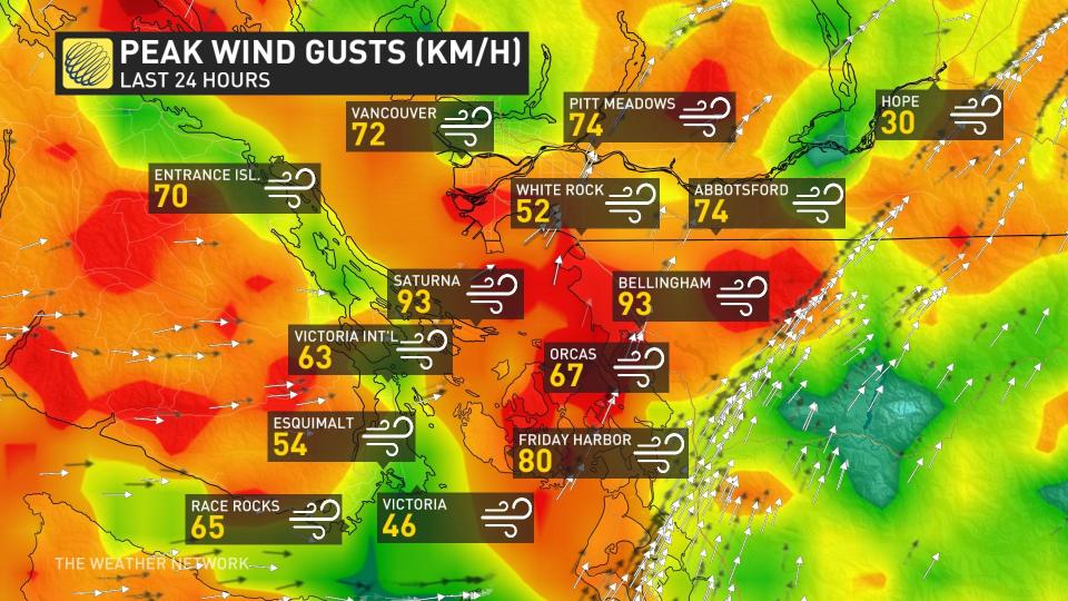
Although it was not a deep low-pressure system, the strong, southerly winds ahead of the trailing cold front peaked in the waters of Georgia Strait and up Howe Sound, with wind gusts exceeding 100 km/h.
Vancouver International Airport recorded a wind gust of 72 km/h, which was the strongest since last November when a gust of 94 km/h occurred on Nov. 4.
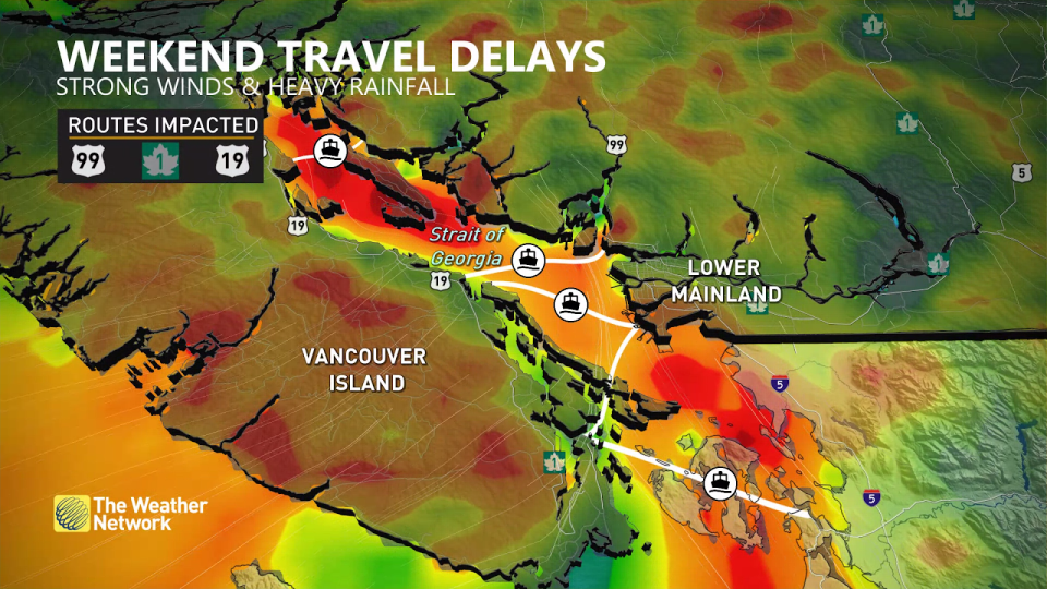
Residents are also urged to brace for travel disruptions, particularly along the highway passes that are expecting heavy snow, and more ferry cancellations. Drivers should expect slower-than-usual commutes and are urged to plan ahead for rapidly changing conditions.
In addition to the winds, soaking rains are expected for the coast. Rainfall rates will approach 10 mm per hour across western Vancouver Island. Rainfall totals will stack up, up to 100 mm for Tofino and 20-60 mm to the Lower Mainland through the event.
A dip in freezing levels below 1200 metres will also bring the opportunity for significant snowfall along the coastal mountains. Folks throughout the coastal alpine regions could see more than 50 cm of snow through Saturday, which will serve as a tremendous boon for ski resorts and winter sports fans looking to get out this weekend.
However, the glut of snow will make for difficult travel along the highway passes. Pack extra supplies and prepare for slow going if you have to travel through the region.
The intensity of the system will diminish through Saturday, but another storm arriving soon after on Sunday will mark the return of active weather.
It didn't take long for visuals of the storm's impacts to appear on social media. Below is a selection of visuals currently making the rounds.
The @BCFerries #HorseshoeBay #Ferry terminal sign bouncing in heavy rain & gusty winds as they flow down the valley at the westernmost mainland terminus of #BChwy1/#TransCanadaHwy.1:30a PT#ShareYourWeather #BCwind #BCrain #BCwx #BCstorm pic.twitter.com/cIuZdTBSzs
The Ryan Voutilainen 🇨🇦🇫🇮 on Twitter: "The @BCFerries #HorseshoeBay #Ferry terminal sign bouncing in heavy rain & gusty winds as they flow down the valley at the westernmost mainland terminus of #BChwy1/#TransCanadaHwy.1:30a PT#ShareYourWeather #BCwind #BCrain #BCwx #BCstorm pic.twitter.com/cIuZdTBSzs / Twitter" Ryan Voutilainen 🇨🇦🇫🇮 on Twitter: "The @BCFerries #HorseshoeBay #Ferry terminal sign bouncing in heavy rain & gusty winds as they flow down the valley at the westernmost mainland terminus of #BChwy1/#TransCanadaHwy.1:30a PT#ShareYourWeather #BCwind #BCrain #BCwx #BCstorm pic.twitter.com/cIuZdTBSzs / Twitter" Ryan Voutilainen 🇨🇦🇫🇮 on Twitter: "The @BCFerries #HorseshoeBay #Ferry terminal sign bouncing in heavy rain & gusty winds as they flow down the valley at the westernmost mainland terminus of #BChwy1/#TransCanadaHwy.1:30a PT#ShareYourWeather #BCwind #BCrain #BCwx #BCstorm pic.twitter.com/cIuZdTBSzs / Twitter" terminal sign bouncing in heavy rain & gusty winds as they flow down the valley at the westernmost mainland terminus of Ryan Voutilainen 🇨🇦🇫🇮 on Twitter: "The @BCFerries #HorseshoeBay #Ferry terminal sign bouncing in heavy rain & gusty winds as they flow down the valley at the westernmost mainland terminus of #BChwy1/#TransCanadaHwy.1:30a PT#ShareYourWeather #BCwind #BCrain #BCwx #BCstorm pic.twitter.com/cIuZdTBSzs / Twitter"/Ryan Voutilainen 🇨🇦🇫🇮 on Twitter: "The @BCFerries #HorseshoeBay #Ferry terminal sign bouncing in heavy rain & gusty winds as they flow down the valley at the westernmost mainland terminus of #BChwy1/#TransCanadaHwy.1:30a PT#ShareYourWeather #BCwind #BCrain #BCwx #BCstorm pic.twitter.com/cIuZdTBSzs / Twitter".
1:30a PTRyan Voutilainen 🇨🇦🇫🇮 on Twitter: "The @BCFerries #HorseshoeBay #Ferry terminal sign bouncing in heavy rain & gusty winds as they flow down the valley at the westernmost mainland terminus of #BChwy1/#TransCanadaHwy.1:30a PT#ShareYourWeather #BCwind #BCrain #BCwx #BCstorm pic.twitter.com/cIuZdTBSzs / Twitter" Ryan Voutilainen 🇨🇦🇫🇮 on Twitter: "The @BCFerries #HorseshoeBay #Ferry terminal sign bouncing in heavy rain & gusty winds as they flow down the valley at the westernmost mainland terminus of #BChwy1/#TransCanadaHwy.1:30a PT#ShareYourWeather #BCwind #BCrain #BCwx #BCstorm pic.twitter.com/cIuZdTBSzs / Twitter" Ryan Voutilainen 🇨🇦🇫🇮 on Twitter: "The @BCFerries #HorseshoeBay #Ferry terminal sign bouncing in heavy rain & gusty winds as they flow down the valley at the westernmost mainland terminus of #BChwy1/#TransCanadaHwy.1:30a PT#ShareYourWeather #BCwind #BCrain #BCwx #BCstorm pic.twitter.com/cIuZdTBSzs / Twitter" Ryan Voutilainen 🇨🇦🇫🇮 on Twitter: "The @BCFerries #HorseshoeBay #Ferry terminal sign bouncing in heavy rain & gusty winds as they flow down the valley at the westernmost mainland terminus of #BChwy1/#TransCanadaHwy.1:30a PT#ShareYourWeather #BCwind #BCrain #BCwx #BCstorm pic.twitter.com/cIuZdTBSzs / Twitter" Ryan Voutilainen 🇨🇦🇫🇮 on Twitter: "The @BCFerries #HorseshoeBay #Ferry terminal sign bouncing in heavy rain & gusty winds as they flow down the valley at the westernmost mainland terminus of #BChwy1/#TransCanadaHwy.1:30a PT#ShareYourWeather #BCwind #BCrain #BCwx #BCstorm pic.twitter.com/cIuZdTBSzs / Twitter" Ryan Voutilainen 🇨🇦🇫🇮 on Twitter: "The @BCFerries #HorseshoeBay #Ferry terminal sign bouncing in heavy rain & gusty winds as they flow down the valley at the westernmost mainland terminus of #BChwy1/#TransCanadaHwy.1:30a PT#ShareYourWeather #BCwind #BCrain #BCwx #BCstorm pic.twitter.com/cIuZdTBSzs / Twitter"— Ryan Voutilainen 🇨🇦🇫🇮 (@RyanVoutilainen) Ryan Voutilainen 🇨🇦🇫🇮 on Twitter: "The @BCFerries #HorseshoeBay #Ferry terminal sign bouncing in heavy rain & gusty winds as they flow down the valley at the westernmost mainland terminus of #BChwy1/#TransCanadaHwy.1:30a PT#ShareYourWeather #BCwind #BCrain #BCwx #BCstorm pic.twitter.com/cIuZdTBSzs / Twitter"
Absolutely Howling at #WestVancouver #BC's #WhytecliffPark! 1215a PT#ShareYourWeather #BCwx #BCwind #BCstorm #YVRwx @weathernetwork @RandySmall pic.twitter.com/r5CvUaMmcb
Absolutely Howling at Ryan Voutilainen 🇨🇦🇫🇮 on Twitter: "Absolutely Howling at #WestVancouver #BC's #WhytecliffPark! 1215a PT#ShareYourWeather #BCwx #BCwind #BCstorm #YVRwx @weathernetwork @RandySmall pic.twitter.com/r5CvUaMmcb / Twitter" Ryan Voutilainen 🇨🇦🇫🇮 on Twitter: "Absolutely Howling at #WestVancouver #BC's #WhytecliffPark! 1215a PT#ShareYourWeather #BCwx #BCwind #BCstorm #YVRwx @weathernetwork @RandySmall pic.twitter.com/r5CvUaMmcb / Twitter"’s Ryan Voutilainen 🇨🇦🇫🇮 on Twitter: "Absolutely Howling at #WestVancouver #BC's #WhytecliffPark! 1215a PT#ShareYourWeather #BCwx #BCwind #BCstorm #YVRwx @weathernetwork @RandySmall pic.twitter.com/r5CvUaMmcb / Twitter"! 1215a PTRyan Voutilainen 🇨🇦🇫🇮 on Twitter: "Absolutely Howling at #WestVancouver #BC's #WhytecliffPark! 1215a PT#ShareYourWeather #BCwx #BCwind #BCstorm #YVRwx @weathernetwork @RandySmall pic.twitter.com/r5CvUaMmcb / Twitter" Ryan Voutilainen 🇨🇦🇫🇮 on Twitter: "Absolutely Howling at #WestVancouver #BC's #WhytecliffPark! 1215a PT#ShareYourWeather #BCwx #BCwind #BCstorm #YVRwx @weathernetwork @RandySmall pic.twitter.com/r5CvUaMmcb / Twitter" Ryan Voutilainen 🇨🇦🇫🇮 on Twitter: "Absolutely Howling at #WestVancouver #BC's #WhytecliffPark! 1215a PT#ShareYourWeather #BCwx #BCwind #BCstorm #YVRwx @weathernetwork @RandySmall pic.twitter.com/r5CvUaMmcb / Twitter" Ryan Voutilainen 🇨🇦🇫🇮 on Twitter: "Absolutely Howling at #WestVancouver #BC's #WhytecliffPark! 1215a PT#ShareYourWeather #BCwx #BCwind #BCstorm #YVRwx @weathernetwork @RandySmall pic.twitter.com/r5CvUaMmcb / Twitter" Ryan Voutilainen 🇨🇦🇫🇮 on Twitter: "Absolutely Howling at #WestVancouver #BC's #WhytecliffPark! 1215a PT#ShareYourWeather #BCwx #BCwind #BCstorm #YVRwx @weathernetwork @RandySmall pic.twitter.com/r5CvUaMmcb / Twitter" Ryan Voutilainen 🇨🇦🇫🇮 on Twitter: "Absolutely Howling at #WestVancouver #BC's #WhytecliffPark! 1215a PT#ShareYourWeather #BCwx #BCwind #BCstorm #YVRwx @weathernetwork @RandySmall pic.twitter.com/r5CvUaMmcb / Twitter" Ryan Voutilainen 🇨🇦🇫🇮 on Twitter: "Absolutely Howling at #WestVancouver #BC's #WhytecliffPark! 1215a PT#ShareYourWeather #BCwx #BCwind #BCstorm #YVRwx @weathernetwork @RandySmall pic.twitter.com/r5CvUaMmcb / Twitter" Ryan Voutilainen 🇨🇦🇫🇮 on Twitter: "Absolutely Howling at #WestVancouver #BC's #WhytecliffPark! 1215a PT#ShareYourWeather #BCwx #BCwind #BCstorm #YVRwx @weathernetwork @RandySmall pic.twitter.com/r5CvUaMmcb / Twitter"
— Ryan Voutilainen 🇨🇦🇫🇮 (@RyanVoutilainen) Ryan Voutilainen 🇨🇦🇫🇮 on Twitter: "Absolutely Howling at #WestVancouver #BC's #WhytecliffPark! 1215a PT#ShareYourWeather #BCwx #BCwind #BCstorm #YVRwx @weathernetwork @RandySmall pic.twitter.com/r5CvUaMmcb / Twitter"
The lightning stood me up but the debris did not. Managed to tow two partial trees off roads and cleared several large branches. What is sleep? #bcstorm #bcstormwatch pic.twitter.com/T5CVBOYzls
The lightning stood me up but the debris did not. Managed to tow two partial trees off roads and cleared several large branches. What is sleep? Gabriel S on Twitter: "The lightning stood me up but the debris did not. Managed to tow two partial trees off roads and cleared several large branches. What is sleep? #bcstorm #bcstormwatch pic.twitter.com/T5CVBOYzls / Twitter" Gabriel S on Twitter: "The lightning stood me up but the debris did not. Managed to tow two partial trees off roads and cleared several large branches. What is sleep? #bcstorm #bcstormwatch pic.twitter.com/T5CVBOYzls / Twitter" Gabriel S on Twitter: "The lightning stood me up but the debris did not. Managed to tow two partial trees off roads and cleared several large branches. What is sleep? #bcstorm #bcstormwatch pic.twitter.com/T5CVBOYzls / Twitter"
Strong winds and howling, #whiterock #bcstorm pic.twitter.com/xmjoIRyTRd
Strong winds and howling, Jijid Aboobacker on Twitter: "Strong winds and howling, #whiterock #bcstorm pic.twitter.com/xmjoIRyTRd / Twitter" Jijid Aboobacker on Twitter: "Strong winds and howling, #whiterock #bcstorm pic.twitter.com/xmjoIRyTRd / Twitter" Jijid Aboobacker on Twitter: "Strong winds and howling, #whiterock #bcstorm pic.twitter.com/xmjoIRyTRd / Twitter"
— Jijid Aboobacker (@Jijid) Jijid Aboobacker on Twitter: "Strong winds and howling, #whiterock #bcstorm pic.twitter.com/xmjoIRyTRd / Twitter"
Apparently lightning hit this pole, leading to a massive power outage from Mussels & More to McDonald's in #CampbellRiver #bcstorm thereby canceling my Skip shift. pic.twitter.com/hkd5if1s1m
Apparently lightning hit this pole, leading to a massive power outage from Mussels & More to McDonald's in Skooch Banachek on Twitter: "Apparently lightning hit this pole, leading to a massive power outage from Mussels & More to McDonald's in #CampbellRiver #bcstorm thereby canceling my Skip shift. pic.twitter.com/hkd5if1s1m / Twitter" Skooch Banachek on Twitter: "Apparently lightning hit this pole, leading to a massive power outage from Mussels & More to McDonald's in #CampbellRiver #bcstorm thereby canceling my Skip shift. pic.twitter.com/hkd5if1s1m / Twitter" thereby canceling my Skip shift. Skooch Banachek on Twitter: "Apparently lightning hit this pole, leading to a massive power outage from Mussels & More to McDonald's in #CampbellRiver #bcstorm thereby canceling my Skip shift. pic.twitter.com/hkd5if1s1m / Twitter"
— Skooch Banachek (@SkoochXC) Skooch Banachek on Twitter: "Apparently lightning hit this pole, leading to a massive power outage from Mussels & More to McDonald's in #CampbellRiver #bcstorm thereby canceling my Skip shift. pic.twitter.com/hkd5if1s1m / Twitter"
Gusts continue to pound Kelowna in excess of 60+ km/h from the SE. #BCStorm #BCwx #BCwindAs soon as it went silent, an audible roar was heard gradually approaching...(winds have since restarted) pic.twitter.com/1OehpGYRby
Gusts continue to pound Kelowna in excess of 60+ km/h from the SE. Zachary C on Twitter: "Gusts continue to pound Kelowna in excess of 60+ km/h from the SE. #BCStorm #BCwx #BCwindAs soon as it went silent, an audible roar was heard gradually approaching...(winds have since restarted) pic.twitter.com/1OehpGYRby / Twitter" Zachary C on Twitter: "Gusts continue to pound Kelowna in excess of 60+ km/h from the SE. #BCStorm #BCwx #BCwindAs soon as it went silent, an audible roar was heard gradually approaching...(winds have since restarted) pic.twitter.com/1OehpGYRby / Twitter" Zachary C on Twitter: "Gusts continue to pound Kelowna in excess of 60+ km/h from the SE. #BCStorm #BCwx #BCwindAs soon as it went silent, an audible roar was heard gradually approaching...(winds have since restarted) pic.twitter.com/1OehpGYRby / Twitter"
As soon as it went silent, an audible roar was heard gradually approaching...(winds have since restarted) Zachary C on Twitter: "Gusts continue to pound Kelowna in excess of 60+ km/h from the SE. #BCStorm #BCwx #BCwindAs soon as it went silent, an audible roar was heard gradually approaching...(winds have since restarted) pic.twitter.com/1OehpGYRby / Twitter"
LowerMainland roads look like this w/ Tree debris everywhere & many blocked drains.Hvy rain w/ the system resulting in LOTS of pooling on roads. Hydroplaning, tree limbs & massive puddles posing risks throughout SW #BC#ShareYourWeather #BCwind #BCrain #BCwx #BCstorm #YVRwx... pic.twitter.com/hEnQNxyUS5
Ryan Voutilainen 🇨🇦🇫🇮 on Twitter: "#LowerMainland roads look like this w/ Tree debris everywhere & many blocked drains.Hvy rain w/ the system resulting in LOTS of pooling on roads. Hydroplaning, tree limbs & massive puddles posing risks throughout SW #BC#ShareYourWeather #BCwind #BCrain #BCwx #BCstorm #YVRwx... pic.twitter.com/hEnQNxyUS5 / Twitter" roads look like this w/ Tree debris everywhere & many blocked drains.
Hvy rain w/ the system resulting in LOTS of pooling on roads.
Hydroplaning, tree limbs & massive puddles posing risks throughout SW Ryan Voutilainen 🇨🇦🇫🇮 on Twitter: "#LowerMainland roads look like this w/ Tree debris everywhere & many blocked drains.Hvy rain w/ the system resulting in LOTS of pooling on roads. Hydroplaning, tree limbs & massive puddles posing risks throughout SW #BC#ShareYourWeather #BCwind #BCrain #BCwx #BCstorm #YVRwx... pic.twitter.com/hEnQNxyUS5 / Twitter"Ryan Voutilainen 🇨🇦🇫🇮 on Twitter: "#LowerMainland roads look like this w/ Tree debris everywhere & many blocked drains.Hvy rain w/ the system resulting in LOTS of pooling on roads. Hydroplaning, tree limbs & massive puddles posing risks throughout SW #BC#ShareYourWeather #BCwind #BCrain #BCwx #BCstorm #YVRwx... pic.twitter.com/hEnQNxyUS5 / Twitter" Ryan Voutilainen 🇨🇦🇫🇮 on Twitter: "#LowerMainland roads look like this w/ Tree debris everywhere & many blocked drains.Hvy rain w/ the system resulting in LOTS of pooling on roads. Hydroplaning, tree limbs & massive puddles posing risks throughout SW #BC#ShareYourWeather #BCwind #BCrain #BCwx #BCstorm #YVRwx... pic.twitter.com/hEnQNxyUS5 / Twitter" Ryan Voutilainen 🇨🇦🇫🇮 on Twitter: "#LowerMainland roads look like this w/ Tree debris everywhere & many blocked drains.Hvy rain w/ the system resulting in LOTS of pooling on roads. Hydroplaning, tree limbs & massive puddles posing risks throughout SW #BC#ShareYourWeather #BCwind #BCrain #BCwx #BCstorm #YVRwx... pic.twitter.com/hEnQNxyUS5 / Twitter" Ryan Voutilainen 🇨🇦🇫🇮 on Twitter: "#LowerMainland roads look like this w/ Tree debris everywhere & many blocked drains.Hvy rain w/ the system resulting in LOTS of pooling on roads. Hydroplaning, tree limbs & massive puddles posing risks throughout SW #BC#ShareYourWeather #BCwind #BCrain #BCwx #BCstorm #YVRwx... pic.twitter.com/hEnQNxyUS5 / Twitter" Ryan Voutilainen 🇨🇦🇫🇮 on Twitter: "#LowerMainland roads look like this w/ Tree debris everywhere & many blocked drains.Hvy rain w/ the system resulting in LOTS of pooling on roads. Hydroplaning, tree limbs & massive puddles posing risks throughout SW #BC#ShareYourWeather #BCwind #BCrain #BCwx #BCstorm #YVRwx... pic.twitter.com/hEnQNxyUS5 / Twitter" Ryan Voutilainen 🇨🇦🇫🇮 on Twitter: "#LowerMainland roads look like this w/ Tree debris everywhere & many blocked drains.Hvy rain w/ the system resulting in LOTS of pooling on roads. Hydroplaning, tree limbs & massive puddles posing risks throughout SW #BC#ShareYourWeather #BCwind #BCrain #BCwx #BCstorm #YVRwx... pic.twitter.com/hEnQNxyUS5 / Twitter"… Ryan Voutilainen 🇨🇦🇫🇮 on Twitter: "#LowerMainland roads look like this w/ Tree debris everywhere & many blocked drains.Hvy rain w/ the system resulting in LOTS of pooling on roads. Hydroplaning, tree limbs & massive puddles posing risks throughout SW #BC#ShareYourWeather #BCwind #BCrain #BCwx #BCstorm #YVRwx... pic.twitter.com/hEnQNxyUS5 / Twitter"— Ryan Voutilainen 🇨🇦🇫🇮 (@RyanVoutilainen) Ryan Voutilainen 🇨🇦🇫🇮 on Twitter: "#LowerMainland roads look like this w/ Tree debris everywhere & many blocked drains.Hvy rain w/ the system resulting in LOTS of pooling on roads. Hydroplaning, tree limbs & massive puddles posing risks throughout SW #BC#ShareYourWeather #BCwind #BCrain #BCwx #BCstorm #YVRwx... pic.twitter.com/hEnQNxyUS5 / Twitter"
the storm is storming. Lights flickering, thunder rumbling, wind howling #bcstorm pic.twitter.com/DR9BsMxokw
the storm is storming. Lights flickering, thunder rumbling, wind howling -elle⁷ on Twitter: "the storm is storming. Lights flickering, thunder rumbling, wind howling #bcstorm pic.twitter.com/DR9BsMxokw / Twitter" -elle⁷ on Twitter: "the storm is storming. Lights flickering, thunder rumbling, wind howling #bcstorm pic.twitter.com/DR9BsMxokw / Twitter"
— -elle⁷ (@btsnoticemepls) -elle⁷ on Twitter: "the storm is storming. Lights flickering, thunder rumbling, wind howling #bcstorm pic.twitter.com/DR9BsMxokw / Twitter"
Winds continue to blow 65 gusting to 83km/h at #WestVancouver #BC's #WhytecliffPark-w/ hvy rain added into the mix, quite the stormy night for the SW coast. Tho areas sheltered from the wind are seeing no more than a breeze. 1:50a PT#ShareYourWeather #BCwind #BCrain #BCwx... pic.twitter.com/KPMHLfHhFW
Winds continue to blow 65 gusting to 83km/h at Ryan Voutilainen 🇨🇦🇫🇮 on Twitter: "Winds continue to blow 65 gusting to 83km/h at #WestVancouver #BC's #WhytecliffPark-w/ hvy rain added into the mix, quite the stormy night for the SW coast. Tho areas sheltered from the wind are seeing no more than a breeze. 1:50a PT#ShareYourWeather #BCwind #BCrain #BCwx... pic.twitter.com/KPMHLfHhFW / Twitter" Ryan Voutilainen 🇨🇦🇫🇮 on Twitter: "Winds continue to blow 65 gusting to 83km/h at #WestVancouver #BC's #WhytecliffPark-w/ hvy rain added into the mix, quite the stormy night for the SW coast. Tho areas sheltered from the wind are seeing no more than a breeze. 1:50a PT#ShareYourWeather #BCwind #BCrain #BCwx... pic.twitter.com/KPMHLfHhFW / Twitter"’s Ryan Voutilainen 🇨🇦🇫🇮 on Twitter: "Winds continue to blow 65 gusting to 83km/h at #WestVancouver #BC's #WhytecliffPark-w/ hvy rain added into the mix, quite the stormy night for the SW coast. Tho areas sheltered from the wind are seeing no more than a breeze. 1:50a PT#ShareYourWeather #BCwind #BCrain #BCwx... pic.twitter.com/KPMHLfHhFW / Twitter"—w/ hvy rain added into the mix, quite the stormy night for the SW coast. Tho areas sheltered from the wind are seeing no more than a breeze. 1:50a PTRyan Voutilainen 🇨🇦🇫🇮 on Twitter: "Winds continue to blow 65 gusting to 83km/h at #WestVancouver #BC's #WhytecliffPark-w/ hvy rain added into the mix, quite the stormy night for the SW coast. Tho areas sheltered from the wind are seeing no more than a breeze. 1:50a PT#ShareYourWeather #BCwind #BCrain #BCwx... pic.twitter.com/KPMHLfHhFW / Twitter" Ryan Voutilainen 🇨🇦🇫🇮 on Twitter: "Winds continue to blow 65 gusting to 83km/h at #WestVancouver #BC's #WhytecliffPark-w/ hvy rain added into the mix, quite the stormy night for the SW coast. Tho areas sheltered from the wind are seeing no more than a breeze. 1:50a PT#ShareYourWeather #BCwind #BCrain #BCwx... pic.twitter.com/KPMHLfHhFW / Twitter" Ryan Voutilainen 🇨🇦🇫🇮 on Twitter: "Winds continue to blow 65 gusting to 83km/h at #WestVancouver #BC's #WhytecliffPark-w/ hvy rain added into the mix, quite the stormy night for the SW coast. Tho areas sheltered from the wind are seeing no more than a breeze. 1:50a PT#ShareYourWeather #BCwind #BCrain #BCwx... pic.twitter.com/KPMHLfHhFW / Twitter" Ryan Voutilainen 🇨🇦🇫🇮 on Twitter: "Winds continue to blow 65 gusting to 83km/h at #WestVancouver #BC's #WhytecliffPark-w/ hvy rain added into the mix, quite the stormy night for the SW coast. Tho areas sheltered from the wind are seeing no more than a breeze. 1:50a PT#ShareYourWeather #BCwind #BCrain #BCwx... pic.twitter.com/KPMHLfHhFW / Twitter"… Ryan Voutilainen 🇨🇦🇫🇮 on Twitter: "Winds continue to blow 65 gusting to 83km/h at #WestVancouver #BC's #WhytecliffPark-w/ hvy rain added into the mix, quite the stormy night for the SW coast. Tho areas sheltered from the wind are seeing no more than a breeze. 1:50a PT#ShareYourWeather #BCwind #BCrain #BCwx... pic.twitter.com/KPMHLfHhFW / Twitter"
— Ryan Voutilainen 🇨🇦🇫🇮 (@RyanVoutilainen) Ryan Voutilainen 🇨🇦🇫🇮 on Twitter: "Winds continue to blow 65 gusting to 83km/h at #WestVancouver #BC's #WhytecliffPark-w/ hvy rain added into the mix, quite the stormy night for the SW coast. Tho areas sheltered from the wind are seeing no more than a breeze. 1:50a PT#ShareYourWeather #BCwind #BCrain #BCwx... pic.twitter.com/KPMHLfHhFW / Twitter"
Thumbnail courtesy of Ryan Voutilainen/X.
Stay tuned to The Weather Network for the latest on conditions across B.C.

