Pipeline Fire burns north of Flagstaff: What to know and the latest information
For all the latest information on the Pipeline burning north of Flagstaff, follow azcentral's live coverage.
The Pipeline Fire, which began Sunday morning just north of Flagstaff, continued to rapidly grow and change, with evacuations lifted and emergency declarations ordered.
The fire was at about 20,200 acres in size mid-day Tuesday, according to data from Inciweb.
The Type 2 California Incident Management Team 15 took over management of the Pipeline Fire and nearby Haywire Fire, Coconino National Forest officials said Tuesday. A Type 1 team was expected to take control Wednesday.
About 2,200 households were under “Go” evacuation status for the fire as of late Monday, meaning they should leave their homes immediately, according to Bret Axlund, chief deputy for the Coconino County Sheriff’s Office. Several communities saw their evacuation orders lifted Tuesday.
Flagstaff Mayor Paul Deasy signed a declaration of emergency for the Pipeline Fire on Monday, citing “conditions of extreme peril to the safety of persons and property” and risks to public safety and critical infrastructure.
The declaration gives the mayor the ability to govern by proclamation and impose regulations as needed, per state law.
The Coconino County Board of Supervisors declared a state of emergency Monday afternoon due to the Pipeline and Haywire fires.
Wildfire map: Track where fires are burning in Arizona in 2022
Smoke was visible from Flagstaff and the fire was moving due to windy conditions. Wind swept smoke through Schultz Pass toward Doney Park. Strong winds continued to move the fire northeast on Monday.
Air resources started arriving on the Pipeline Fire Tuesday morning, per the city of Flagstaff. Lower winds Tuesday allowed for aerial attacks.
Fire crews Tuesday planned to drop water and retardant from planes and engage directly with the fire to suppress its edge and keep it away from communities, according to Coconino National Forest officials.
As of mid-day Tuesday, 360 fire personnel were working on the Pipeline Fire, made up of eight hand crews, 40 engines, six water tenders, five dozers and aircraft, officials said.
Monday’s efforts were largely focused on evacuations and making sure people were out of the way, Incident Commander Aaron Graeser said at a news briefing. High winds made firefighting difficult and air approaches unsafe. Every potential fire source was receptive to burn, he said.
Pipeline is the number one fire prioritized nationally, Graeser said, meaning it’s getting aircraft and support. Eight more Type 1 interagency hotshot crews were assigned to the fire and on their way, he said Monday.
Tuesday was expected to be less windy with significant aircraft use is expected, along with additional resources.
One structure had been burned as of Monday evening, per Graeser.
The Federal Emergency Management Agency will assist the state through federal funds, the federal agency announced Monday morning. A fire management assistance grant will fund up to 75% of firefighting costs using federal dollars.
Arizona submitted a request for the federal grant on Sunday, as the fire had the potential of impacting 2,100 homes in the areas of Doney Park, Timberline and Black Bill Park. Schools, cultural sites and other infrastructure could be impacted as well, according to FEMA.
The fire was 0% contained. Numerous neighborhoods have been ordered to evacuate.
Two other fires burning nearby to the northeast — the Haywire Fire and the Double Fire combined on Monday into the Haywire Fire.
About 500 fire personnel, six helicopters and one fixed-wing aircraft were working on both fires Tuesday, according to Coconino National Forest officials.
Where is the Pipeline Fire burning?
The fire was burning six miles north of Flagstaff and just west of Schultz Pass.
A fire lookout first reported the wildfire at 10:15 a.m. on Sunday. The fire involves pine, grass and brush.
The cause of the fire remained under investigation. The U.S. Forest Service arrested a man in connection with the fire and charged him with federal natural resource violations.
At risk were areas of Timberline, Doney Park, Kachina Peaks Wilderness Area, the watershed, tribal lands and cultural sites to the north, and firefighter and public safety, said Graeser, the incident commander.
Graeser said the team is aware of the dense area of cultural sites in the region and their importance to tribal members.
Flagstaff’s watershed is also "very much threatened," he said. Intense fire can result in flooding in the future or compromised water quality and firefighters are working to prioritize the watershed.
No injuries had been reported as of mid-day Tuesday.
A Type 1 incident management team was ordered and coming, Graeser said Monday evening.
Arizona wildfire updates: What to know about wildfires currently burning in Arizona
Nearby: Haywire Fire
To the northeast of the Pipeline Fire, and east of Sunset Crater, is another wildfire that was reported early Monday morning. The Haywire was about 4,000 acres as of mid-day Tuesday. Crater Estates was in “Go” evacuation status.
Haywire's cause was undetermined but suspected to be from lightning days earlier. It started 7.5 miles northeast of Doney Park.
About 240 fire personnel and six engines, plus hand crews, dozers and planes were working on the fire Tuesday.
As of June 13, Haywire merged with a third fire — Double Fire. Officials noted the combined fires would remain named Haywire. Double was about 500 acres in size as of mid-day Monday, and potentially also caused by lightning.
Haywire Fire is 0% contained.
The combined fires are near the Tunnel Fire burn scar. That fire burned nearly 20,000 acres in April.
The Pipeline Fire is on a similar trajectory to the Tunnel Fire, Graeser said, adding that the two fires are similar, with Pipeline even more complex.
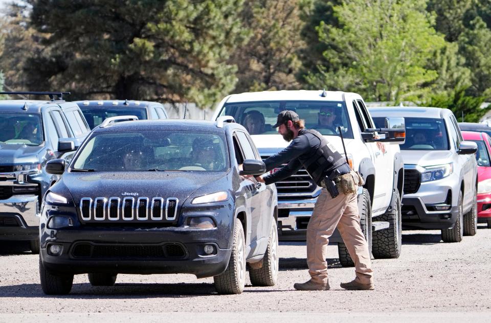
Evacuations ordered
Multiple areas north and northeast of Flagstaff were in “Go” status as of mid-day Tuesday, meaning residents should evacuate right away.
Areas in “Go” status included:
Areas of Schultz Pass Road and Arizona Snowbowl
Timberline, northwest of Campbell Ave and US 89
Crater Estates Area
O'Leary
Areas south of Campbell Ave including past North Linda Lane
As of Monday evening, 2,195 households were in “Go” status for the Pipeline Fire and 281 households for the Haywire Fire, per Axlund from the sheriff’s office. Some "Go" evacuations were lifted Tuesday morning.
Evacuations are managed by the Coconino County Sheriff’s Office and Emergency Management. The county is asking those who have evacuated to call a number (928-679-8525) to be added to an information list.
'Ready, Set, Go': Here's what to know when natural disasters loom in Arizona
Who is in 'Set' status
Areas in “Set” status as of mid-day Tuesday included:
Mt. Elden Lookout Road and Mt. Elden Estates
Doney Park South
Antelope Hills
Doney Park North (moved from "Go")
McCann Estates (Silver Saddle Drive) (moved from "Go")
Silver Saddle Trailer Park (moved from "Go")
Fernwood Estates (moved from "Go")
Hutchison Acres (moved from "Go")
Swede Acres (moved from "Go")
Johnson Ranch (moved from "Go")
As of Monday evening, 1,584 households were in “Set” status for the Pipeline Fire and 57 households for the Haywire Fire, Axlund said. Some areas that were "Go" status Monday moved to "Set" status Tuesday morning.
All other areas nearby are in “Ready” status, according to Coconino County Emergency Management.
“Ready” means residents should prepare to evacuate, watch the situation and pack important items. “Set” means people should prepare to evacuate when given notice. “Go” means leave immediately.
The Flagstaff mayor’s emergency declaration recommended that all residents in impacted areas prepare emergency kits with clothes, medicine and documents and prepare emergency plans.
Road, other closures
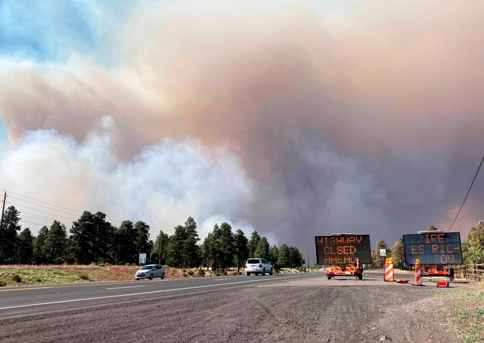
U.S. 89 was closed in both directions north of Flagstaff. The southbound side was closed at milepost 445 and the northbound side was closed at milepost 423. There is no estimated time for the road to reopen.
Buffalo Park, the Schultz Creek Natural Area, the Observatory Mesa Natural Area and certain Flagstaff Urban Trail System entrances were all closed until further notice as of Tuesday morning, the city announced. The Arizona Snowbowl was also closed.
Nearly the entire northern part of the Coconino National Forest was closed from Interstate 40 to the north.
Flagstaff’s Cinder Lake Landfill and hazardous products center were both closed, city officials announced Monday afternoon.
APS said it de-energized some power lines north of Flagstaff due to fire impacts.
Fire and smoke forecast
Critical fire conditions, including warm and windy weather, are exacerbating the fire. The wildfire was being pushed toward the east and Schultz Pass.
Winds Tuesday were expected to be weaker than Monday, but with gusts still expected to cause fire activity and increased smoke, according to the Arizona Department of Environmental Quality. Smoke is again expected to move to the east-northeast, and the Doney Park area may have moderate smoke impacts. The Navajo and Hope reservations may see light to moderate smoke impacts, per ADEQ.
Wind should lighten on Tuesday night, letting smoke drain into Fort Valley, Flagstaff and Doney Park and likely lift by Wednesday morning, according to ADEQ.
Wednesday's winds are forecast to be even lighter, with less daytime smoke impacts.
ADEQ officials say people in areas with heavy smoke impacts can close winds, turn off swamp coolers, use filtered HVAC systems and avoid being active outside.
Strong winds Monday contributed to difficult firefighting conditions and smoke movement with forecasted gusts up to 40-50 miles per hour, plus low humidity, according to the National Weather Service Flagstaff. Those conditions help wildfires spread rapidly.
Winds Tuesday were forecast to be lighter, from 11 to 16 miles per hour with gusts as high as 24 miles per hour.
Shelter and assistance info
The American Red Cross opened a shelter at Sinagua Middle School in Flagstaff for residents evacuated due to the Pipeline Fire.
The Navajo Nation was also offering emergency shelter at the Twin Arrows Navajo Casino Resort, with information available at 928-856-7200.
Northern Arizona University’s president asked students and NAU community members who need immediate help with housing, meals or emergency support due to the fires to email president@nau.edu.
There’s an animal shelter at Fort Tuthill, run by the Coconino Humane Association. High Country Humane has evacuated but is assisting with the stables at Fort Tuthill.
People evacuating can bring their household animals to Coconino Humane Association at 3501 E Butler Ave. and their livestock to self-service stables at Fort Tuthill County Stables.
St. Mary’s Food Bank planned to send a truckload of food and water to Flagstaff to help people impacted by the Pipeline Fire.
The fire call center number is 928-679-8525.
Reach the reporter at Alison.Steinbach@arizonarepublic.com or at 602-444-4282. Follow her on Twitter @alisteinbach.
Support local journalism. Subscribe to azcentral.com today.
This article originally appeared on Arizona Republic: Pipeline Fire burns near Flagstaff: Latest updates

