Pisgah National Forest fire still 0% contained; parts of WNC worsen due to 'extreme' drought
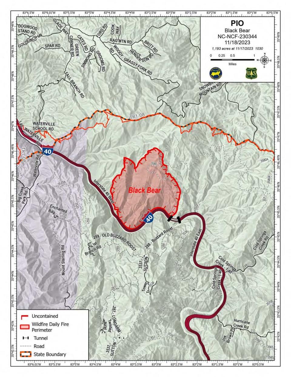
ASHEVILLE — A Haywood County Fire remains at 1,193 acres with no containment on Saturday after spreading more than 1,000 acres in a day, while drought conditions continue to worsen in Western North Carolina, according to the U.S. Forest Service.
However, spokesperson Meredith Hollowell said that acreage is based on an arial mapping flight, and the number could potentially increase Saturday “if an infrared flight occurs and collects updated fire data.”
“When a fire is very active from the beginning, the situation on the ground changes very rapidly and getting an accurate acreage measure can be challenging,” the U.S. Forest Service said in a Facebook post.
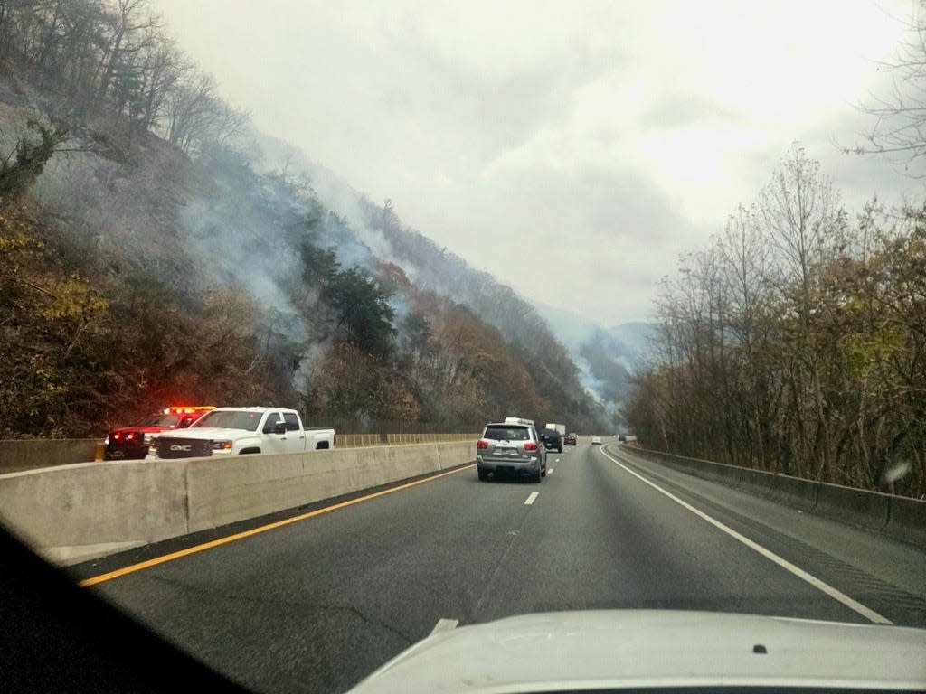
A traffic accident on I-40 near the border of North Carolina and Tennessee sparked the fire on Nov. 16, according to a U.S. Forest Service news release. Since then, the fire continues to burn on the Appalachian Ranger District of the Pisgah National Forest, which are federal lands managed by the USDA Forest Service.
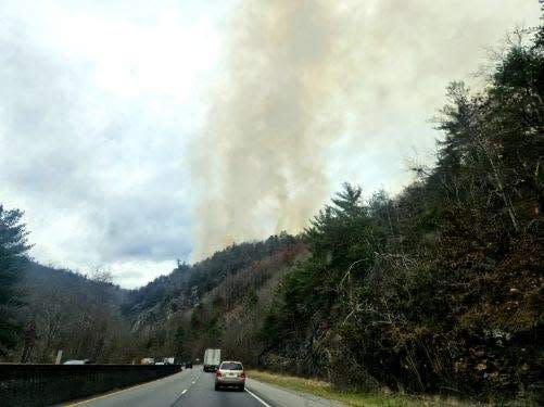
“The fire spread in vegetation north of the highway and rapidly progressed up steep slopes, partially driven by southeast winds,” the news release said. Hollowell added that “the fire started at the I-40 tunnel and has burned along a section of the highway, but has mostly not crossed over, except in the area of the tunnel.”
The interstate remains open, but reduced visibility along I-40 is possible due to fires in the area, according to the release. Hollowell said travel is expected to be impacted.
Firefighters identified primary containment lines using I-40 on the southwest of the fire, the Appalachian Trail from I-40 to Groundhog Creek Shelter on the north side, and Forest Road 3580 to the east of the fire, according to a release from N.C. Forest Service.
“Containment line work along the Appalachian Trail will consist of raking away forest floor litter and removing fallen trees, much like normal trail maintenance, to minimize impacts along the National Scenic Trail,” the release said.
Last update: Black Bear Fire in Haywood County up to 1,193 acres, 0% contained
Approximately 100 ground crew are working in four different divisions around the fire, with a total of 166 personnel assigned to the fire as of Saturday morning, according to Hollowell. The Southern Area Blue Incident Management Team has transitioned from the Collett Ridge Fire and will be managing the Black Bear Fire, according to a news release.
No structures have been lost or threatened, and there have been no reported injuries from the fire thus far. There are also no evacuations posted at this time, however Hollowell said that may change.
“That may change depending on the fire's behavior and we recommend residents in nearby communities make sure their local county emergency management offices have accurate contact information for residents,” Hollowell said.
The U.S. Forest Service asks hikers on the Appalachian Trail to stay connected to information through mobile apps that provide regular updates on the trial, “especially the local search and rescue notifications for the sections they're approaching.” To trail hikers, Hollowell says, “please take closure notices seriously.”
The Appalachian Trial is closed from I-40 to Max Patch. Road closures are also in effect for Cold Springs Road and Brown Gap Road, according to Hollowell.
Man charged with Poplar Drive Fire: Florida man charged with starting Edneyville wildfire, Forest Service reports
Drought worsens, with change in weather pattern coming
Since the beginning of November, 769 fires have burned on state and private lands statewide as of Friday, while dry conditions increase the risk of fire, according to the U.S. Forest Service.
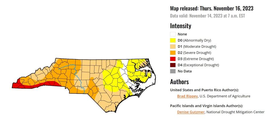
In an updated drought map released by the U.S. Drought Monitor Thursday, drought conditions in WNC have escalated from severe to extreme conditions in 10 southernmost counties, from Cleveland County west to Cherokee County. Severe drought conditions have also spread, with portions of 42 counties in North Carolina labeled as severe, including the southernmost portion of Buncombe County.
“The next couple days, we are expecting dry weather with high pressure building in today,” meteorologist Andrew Kimball with the National Weather Service told the Citizen Times Saturday. “By the end of today, wind should really die down. It looks like pretty much sunny skies and seasonable temperatures.”
National Park bans campfires: Great Smoky Mountains National Park bans all campfires; 700 fires in NC since Nov. 1
Kimball said they are expecting a pattern change early next week, with the area gradually increasing in moisture and humidity. A low-pressure system is expected to roll in through the Ohio Valley, bringing a plume of moisture from the Gulf of Mexico.
There is a 60-80% chance of rain on the night of Nov. 20, and a 90-100% chance of rain Nov. 21, according to Kimball.
“We’re pretty confident there will be rainfall, and that continues until Tuesday night,” Kimball added. “The southern part of the mountains, from Henderson County down to the border of South Carolina and Georgia, could get 1.5 to 2 inches of rain.”
Much of the rest of the mountains, especially north from Asheville and Waynesville, are forecasted to get an inch or less, Kimball said.
Protect your home from fire: Answer Man: Is Asheville at increased wildfire risk? How can we protect our homes?
Here are other updates on fires burning throughout WNC:
Poplar Drive Fire
The fire in Henderson County, which a Florida man has been charged with starting from a debris burn on Nov. 3, is nearly completely contained and has remained the same size, at 434 acres. On its 15th day ablaze, the Poplar Drive Fire is at 98% containment, according to the N.C. Forest Service.
“Firefighters continue to mop up and work on rehabilitation and repair efforts around the fire footprint,” the N.C. Forest Service said in a Nov. 18 news release.
One home, two cabins, one uninhabitable mobile home, one uninhabitable cabin and two outbuildings were destroyed, with another home suffering damage, the N.C. Forest Service said.
Collett Ridge Fire
The Collett Ridge Fire in the Cherokee and Macon county portions of the Nantahala National Forest is now 82% contained and remains at 5,505 acres, or 8.6 square miles, according to the U.S. Forest Service.
The fire, which a lightning strike first started Oct. 23 in the Cherokee County area of the Nantahala National Forest, is being managed “under unified command by the U.S. Forest Service and N.C. Forest Service,” the news release said.
The U.S. Forest Service said 223 personnel were assigned to the Collett Ridge fire, including one 20-person handcrew, one engine and one bulldozer, as well as two helicopters. As of the last update, the area from Big Stamp east to Shinbone Ridge and Signal Bald remains closed for the safety of the public and firefighters. The intersection of Little Fires Creek Road and Fires Creek Road is also closed. The Rim Trail is temporarily closed for approximately seven miles from Big Stamp to Shinbone.
Branch Fire
The Branch Fire in Wilkes County, which started Nov. 9, has reached 100% containment, according to the forest service. The fire’s footprint was 80 acres, and the cause remains under investigation. Though fully contained, the fire will still be patrolled and monitored by N.C. Forest Service personnel.
A burn ban was instated in 14 Western North Carolina counties Nov. 6 in response to severe drought conditions and multiple fires. On Nov. 8, the burn ban was expanded to an additional 16 counties amid persisting drought conditions and fires, with Gov. Roy Cooper declaring a state of emergency on Nov. 9.
The Blue Ridge Parkway has banned backcountry campfires, while the Great Smoky Mountains National Park has banned all campfires and charcoal use throughout the park. Backcountry campsites are closed in nine N.C. state parks. See a map of fires burning across Western North Carolina at https://data.citizen-times.com/fires.
Ryley Ober is the Public Safety Reporter for Asheville Citizen Times, part of the USA Today Network. Email her at rober@gannett.com and follow her on Twitter @ryleyober
This article originally appeared on Asheville Citizen Times: Black Bear Fire not contained Appalachian Trail closed drought worsens

