'Plant hardiness' can help map Wisconsin's changing climate. Here's how.
New data about where plants can grow best shows how Wisconsin has warmed over the past few decades.
In November, the U.S. Department of Agriculture released a new version of its Plant Hardiness Zone Map, which essentially provides a guide for gardeners and growers about which perennial plants will thrive in their area.
The previous version was released in 2012. Since then, about half the country shifted a half-zone warmer, the agency said in a news release. That includes Wisconsin, which all but lost a cold-hardy zone in the far northwest part of the state and added a new, warmer zone along the southern edge of Lake Michigan.
Although these changes won't affect the average gardener much, horticultural experts do say they indicate the warming trend wrought by climate change.
Here's what to know about the new map.
What is a plant hardiness zone?
The USDA's plant hardiness zone map shows the average lowest temperature that a region has experienced over the past 30 years.
The map splits the U.S. into several "zones," from places where the average minimum temperature reaches a bone-chilling -35 degrees Fahrenheit to places where it's a balmy 65.
Who uses this map, and how?
The map is meant for horticulture, not agriculture, said Chris Kucharik, a plant and agrosystem sciences professor at the University of Wisconsin-Madison, because farmers in the Midwest have largely been planting the same crops for decades.
Instead, the tool is useful for plant nurseries and landscape architects to educate people on the appropriate plants and trees to plant in their yards or gardens, Kucharik said. It can also be helpful for people who move to a different part of the country and need to know what to plant in their new home.
The USDA's Risk Management Agency does refer to hardiness zone designations when setting certain standards for crop insurance, according to the agency.
More: A wetter world is changing Midwest farming. Can growers adapt?
How did Wisconsin's zones change?
Since the last map was released in 2012, all of Wisconsin's hardiness zones have shifted about half a zone warmer, said Laura Jull, associate professor in the plant and agrosystem sciences department at UW-Madison.
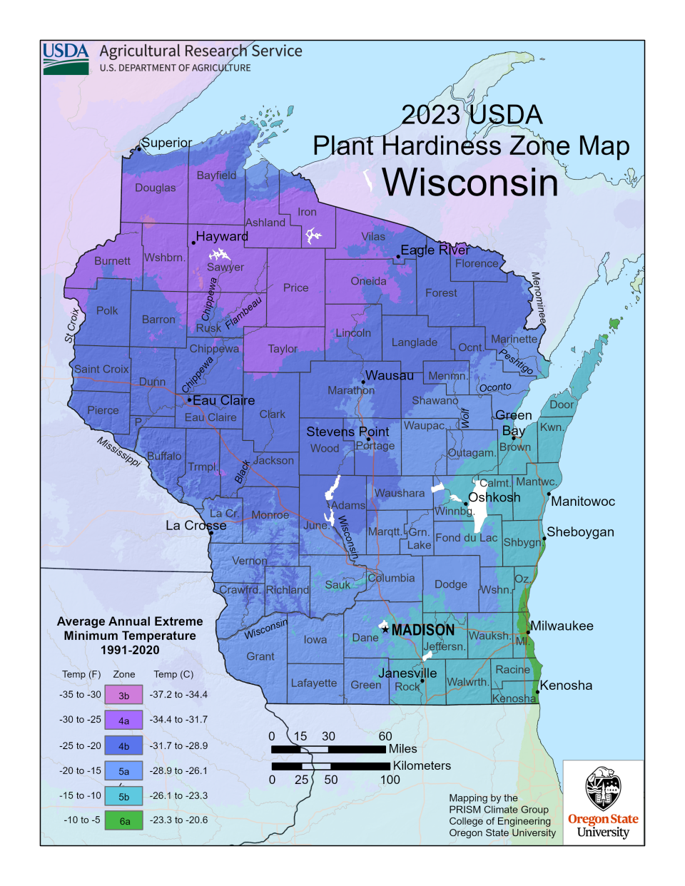
Zone 3, for which average minimum temperatures span -40 to -30 degrees Fahrenheit, has almost completely disappeared from Wisconsin, Jull said. And a sliver of the counties along Lake Michigan in the southern part of the state have shifted to Zone 6a, in which average minimum temperatures range from -5 to -10 degrees Fahrenheit.
More: How does Lake Michigan affect the weather in Milwaukee?
What can that tell us about Wisconsin's changing climate?
The USDA website cautions that "changes in zones are not reliable evidence of whether there has been global warming," because climate changes are typically based on trends in overall average temperatures over a longer period of time.
But Kucharik said he believes the zone changes do provide some evidence. Research shows that Wisconsin doesn't have as many very cold nights as it did in the past, and because of that, he said he isn't surprised to see the zones shift slightly warmer.
"I think it's completely connected to the way the climate has been changing over the past half-century or so," he said.
Jull said it's concerning that northern Wisconsin is getting warmer, particularly because it could eventually lead to the loss of native species that are pushing further north and west to find temperatures they can survive in. By 2050, she said, it's predicted that some species, like black spruce, may no longer be found in Wisconsin.
How accurate is the map?
Kucharik describes the map as good, but not perfect, for a few reasons.
First, the map's averaging of the lowest minimum temperatures means that it doesn't represent the full range of extremes that can happen during winter. For example, although Milwaukee now sits in the warmer Zone 6a, anyone who lived there during the polar vortex of early 2019 will remember that it got much colder than the zone's listed range — including a chilly -23 degrees at the end of the month, Kucharik pointed out.
Second, because not everyone has a weather station in their backyard, the map uses statistics to fill in gaps between stations. It's still a fairly accurate picture, Kucharik said, but this means the map doesn't account for microclimates — which happen when a certain area has different atmospheric conditions than surrounding areas, often because of topography like hills or valleys. Those can occur over the scale of a few hundred feet, he said.
Finally, this map had more observational data to draw from than the previous one, using more than 13,400 weather stations compared with about 8,000 in the 2012 version, according to the USDA. It's a good thing, Kucharik said, but it could mean that certain zone shifts are more a product of better data than a true change in weather conditions.
What do these changes mean for the average gardener?
Not much. The slight warming doesn't mean that all the plants that thrive in Zone 6a will suddenly thrive in Milwaukee, Jull cautioned.
"If you're trying new species that push the envelope in terms of hardiness, be aware that they may die," Jull said.
That's why she recommends buying plants from local nurseries, which will understand the unique conditions of the region people live in.
Ben French, vice president of propagation and product development at Johnson's Nursery, headquartered in Menomonee Falls, said tools like the hardiness zone map are just one factor to consider when buying plants. He said the nursery bases its recommendations off of real-life experience, which takes into account sun exposure and other things that can affect plant growth, rather than just average minimum temperatures.
"Sometimes we say, 'Yeah, it says Zone 5b, but it doesn't make it here unless you can provide it with a sheltered location,'" French said.
Will plants from further south ever migrate into Wisconsin?
If these trends continue, it's possible that decades down the line, plants that thrived a little further south would start surviving in Wisconsin, Kucharik said.
French said his nursery is paying attention to that phenomenon, but he's wary of dropping a plant in a new area without understanding the effects it might have on its surroundings.
The nursery has a keen interest in native plants, which are often more climate-resilient because they've existed in Wisconsin for hundreds, if not thousands, of years.
More: Want your yard to withstand extreme weather in Wisconsin? Plant native plants
How can I see which hardiness zone I'm in?
You can enter your zip code on the USDA's Plant Hardiness Zone Map website to figure out the hardiness zone for your region. The site offers other tips for growers, too, including more detailed instructions about how to use the map.
Madeline Heim is a Report for America corps reporter who writes about environmental issues in the Mississippi River watershed and across Wisconsin. Contact her at 920-996-7266 or mheim@gannett.com.
Please consider supporting journalism that informs our democracy with a tax-deductible gift to this reporting effort at jsonline.com/RFA or by check made out to The GroundTruth Project with subject line Report for America Milwaukee Journal Sentinel Campaign. Address: The GroundTruth Project, Lockbox Services, 9450 SW Gemini Dr, PMB 46837, Beaverton, Oregon 97008-7105.
This article originally appeared on Milwaukee Journal Sentinel: What is a plant hardiness zone and what does it mean for Wisconsin?

