Arctic air looms over B.C. as temperatures plummet, warnings issued
The first full week of 2024 started off on a blustery note for British Columbia as a powerful wind storm blew into the province on earlier this week.
DON'T MISS: If it's too cold for you to be outside, it's too cold for your pets
So, after this late taste of winter, many may be wondering what's next if anything at all. Unfortunately, this wind storm was only the start of B.C.'s wintry woes.
A polar vortex is on the move across Western Canada, and it will have a direct effect on B.C. and the South Coast’s weather in the next few days.
Plunging temperatures
Below freezing daytime highs are forecast Friday across all of B.C., prompting Environment and Climate Change Canada (ECCC) to issue extreme cold and Arctic outflow warnings across the majority of the province. Temperatures will be significantly colder overnight as well as throughout the Interior.

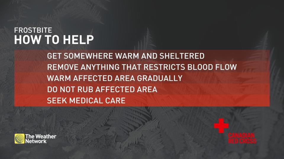
"Frostbite and hypothermia can occur within minutes if adequate precautions are not taken when outdoors. Any skin exposure will result in frostbite," ECCC stated in one of its warnings. "Watch for cold related symptoms: shortness of breath, chest pain, muscle pain and weakness, numbness and colour change in fingers and toes."
To the north, Prince George could see temperatures dip into the -30's on Friday, with temperatures only getting colder towards the Prairies.
Frigid wind chills will also add an extra bite to the air, so be sure to bundle up when heading outside.
SEE ALSO: What is wind chill and why does it 'feel' so miserable?
The extreme cold has even prompted several ski resorts to close their doors for the weekend, with the risk of frostbite and hypothermia to people on the slopes being too great.
The cold in combination with fallen snow has also led to some roadways freezing over, so be extremely cautious when driving and consider staying home if possible. Reports of major accidents and other impacts have already been reported on Thursday night as the cold air and snow moved in.
Back in the City of #Vancouver & side streets are skating rinks!Snow that fell earlier, melting slightly, now freezing w/ temps at -8°C/17°F. If you live on a side street & don't have proper tires, don't try driving.. you won't get up a hill.#BCwx #BCcold #BCstorm #YVRwx... pic.twitter.com/FxS65qJmDi
Back in the City of Ryan Voutilainen 🇨🇦🇫🇮 on Twitter: "Back in the City of #Vancouver & side streets are skating rinks!Snow that fell earlier, melting slightly, now freezing w/ temps at -8°C/17°F. If you live on a side street & don't have proper tires, don't try driving.. you won't get up a hill.#BCwx #BCcold #BCstorm #YVRwx... pic.twitter.com/FxS65qJmDi / Twitter" & side streets are skating rinks!
Snow that fell earlier, melting slightly, now freezing w/ temps at -8°C/17°F.
If you live on a side street & don’t have proper tires, don’t try driving.. you won’t get up a hill.Ryan Voutilainen 🇨🇦🇫🇮 on Twitter: "Back in the City of #Vancouver & side streets are skating rinks!Snow that fell earlier, melting slightly, now freezing w/ temps at -8°C/17°F. If you live on a side street & don't have proper tires, don't try driving.. you won't get up a hill.#BCwx #BCcold #BCstorm #YVRwx... pic.twitter.com/FxS65qJmDi / Twitter" Ryan Voutilainen 🇨🇦🇫🇮 on Twitter: "Back in the City of #Vancouver & side streets are skating rinks!Snow that fell earlier, melting slightly, now freezing w/ temps at -8°C/17°F. If you live on a side street & don't have proper tires, don't try driving.. you won't get up a hill.#BCwx #BCcold #BCstorm #YVRwx... pic.twitter.com/FxS65qJmDi / Twitter" Ryan Voutilainen 🇨🇦🇫🇮 on Twitter: "Back in the City of #Vancouver & side streets are skating rinks!Snow that fell earlier, melting slightly, now freezing w/ temps at -8°C/17°F. If you live on a side street & don't have proper tires, don't try driving.. you won't get up a hill.#BCwx #BCcold #BCstorm #YVRwx... pic.twitter.com/FxS65qJmDi / Twitter" Ryan Voutilainen 🇨🇦🇫🇮 on Twitter: "Back in the City of #Vancouver & side streets are skating rinks!Snow that fell earlier, melting slightly, now freezing w/ temps at -8°C/17°F. If you live on a side street & don't have proper tires, don't try driving.. you won't get up a hill.#BCwx #BCcold #BCstorm #YVRwx... pic.twitter.com/FxS65qJmDi / Twitter"… Ryan Voutilainen 🇨🇦🇫🇮 on Twitter: "Back in the City of #Vancouver & side streets are skating rinks!Snow that fell earlier, melting slightly, now freezing w/ temps at -8°C/17°F. If you live on a side street & don't have proper tires, don't try driving.. you won't get up a hill.#BCwx #BCcold #BCstorm #YVRwx... pic.twitter.com/FxS65qJmDi / Twitter"— Ryan Voutilainen 🇨🇦🇫🇮 (@RyanVoutilainen) Ryan Voutilainen 🇨🇦🇫🇮 on Twitter: "Back in the City of #Vancouver & side streets are skating rinks!Snow that fell earlier, melting slightly, now freezing w/ temps at -8°C/17°F. If you live on a side street & don't have proper tires, don't try driving.. you won't get up a hill.#BCwx #BCcold #BCstorm #YVRwx... pic.twitter.com/FxS65qJmDi / Twitter"
A 16 car pile up on Nelson Street has it closed between Marine Drive and Rumble Street in Burnaby. Be careful out there! 🥶 #bcstorm #bcsnow #burnaby cc @AM730Traffic @CityNewsTraffic @DailHiveVan @GlobalBC @CTVVancouver @CBCVancouver @BurnabyRCMP @CityofBurnaby @50ShadesofVan pic.twitter.com/nR0q4j3Spg
A 16 car pile up on Nelson Street has it closed between Marine Drive and Rumble Street in Burnaby. Be careful out there! 🥶 Philipp Postrehovsky on Twitter: "A 16 car pile up on Nelson Street has it closed between Marine Drive and Rumble Street in Burnaby. Be careful out there! 🥶 #bcstorm #bcsnow #burnaby cc @AM730Traffic @CityNewsTraffic @DailHiveVan @GlobalBC @CTVVancouver @CBCVancouver @BurnabyRCMP @CityofBurnaby @50ShadesofVan pic.twitter.com/nR0q4j3Spg / Twitter" Philipp Postrehovsky on Twitter: "A 16 car pile up on Nelson Street has it closed between Marine Drive and Rumble Street in Burnaby. Be careful out there! 🥶 #bcstorm #bcsnow #burnaby cc @AM730Traffic @CityNewsTraffic @DailHiveVan @GlobalBC @CTVVancouver @CBCVancouver @BurnabyRCMP @CityofBurnaby @50ShadesofVan pic.twitter.com/nR0q4j3Spg / Twitter" Philipp Postrehovsky on Twitter: "A 16 car pile up on Nelson Street has it closed between Marine Drive and Rumble Street in Burnaby. Be careful out there! 🥶 #bcstorm #bcsnow #burnaby cc @AM730Traffic @CityNewsTraffic @DailHiveVan @GlobalBC @CTVVancouver @CBCVancouver @BurnabyRCMP @CityofBurnaby @50ShadesofVan pic.twitter.com/nR0q4j3Spg / Twitter" cc Philipp Postrehovsky on Twitter: "A 16 car pile up on Nelson Street has it closed between Marine Drive and Rumble Street in Burnaby. Be careful out there! 🥶 #bcstorm #bcsnow #burnaby cc @AM730Traffic @CityNewsTraffic @DailHiveVan @GlobalBC @CTVVancouver @CBCVancouver @BurnabyRCMP @CityofBurnaby @50ShadesofVan pic.twitter.com/nR0q4j3Spg / Twitter" Philipp Postrehovsky on Twitter: "A 16 car pile up on Nelson Street has it closed between Marine Drive and Rumble Street in Burnaby. Be careful out there! 🥶 #bcstorm #bcsnow #burnaby cc @AM730Traffic @CityNewsTraffic @DailHiveVan @GlobalBC @CTVVancouver @CBCVancouver @BurnabyRCMP @CityofBurnaby @50ShadesofVan pic.twitter.com/nR0q4j3Spg / Twitter" @DailHiveVan Philipp Postrehovsky on Twitter: "A 16 car pile up on Nelson Street has it closed between Marine Drive and Rumble Street in Burnaby. Be careful out there! 🥶 #bcstorm #bcsnow #burnaby cc @AM730Traffic @CityNewsTraffic @DailHiveVan @GlobalBC @CTVVancouver @CBCVancouver @BurnabyRCMP @CityofBurnaby @50ShadesofVan pic.twitter.com/nR0q4j3Spg / Twitter" Philipp Postrehovsky on Twitter: "A 16 car pile up on Nelson Street has it closed between Marine Drive and Rumble Street in Burnaby. Be careful out there! 🥶 #bcstorm #bcsnow #burnaby cc @AM730Traffic @CityNewsTraffic @DailHiveVan @GlobalBC @CTVVancouver @CBCVancouver @BurnabyRCMP @CityofBurnaby @50ShadesofVan pic.twitter.com/nR0q4j3Spg / Twitter" Philipp Postrehovsky on Twitter: "A 16 car pile up on Nelson Street has it closed between Marine Drive and Rumble Street in Burnaby. Be careful out there! 🥶 #bcstorm #bcsnow #burnaby cc @AM730Traffic @CityNewsTraffic @DailHiveVan @GlobalBC @CTVVancouver @CBCVancouver @BurnabyRCMP @CityofBurnaby @50ShadesofVan pic.twitter.com/nR0q4j3Spg / Twitter" Philipp Postrehovsky on Twitter: "A 16 car pile up on Nelson Street has it closed between Marine Drive and Rumble Street in Burnaby. Be careful out there! 🥶 #bcstorm #bcsnow #burnaby cc @AM730Traffic @CityNewsTraffic @DailHiveVan @GlobalBC @CTVVancouver @CBCVancouver @BurnabyRCMP @CityofBurnaby @50ShadesofVan pic.twitter.com/nR0q4j3Spg / Twitter" Philipp Postrehovsky on Twitter: "A 16 car pile up on Nelson Street has it closed between Marine Drive and Rumble Street in Burnaby. Be careful out there! 🥶 #bcstorm #bcsnow #burnaby cc @AM730Traffic @CityNewsTraffic @DailHiveVan @GlobalBC @CTVVancouver @CBCVancouver @BurnabyRCMP @CityofBurnaby @50ShadesofVan pic.twitter.com/nR0q4j3Spg / Twitter" Philipp Postrehovsky on Twitter: "A 16 car pile up on Nelson Street has it closed between Marine Drive and Rumble Street in Burnaby. Be careful out there! 🥶 #bcstorm #bcsnow #burnaby cc @AM730Traffic @CityNewsTraffic @DailHiveVan @GlobalBC @CTVVancouver @CBCVancouver @BurnabyRCMP @CityofBurnaby @50ShadesofVan pic.twitter.com/nR0q4j3Spg / Twitter" Philipp Postrehovsky on Twitter: "A 16 car pile up on Nelson Street has it closed between Marine Drive and Rumble Street in Burnaby. Be careful out there! 🥶 #bcstorm #bcsnow #burnaby cc @AM730Traffic @CityNewsTraffic @DailHiveVan @GlobalBC @CTVVancouver @CBCVancouver @BurnabyRCMP @CityofBurnaby @50ShadesofVan pic.twitter.com/nR0q4j3Spg / Twitter"
WATCH: Vancouver Island, tracking snowfall and arctic air across the area
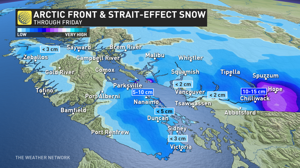
A side of straight-effect snow
Wind blowing off the continent will interact with the warmer straits, fuelling what's known as strait-effect snow -- characterized by narrow bands of heavy snowfall.
The snow may impact the Malahat to Victoria Thursday night and into Friday, with localized amounts of 5-10 cm between Nanaimo and Parksville. Chilliwack towards Hope could see totals closer 10-15 cm.
However, snowfall amounts drastically vary and depend highly on wind direction, which may shift leading up to the event.
Stay with The Weather Network for more forecast information and updates across for your weather across B.C.

