A polar vortex could still impact this year's winter weather, just not this weekend
The term "polar vortex" has been a "rising star" in recent years, according to the National Oceanic and Atmospheric Administration's polar vortex blog.
It's such a star, in fact, that a viral image making the rounds on social media lately might have sparked concerns and some confusion about whether the winter storm in this weekend's forecast could be part of a polar vortex.
Good news: It's not.
According to the blog, its purpose is "monitoring and forecasting the stratospheric polar vortexes and how they do and don't – mostly don't! – affect extreme winter weather and seasonal climate."
Here's what you need to know about polar vortexes, including if one is coming to the U.S. soon, and a weather forecast for this upcoming weekend.
Weekend weather forecast: Big snow storm in Northeast to start 2024? Forecast says snow could finally be on the way.
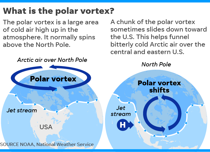
What is a polar vortex?
According to the NOAA's polar vortex blog, the term is not synonymous with "cold snap."
Rather, a polar vortex is a "well-known feature of Earth's atmosphere that describes the high-altitude winds that blow around the pole every winter, miles above us in a region called the stratosphere."
The blog says the stratospheric polar vortex forms in the winter hemisphere when the Earth's pole is pointed away from the sun.
"The polar stratosphere enters darkness and becomes cold relative to the tropical stratosphere," the blog says. The temperature contrast makes for strong winds in the stratosphere that blow from west to east.
The wintertime stratospheric wind is what we call the Arctic polar vortex.
Weekend weather forecast
After a wait of nearly two years, a major snowstorm could hit big cities including New York City and Washington D.C. this weekend — though the forecast was far from certain as of Wednesday.
According to AccuWeather, for many locations near the Interstate 95 corridor, it has been two winters since there was an inch of snow. This storm could change that.
But Weather.com meteorologist Chris Dolce said that "uncertainty remains high at this early stage given questions about the storm's track and how much cold air will be available near the coast."
This many days away, with the ingredients of the storm not even over the U.S. yet, the computer models meteorologists use show that a potent storm is likely, but the details of timing, track and amount of snow remained fuzzy.
"Snowfall forecasting is among the most challenging tasks meteorologists face," Dolce said. "That's because of several factors that can be uncertain days ahead of a potential storm's arrival."
Those factors include the amount of cold air available for snow to develop, which if absent can mean it rains instead.
2024 winter weather outlook
Some experts told USA TODAY we might not see much snow because we're in El Niño, a warm phase, with heavier cold and snow periods not occurring until January.
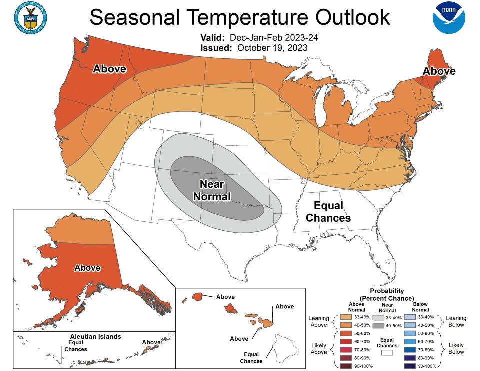
According to NOAA's seasonal temperature outlook, the northernmost states will see above-average temperatures in February, March and April, especially in New England and the Pacific Northwest. Most of Texas will see below-average temperatures.
Warm-weather predictions are in part due to El Niño.
Contributing: Doyle Rice, USA TODAY
This article originally appeared on USA TODAY: Will a polar vortex hit the US? Interest spikes ahead of winter storm

