Popular Horsetooth Mountain Open Space opens new trail connection
As if Horsetooth Mountain Open Space isn't popular enough, a new trail connection recently opened to make it even more accessible.
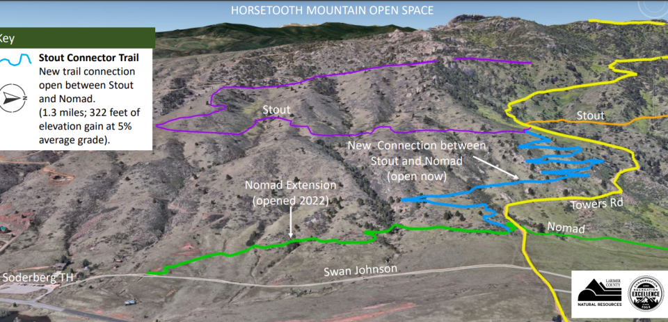
Here's what you need to know about the new Stout Connector Trail:
Why was the new trail connector built?
The Stout Connector Trail intends to make it easier for those accessing the open space's more than 30 miles of trails from the Soderberg Trailhead, located off Shoreline Drive on the west side of Horsetooth Reservoir.
Before the connection was built, hikers and cyclists had to grind up the steep lower sections of Towers Road, a service road that can approach a 20% incline. The trail also is open to horseback riding.
The new trail offers an alternative to that steep section of Towers and connects the Stout and Nomad trails. The trail averages a 5% grade thanks to nine switchbacks resulting in 322 feet of elevation gain over the 1.3 miles. This connector is rated as a moderate hike.
The new trail will help maintain long-term sustainability and reduce habitat fragmentation, according to a Larimer County Department of Natural Resources news release.
In 2022, an extension of the Nomad trail connected the existing Nomad Trail to the Soderberg Trailhead and now it connects to the new Nomad Connector Trail.
Can you get to the top of Horstooth Rock from the new trail connection?
Yes.
You can either hop on the less steep but long hike up Towers Road to the top, which is 3.8 miles from the Soderberg Trailhead, or you can get on the Stout Trail, visit Horsetooth Falls, and then hike up various trail options to the top of the rock.
A more direct route to the top of Horsetooth Rock is from the main Horsetooth Mountain parking lot, located off Larimer County Road 38E. If that parking lot is full, which it often is on summer weekends, you will need to see if parking is available at the Soderberg parking lot.
The open space has a main parking lot webcam that can be found at larimer.gov/naturalresources/parks/webcams.
This new trail will be popular, so do this before you head out
Larimer County has about 1,400 miles of trail, but you can expect this new trail to be especially crowded.
With that in mind, make sure to follow trail etiquette of bikers yielding to other users, downhill bikers stopping for everyone and hikers yielding to equestrians.
Visitors should check the CoTREX app, trails.colorado.gov, for current advisories or closures before heading out.For more information, visit larimer.gov/naturalresources.
Fourteener warning: Deep snow makes Rocky Mountain National Park's Longs Peak too dangerous to climb
This article originally appeared on Fort Collins Coloradoan: Check out Horsetooth Mountain Open Space's new trail connection

