Idalia strengthened to a Category 1 hurricane on Tuesday
Article first published: Tuesday, Aug. 29, 2023, 5 a.m. ET
Article last updated: Tuesday, Aug. 29, 2023, 8 a.m. ET
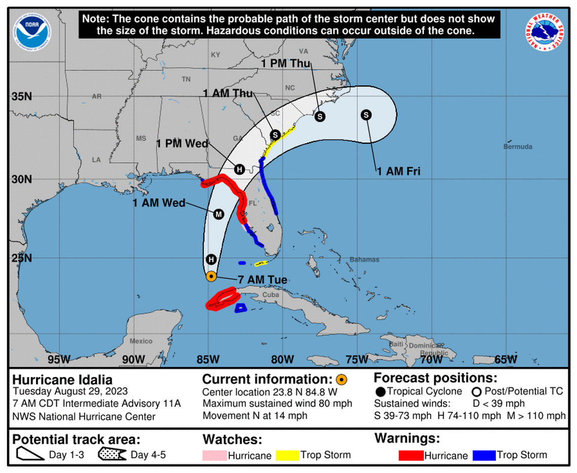
According to the National Hurricane Center’s 8 am Tuesday advisory, Idalia has become a Category 1 hurricane with sustained winds of 75 mph after intensifying from a tropical storm.
Category 1 Hurricane Idalia is 135 miles west-southwest of the Dry Tortugas and 320 miles south-southwest of Tampa Florida, with maximum sustained wind of 80 mph. It’s moving 14 mph to the north.
"... the center of Idalia is forecast to move over the eastern Gulf of Mexico today, reach the Gulf coast of Florida within the Hurricane Warning area on Wednesday, and move close to the Carolina coastline on Thursday." meteorologists observed. "Rapid intensification is likely through landfall, and Idalia is forecast to become an extremely dangerous major hurricane before landfall on Wednesday."
YESTERDAY (Monday):
Yesterday, Idalia moved away from Cuba and advanced into the Gulf of Mexico
A storm surge warning and a hurricane warning have been issued by forecasters for portions of the west coast of Florida.
SUMMARY OF WATCHES AND WARNINGS IN EFFECT:
A Storm Surge Warning is in effect for:
- Englewood northward to Indian Pass, including Tampa Bay
A Hurricane Warning is in effect for:
- Cuban province of Pinar del Rio
- Middle of Longboat Key northward to Indian Pass, including Tampa Bay
A Tropical Storm Warning is in effect for:
- Isle of Youth Cuba
- Dry Tortugas Florida
- Chokoloskee northward to the Middle of Longboat Key
- West of Indian Pass to Mexico Beach
- Sebastian Inlet, Florida to Altamaha Sound, Georgia
A Storm Surge Watch is in effect for:
- Chokoloskee northward to Englewood, including Charlotte Harbour
- Mouth of the St. Mary's River to South Santee River South Carolina
A Hurricane Watch is in effect for:
- Englewood to the Middle of Longboat Key
A Tropical Storm Watch is in effect for:
- Lower Florida Keys west of the west end of the Seven Mile Bridge
- Altamaha Sound northward to South Santee River South Carolina
A Hurricane Warning means that hurricane conditions are expected somewhere within the warning area. Preparations to protect life and property should be rushed to completion.
A Storm Surge Warning means there is a danger of life-threatening inundation, from rising water moving inland from the coastline, during the next 36 hours in the indicated locations. For a depiction of areas at risk, please see the National Weather Service Storm Surge Watch/Warning Graphic, available at hurricanes.gov. This is a life-threatening situation. Persons located within these areas should take all necessary actions to protect life and property from rising water and the potential for other dangerous conditions. Promptly follow evacuation and other instructions from local officials.
A Tropical Storm Warning means that tropical storm conditions are expected somewhere within the warning area.
A Storm Surge Watch means there is a possibility of life- threatening inundation, from rising water moving inland from the coastline, in the indicated locations during the next 48 hours. For a depiction of areas at risk, please see the National Weather Service Storm Surge Watch/Warning Graphic, available at hurricanes.gov.
A Hurricane Watch means that hurricane conditions are possible within the watch area.
A Tropical Storm Watch means that tropical storm conditions are possible within the watch area, generally within 48 hours.
Interests elsewhere along the southeastern U.S. coast should monitor the progress of this system. Additional watches and warnings along the southeast United States coast will likely be required later today.
HAZARDS AFFECTING LAND:
STORM SURGE: The combination of a dangerous storm surge and the tide will cause normally dry areas near the coast to be flooded by rising waters moving inland from the shoreline. The water could reach the following heights above ground somewhere in the indicated areas if the peak surge occurs at the time of high tide...
Aucilla River, FL to Chassahowitzka, FL...8-12 ft Chassahowitzka, FL to Anclote River, FL...6-9 ft Ochlockonee River, FL to Aucilla River, FL...5-8 ft Anclote River, FL to Middle of Longboat Key, FL...4-7 ft Tampa Bay...4-7 ft Middle of Longboat Key, FL to Englewood, FL...3-5 ft Englewood, FL to Chokoloskee, FL...2-4 ft Charlotte Harbor...2-4 ft Indian Pass, FL to Ochlockonee River, FL...3-5 ft Mouth of the St. Mary's River to South Santee, SC...2-4 ft Chokoloskee, FL to East Cape Sable, FL...1-3 ft Flagler/Volusia County Line, FL to Mouth of St. Mary's River...1-3 ft Indian Pass to Mexico Beach...1 to 3 ft. Florida Keys...1-2 ft
The deepest water will occur along the immediate coast in areas of onshore winds, where the surge will be accompanied by large and dangerous waves. Surge-related flooding depends on the relative timing of the surge and the tidal cycle, and can vary greatly over short distances.
Elevated water levels along the southern coast of Pinar del Rio, Cuba will gradually subside today.
WIND: Hurricane and tropical storm conditions are expected within the warning areas in western Cuba through this morning.
Hurricane conditions are expected within the hurricane warning area in Florida by late today or Wednesday, with tropical storm conditions beginning today.
Tropical storm conditions are expected in the Dry Tortugas soon and within the tropical storm warning area along the Florida Gulf coast and the Florida west coast later today.
Tropical storm conditions are expected to begin on Wednesday in the warning area along the east coast of Florida and South Carolina Tropical storm conditions are possible along the southeast U.S. coast within the southern portions of the watch area by early Wednesday.
RAINFALL: Idalia is expected to produce the following rainfall amounts:
Western Cuba: 4 to 7 inches, with isolated higher totals of 10 inches.
Portions of the west coast of Florida, the Florida Panhandle, southeast Georgia and the eastern Carolinas: 4 to 8 inches from today into Thursday. Isolated higher totals of 12 inches possible, primarily near landfall in northern Florida.
This rainfall may lead to flash and urban flooding, and landslides across western Cuba.
Areas of flash and urban flooding, some of which may be locally significant, are expected across portions of the west coast of Florida, the Florida Panhandle, and southern Georgia today into Wednesday, spreading into portions of the eastern Carolinas Wednesday into Thursday.
SURF: Swells generated by Idalia are affecting portions of the southern coast of Cuba and eastern Yucatan. These swells will spread northward along the eastern United States Gulf Coast during the next day or two. These swells are likely to cause life- threatening surf and rip current conditions.
TORNADOES: A few tornadoes will be possible later day along the west central Florida coast. The tornado threat will spread northward into the Florida Big Bend by tonight.
Source: National Hurricane Center
This article was generated by the Miami Herald Bot, artificial intelligence software that analyzes information from the National Hurricane Center and applies it to templates created by journalists in the newsroom. We are experimenting with this and other new ways of providing more useful content to our readers and subscribers. You can report errors or bugs to mcclatchybot@mcclatchy.com. Full hurricane coverage at miamiherald.com/news/weather/hurricane/

