Potential for severe storms loom over parts of Ontario, Quebec this week
Following an active weather weekend in parts of Ontario and Quebec, there is a new risk for more severe storms to roll through these regions on Monday and Tuesday.
Northern Ontario has been thrown into the mix as a low-pressure system makes its way throughout the region, providing a good environment for severe thunderstorms to potentially develop.
This bout of possible severe weather comes after tornado watches and warnings were issued in eastern Ontario and central Quebec on Saturday, which postponed Canada Day celebrations in Ottawa and caused a landslide in Rivière-Éternité, Que., which has displaced hundreds of residents.
Ontario and Quebec will also see hot and humid temperatures throughout this week, which could also increase the risk of thunderstorm activity.
JULY OUTLOOK: A turbulent July promises smoke, storms, heat, and drought across Canada
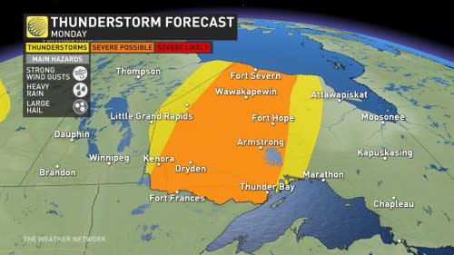
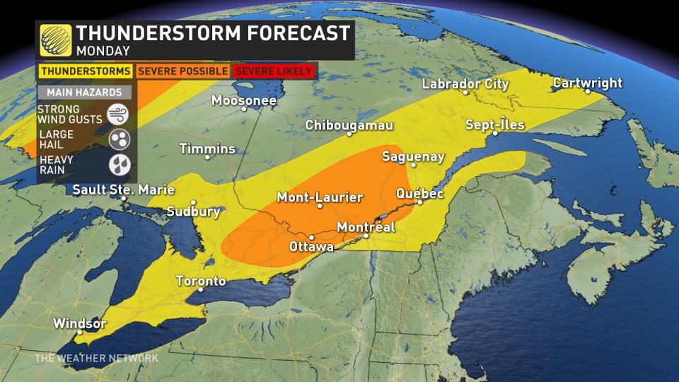
Monday
Areas: Northern Ontario, eastern Ontario and southern Quebec
Timing: Afternoon and the evening
Weather: A slow moving cold front making its way into northwestern Ontario will push hot, humid temperatures eastward as cooler, more seasonal air flows into the region behind the front. This provides the risk of severe thunderstorms developing in the afternoon along the boundary line, impacting cities like Thunder Bay, Fort Hope, and Armstrong.
The severe storm risk could potentially provide large hail, heavy rainfall and strong wind gusts.
The risk of severe weather decreases as the temperatures fall in the late evening.
Eastern Ontario and southern Quebec will also the potential of severe thunderstorms to develop throughout the afternoon as a low system makes it way through the area. These regions could also see potentially damaging high winds, heavy rainfall and large hail.
Southern Ontario will also see some wet weather on Monday, with the chance of some embedded thunderstorms around the Greater Horseshoe region.
Areas in northeastern Ontario will see temperatures in the 30s today, with humidex values making it feel closer to the mid-30s. Southern Ontario will be closer to seasonal today, but humidex values will make it feel closer to the low 30s as the muggy conditions continue.
RELATED: A hot, muggy week in Ontario and Quebec could break records
Tuesday
Areas: Northern Ontario, eastern Ontario and southern Quebec
Timing: Afternoon and the evening
Weather: Northern Ontario will see another round of potentially severe thunderstorms as a second low-pressure system moves into the area on Tuesday afternoon.
This low is pushing south toward the U.S., and as the warm front lifts in, areas around Thunder Bay towards Peawanuk could see storms move into the region. Strong wind gusts, heavy rainfall, and large hail are possible.
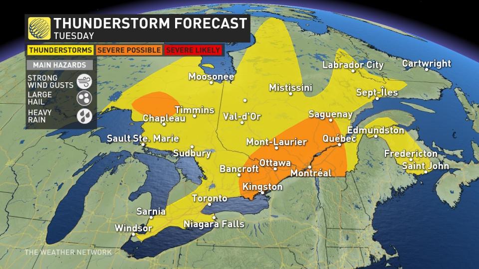
In eastern Ontario and Quebec, areas from Kingston up to Saguenay will again see the potential for severe thunderstorms. These areas can expect to see heavy rainfall throughout the afternoon.
In southeastern Ontario and along the Golden Horseshoe, scattered showers and embedded thunderstorms are more likely.
Temperatures in Ontario and Quebec will continue to reach upwards of 30°C as the mugginess sticks around for most of the week.
Stay tuned to The Weather Network for more forecast updates for Ontario and Quebec.

