Potential tropical depression moving toward eastern Caribbean. What the forecast says
The disturbance in the eastern Tropical Atlantic could strengthen into a tropical depression or storm named Emily over the next few days as it moves west over warmer waters and in the general direction of eastern Caribbean islands, according to the National Hurricane Center’s 8 p.m. Friday advisory.
Tropical Storm Don, in the open waters and not a threat to land, held its 50-mph winds and is forecast to weaken over the weekend.
Here’s the National Hurricane Center’s 11 a.m. Friday advisory on Don and 8 p.m. advisory on the disturbance.
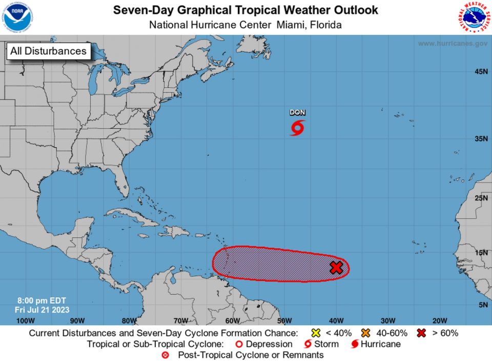
Where is the disturbance?
The tropical wave, designated Invest 95L, was roughly midway between the Cabo Verde Islands and the Lesser Antilles and was producing disorganized showers and thunderstorms.
That’s what’s happening to this wave, hurricane specialists said in Friday night’s advisory.
According to Brian McNoldy, senior research associate of the University of Miami’s Rosenstiel School, “The ocean is VERY warm ahead of it and those ocean temperatures are certainly relevant,” he wrote on his morning Tropical Atlantic Update blog. “Model guidance generally indicates it will reach the Lesser Antilles around Tuesday at tropical storm intensity or possibly Category 1 hurricane.”
Invest #95L is an easterly wave that exited the African coast on Monday and is centered ~1300 mi east of the Lesser Antilles. NHC is giving it a 40% probability of development within a week as it heads west across the deep tropics. Also, an update on #Don:https://t.co/oMEBIBHmpp
— Brian McNoldy (@BMcNoldy) July 21, 2023
The wave’s direction?
“Although environmental conditions are only marginally conducive, slow development is expected and this system will likely become a tropical depression early next week while it moves westward across the tropical Atlantic,” hurricane specialists John Cangialosi and Dave Roberts said in the 8 p.m. advisory.
If the disturbance manages to gain traction as it breaks free from the Convergence Zone and isn’t hampered by Saharan dust, “Those living in or traveling to the Lesser Antilles should prepare for a tropical depression or tropical storm (Emily would be the next name) approaching the area for next Monday into Tuesday,” said WPLG hurricane specialist Michael Lowry on his Eye on the Tropics blog Friday.
▪ Formation chance through 48 hours is at 50%.
▪ Formation chance through seven days is at 70%.
2PM EDT 21 July: An area of low pressure over the central tropical Atlantic has a medium chance of development through early next week as it moves westward over the tropical Atlantic. Get the latest information at https://t.co/Iqeygf1jum. #AL95 pic.twitter.com/OIZn2EWlG7
— National Hurricane Center (@NHC_Atlantic) July 21, 2023
Will the wave affect Florida?
The disturbance is not a threat to Florida currently.
Where is Tropical Storm Don?
Tropical Storm Don was about 1,085 miles west of the Azores, the Portuguese islands in the middle of the north Atlantic Ocean Friday morning.
Where is Don going?
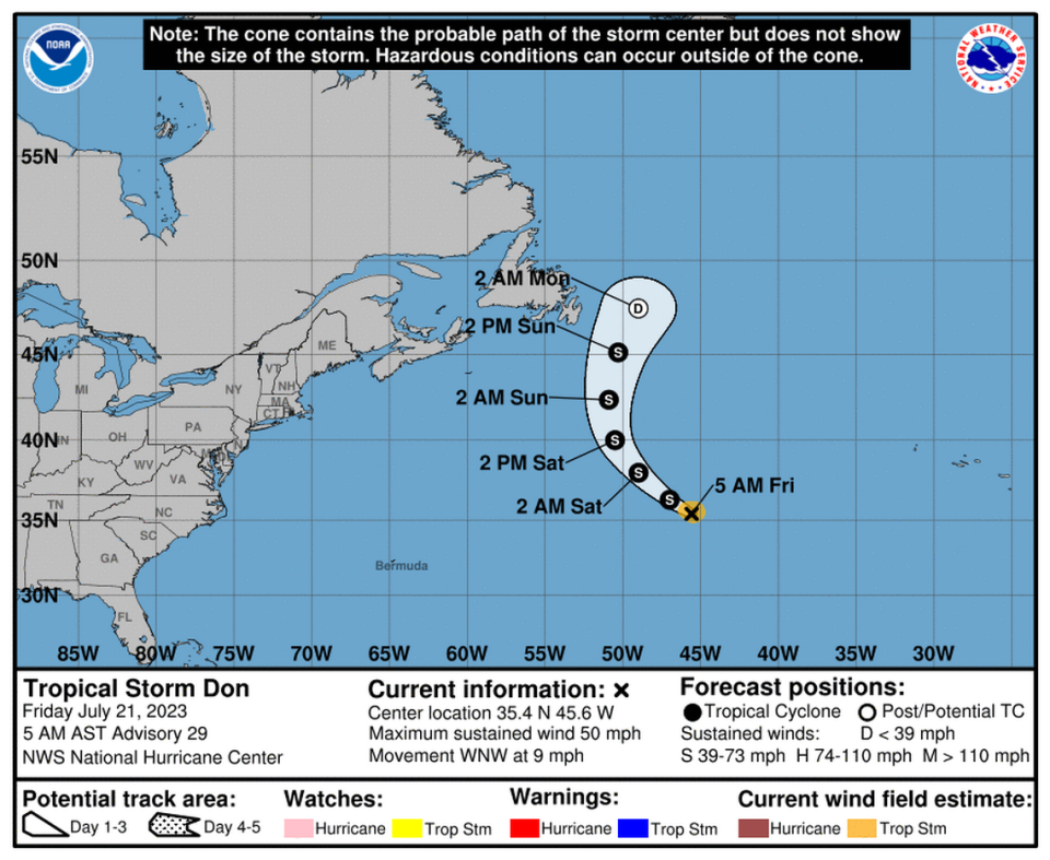
Don was moving west-northwest at 10 mph.
Don’s projected path: The hurricane center forecasts a continued west-northwest motion Friday at a faster speed, followed by a turn to the northwest some time Friday night, and then a turn north over the weekend.
Will Don get stronger?
Don maintained near 50-mph sustained winds with higher gusts Friday morning.
“Little overall change in strength is forecast during the next day or so. Weakening is forecast to begin by Sunday morning,” hurricane specialist Daniel Brown wrote in the 11 a.m. advisory.
Tropical storm-force winds extend outward up to 60 miles from the center.
The North Atlantic average sea surface temperature is back to +4 standard deviations above the 1991-2020 mean (and still climbing). Relative to that baseline, the latest anomaly is +1.3°C and has 1-in-26,300 odds of happening. Yet here we are. pic.twitter.com/Ocxr7dykSo
— Brian McNoldy (@BMcNoldy) July 20, 2023
Will it affect Florida, North Carolina or anywhere in the United States?
On the forecast track, Don should remain over the open waters of the central Atlantic and is not expected to impact land.
What watches or warnings are in effect?
There are no watches or warnings.
When will we know more?
The next update will be at 5 p.m. Friday.
Tropical Storm #Don Advisory 30: Don Moving West-Northwestward With No Change in Strength. https://t.co/tW4KeGe9uJ
— National Hurricane Center (@NHC_Atlantic) July 21, 2023
Daily storms and heat. When is Saharan dust coming to change Florida’s weather a bit?
It can be hard to understand exactly how much hotter this summer is than previous ones, but this chart from @BMcNoldy makes the most sense to me.
https://t.co/lwmfuZyZku pic.twitter.com/PvHKUSnToS— Alex Harris (@harrisalexc) July 19, 2023
Ocean and pool in Florida in ‘bathtub conditions.’ Is it safe to swim? What experts say

