Dangerous storm system spins up tornado warnings in Tallahassee area ahead of squall line, big chill
10:15 p.m. UPDATE: The same storm system linked to deaths, injuries and property damage to the west has spun up tornadoes in north Florida. At 10:15, a tornado warning was issued for portions of Leon County. It was tied to the same cell that produced an observed tornado in Crawfordville.
"At 1015 PM EST, a severe thunderstorm capable of producing a tornado was located 7 miles north of Crawfordville, moving northeast at 25 mph," according to an alert by the National Weather Service. The radar indicated rotation could lead dangerous flying debris, and damage to trees, roofs and windows. The "dangerous storm" is expected to reach south Tallahassee at about 10:45 p.m.
"If in a car or outdoors, seek shelter inside a sturdy building immediately," a Leon County alert stated. "Move to an interior room on the lowest floor of a sturdy building. Avoid windows."
After the warning expired at 10:45 p.m., NWS forecasters warned that much of Tallahassee and Bradfordville could still see winds of 40 mph until 11:15 p.m. The city reported only scattered outages after the cell pushed through with about 100 people without power in south Tallahassee.
There were no immediate reports of damage.
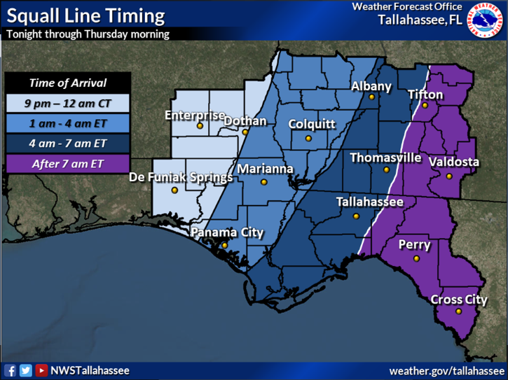
It could be a long night for residents of the capital city and neighboring communities. Scattered severe thunderstorms are possible overnight ahead of a squall line that could pose the biggest threat. The powerful line of storms is expected to push through the Tallahassee area between 4 a.m. and 7 a.m.
Tallahassee and much of North Florida remains under a tornado watch until 9 a.m.
In the storm's path:Winter storm updates: 3 killed, others trapped in tornado-battered homes in Louisiana, blizzard in North; ice headed to Northeast
ORIGINAL STORY
The same storm system that spawned deadly tornadoes to the west is expected to hit the Tallahassee area late Wednesday into Thursday, bringing the potential for damaging winds followed by a deep drop in temperatures that could persist into Christmas.
Severe storms are forecast to move into the Florida Panhandle and southeast Alabama late Wednesday night and barrel across the Big Bend on Thursday morning, according to the National Weather Service in Tallahassee.
A squall line with damaging winds and pockets of heavy rain is expected ahead of a powerful cold front, though scattered storms associated with a warm front could arrive before that, said Isreal Gonzalez, an NWS meteorologist.
“It could be potentially dangerous — no doubt about it,” Gonzalez said. “Part of the concern is not just that the environment is pretty favorable for severe weather but particularly that the threat looks to materialize the most in the overnight hours.”
Weather alert:Louisiana tornado kills 2 as twisters rake South; blizzard conditions sweep across North: Live updates
The storms could produce a few tornadoes, some possibly strong, along with damaging winds and gusts. The Tallahassee area could see an inch or two of rain.
The Storm Prediction Center is calling for a slight risk (2 on a scale of 1-5) for severe storms in Tallahassee on both Wednesday and Thursday. Points west, including Apalachicola and Marianna, have an enhanced risk (3) for severe storms.
Gonzalez said the zone under an enhanced risk has been shifting to the east, a trend that could continue.
“The potential for even significant or strong tornadoes has increased along with damaging to even destructive winds,” he said. “Hopefully that doesn’t expand anymore.”

After the storms move through, unseasonably high temperatures that have been in the 70s will drop to the low 60s on Friday and the mid-50s on Saturday and Sunday. Lows will plunge to the low 40s Thursday morning and to the high 30s by Sunday morning. Normally this time of year, Tallahassee sees highs in the mid-60s and lows in the low 40s.
The Climate Prediction Center’s long-range outlook indicates decent to high probabilities of below-normal temperatures through late December. Chances are 40-50%, which means leaning below, for Dec. 19-23, and 60-80%, which means likely below, for Dec. 21-27.

While it’s still very far out, a brief white Christmas in Tallahassee is a remote possibly. The current forecast for Dec. 25 calls for a mix of rain and snow showers.
Contact Jeff Burlew at jburlew@tallahassee.com or follow @JeffBurlew on Twitter.
This article originally appeared on Tallahassee Democrat: Tornado Warning: Dangerous storms threaten Tallahassee, north Florida

