High winds knock out power to 85,000 on Cape Cod
Editor's note: Thousands remain without power Sunday after the Cape Cod blizzard. Get the latest updates.
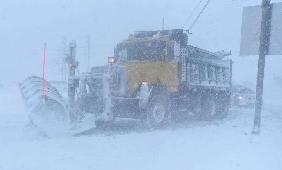
A powerful blizzard moved onto Cape Cod this morning, bringing with it promises of high winds, mounds of snow, flooding and power outages.
As of 4:15 p.m. about 42% of Eversource's customers are without power on the Cape and Martha's Vineyard, or about 85,023 customers. About 99% of Provincetown customers — or 5,955 — are still without power and have been since early this morning, according to the utility's online outage map. Barnstable, the Cape's largest town, led the top five towns with the most outages at 20,651 (82% of total customers), followed by Falmouth at 10,605 (41%), Chatham at 7,632 (89%), and Eastham at 6,123 (91%).
Some top wind gusts on Cape Cod
Recorded by the National Weather Service:
Chatham, 72 mph, 10:11 a.m.
Dennis, 68 mph, 9:46 a.m.
Orleans, 66 mph, 7:39 a.m.
West Dennis, 64 mph, 8:17 a.m.
Chapin Beach, Dennis, 63 mph, 10:12 a.m.
Orleans, 63 mph, 8:45 a.m.
Waquoit Bay, 63 mph, 8:43 a.m.
Chapin Beach, 60 mph, 7:52 a.m.
Otis AFB, 60 mph, 7:46 a.m.
West Falmouth, 58 mph, 8:34 a.m.
Snow totals around the Cape
Snowfall amounts are beginning to trickle in from National Weather Service spotters:
Hyannis, 11 inches, 12:06 p.m.
Yarmouth, 10.5 inches, 11:44 a.m.
Dennis, 9 inches, noon
Falmouth, 7.2 inches as of 9:56 a.m.
Bourne, 7 inches as of 9:22 a.m.
As of early this morning we were looking at potential snowfall amounts in excess of a couple of feet in places from the storm, wind gusts up to 70 mph and some minor to moderate flooding, according to the National Weather Service.
[This story is available to all as a public service and is made possible by our subscribers. Please consider supporting quality local journalism with a subscription to the Cape Cod Times. Here's our latest offer.]
Keep informed during the blizzard: Download the Cape Cod Times app ahead of the storm
When did the snow start on Cape Cod?
Snow began falling at about 5:30 a.m. in the Mid-Cape area. The wind, which is expected to gust up to 70 mph today, also picked up considerably.
A blizzard warning remains in effect until 5 a.m. Sunday from the weather service. Travel could be extremely difficult to impossible with very strong winds that could cause extensive tree damage. Expect considerable blowing and drifting snow along with near white-out conditions at times. Snow could fall at rates of 2 to 4 inches per hour is possible at times.
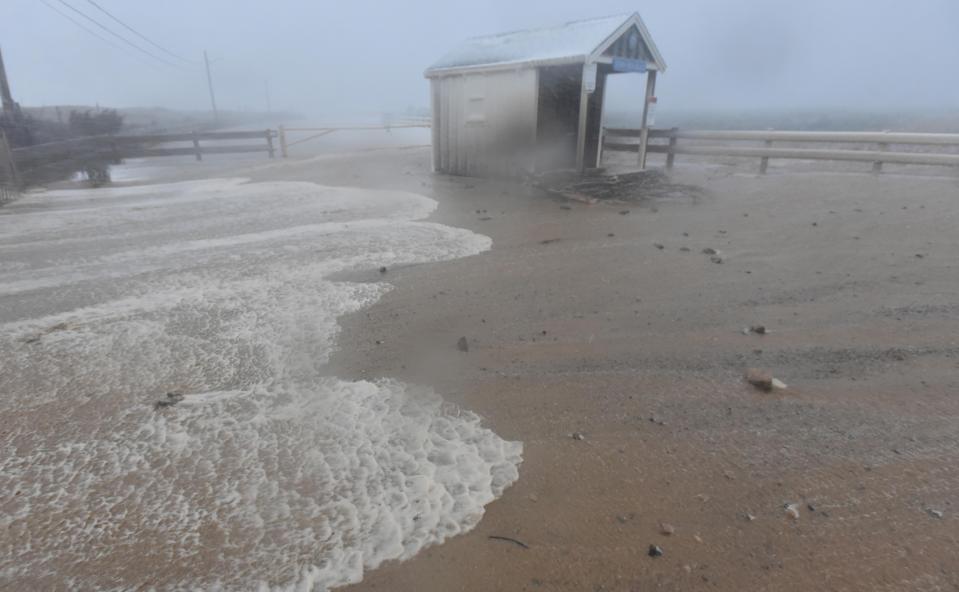
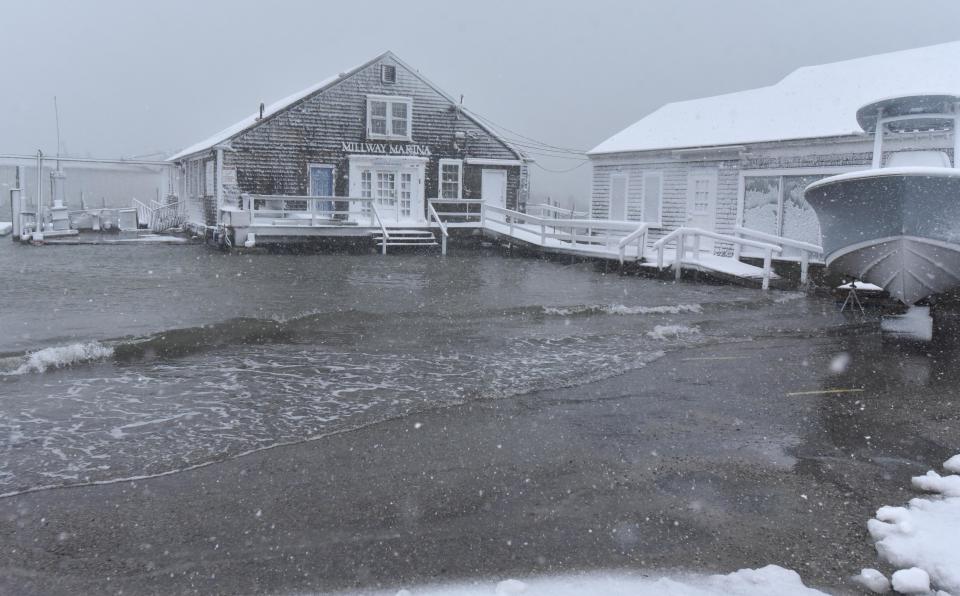
Flooding a concern this morning
A coastal flood advisory is also up, with moderate flooding expected at the high tides at around 8 a.m. in Provincetown Harbor, 9 a.m. in Sesuit Harbor in Dennis, 8 a.m. in Sandwich Harbor and 10 a.m. in Nantucket Harbor. Minor flood is forecast at 8 a.m. for the southside of Chatham.
High tide water from Cape Cod Bay breached a dune at Town Neck Beach in Sandwich at the morning high tide by the gatehouse, pouring into the parking lot and moving up the road. The area has suffered for years during storms with severe erosion and the loss of several houses.
Record snowfalls: Here are the largest single-day snowstorms in Massachusetts history
Three shelters opened this morning on Cape
The Barnstable County Regional Emergency Planning Committee opened three shelters at 6 a.m.: Falmouth High School, 874 Gifford St., Falmouth; Barnstable Intermediate School, 895 Falmouth Road, Hyannis; and Nauset Regional High School, 100 Cable Road, Eastham.
However, because blizzard conditions will make travel extremely hazardous today, and because the omicron variant of COVID-19 is still spreading, Erika Woods, deputy director of the county’s department of health and environment, said Friday that people who have the ability to seek shelter at a neighbor, friend or family member’s house should do so instead of going to a county-run shelter.
Parking bans, cancellations and other announcements
Cape Cod Hospital, Falmouth Hospital and Cape Cod Healthcare urgent care centers in Falmouth, Harwich, Hyannis and Sandwich will remain open throughout today's storm. But CCHC outpatient facilities and services will be closed today "for the safety of our patients and staff," a release from CCHC said.
The Woods Hole, Martha's Vineyard and Nantucket Steamship Authority has canceled all service today due to the storm, according to its website this morning. "We will assess the forecast later tonight to determine when service can resume on Sunday."
The National Weather Service has issued a Blizzard Warning for Cape Cod, Martha's Vineyard and Nantucket for today. Along with heavy snow, the forecast calls for wind gusts of up to 70 mph into the afternoon and evening. We will assess the forecast later tonight to determine when service can resume on Sunday.
The town of Barnstable has issued a parking ban on all main streets, said Lynne M. Poyant, director of communications, in a release. The Department of Public Works began plowing main roads at 1 a.m. and at 5 a.m. began plowing secondary roads at 5 a.m.
Dennis has a parking ban in effect from 6 a.m. today until 4 p.m. Sunday. Vehicles parked on roadways may be towed at the owner’s expense.
- Gregory Bryant
Looking back: Blizzard of ’78 remains a touchstone for New Englanders who lived through it
Friday's report
By Eric Williams/Cape Cod Times
A powerful winter storm is expected to hit Cape Cod starting late Friday, packing high winds and significant snowfall. The National Weather Service has issued a Blizzard Warning, in effect from midnight Friday to 5 a.m. Sunday.
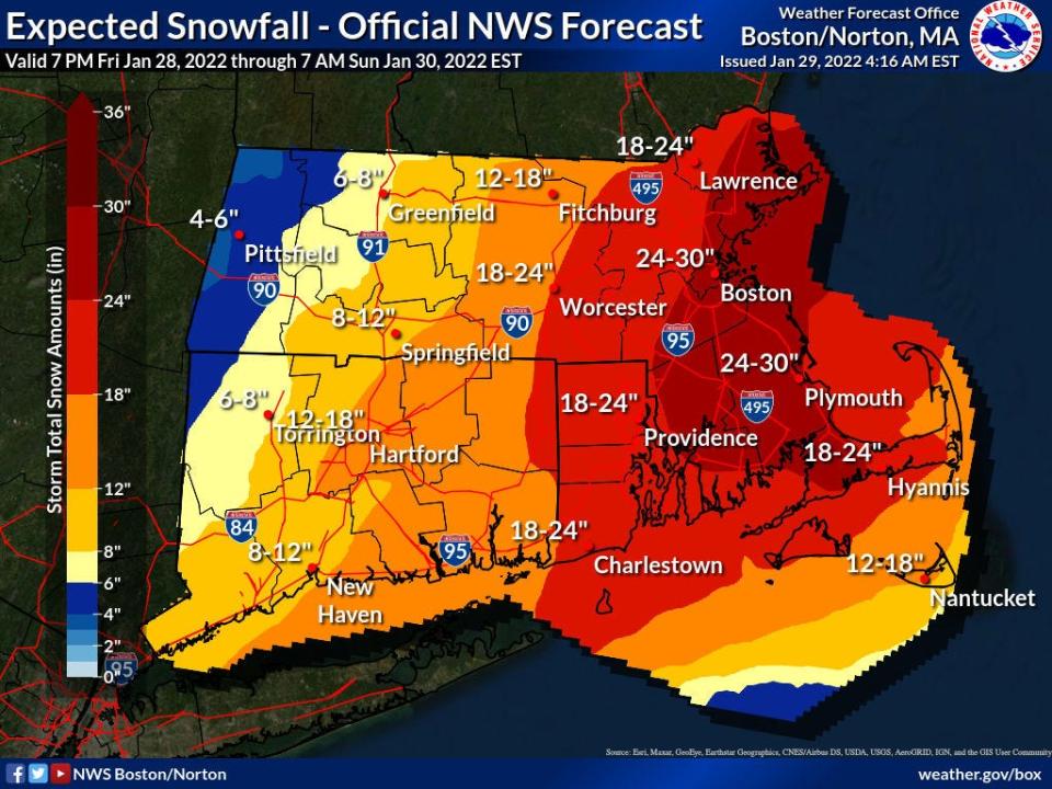
Total snow accumulations are expected to be in the 18-24 inch range and wind gusts are expected to reach 70 mph, according to forecasts.
This story is available to all as a public service and is made possible by our subscribers. Please consider supporting quality local journalism with a subscription to the Cape Cod Times. Here's our latest offer.
According to the National Weather Service, travel could be very difficult to impossible during this time frame and the strong winds could cause extensive tree damage and power outages. Snowfall rates may approach 2 to 4 inches per hour and drifting and blowing snow could cause near whiteout conditions at times.
Is this a nor'easter with a bomb cyclone: Here's what all those weather terms mean
Travel should be restricted to emergencies only, according to the National Weather Service warning. If travel is necessary, have a winter survival kit in the vehicle and if you get stranded, stay in the vehicle.
When will the snow start on Cape Cod?
The storm is expected to ramp up after midnight Friday, with heavy snow starting around 5 a.m. to 7 a.m. on Saturday.
The heavy snow will likely continue into Saturday evening, with highest snowfall totals likely across eastern Massachusetts, including Boston, Cape Cod and Martha's Vineyard, where up to two feet of snow are possible, with a low probability of up to 30 inches in isolated spots.
Coastal flooding is also a concern during the storm. According to the National Weather Service, the Saturday morning and Saturday evening high tides will be impacted. Widespread minor coastal flooding with pockets of moderate flooding are expected for both tide cycles. In the silver lining department, the timing of the storm means the strongest wind and storm surge will likely happen around the time of Saturday's afternoon low tide.
Wind gusts could reach 75 mph on the Cape on Saturday, raising concerns for power outages. According to Eversource spokesperson Chris McKinnon, the company has secured hundreds of extra repair crews to be strategically placed in locations that are expected to be hardest hit by the storm, including Cape Cod.
The online Eversource Outage Map is a helpful tool for folks to track and report power outages.
House on the edge in Truro
The Ballston Beach parking lot has been closed in Truro, due to the possibility of coastal flooding and erosion during the storm. According to a press release from the town of Truro, the town will be monitoring homes along South Pamet Road that are at risk from erosion as the storm progresses.
A home at 133 South Pamet Road, Ballston Beach, located on a dune above the beach, was further imperiled during a storm on Jan. 17, when approximately 20 feet of dune was washed away from the ocean side of the property.
According to the Truro press release, the property owner is working to reinforce and stabilize three pilings under the house before the storm arrives.
Latest on regional shelters in county
Barnstable County officials will likely open shelters at three locations: Falmouth High School, 874 Gifford St., Falmouth; Barnstable Intermediate School, 895 Falmouth Road, Hyannis; and Nauset Regional High School, 100 Cable Road, Eastham.
However, because blizzard conditions will make travel extremely hazardous Sunday, and because the omicron variant of COVID-19 is still spreading, Erika Woods, deputy director of the county’s department of health and environment, said Friday that people who have the ability to seek shelter at a neighbor, friend or family member’s house should do so instead of going to a county-run shelter.
“We want to make the shelters available and they are available, but if it is at all possible for people to contact neighbors, family members, somebody else that they could stay with, that would be the better option,” Woods said.
Woods said the county hasn’t decided exactly when the shelters will open yet, and advised people to check the county’s website and social media channels for updates.
Emergency preparedness officials across multiple agencies and organizations spent Friday morning consulting about how to keep Cape residents safe amid the weekend blizzard expected to bring high winds and lots of snow.
Key support staff with Barnstable County have opened the county's Multi-Agency Coordination Center, or MACC, in Barnstable Village, Woods said. More staff will gather there Friday evening and Saturday morning, she said.
The Barnstable County Regional Emergency Planning Committee yesterday began hosting twice-daily conference calls at 10 a.m. and 4 p.m. to ensure agencies are coordinating on storm response.
On Friday morning, more than 200 people joined the conference call, including Acting Massachusetts Emergency Management Agency Director Dawn Brantley, officials with Eversource and Comcast, Cape town officials, and representatives from volunteer organizations that will assist with storm response, including Red Cross, AmeriCorps and the Medical Reserve Corps.
Volunteers with those organizations will staff regional shelters that county officials expect to open early tomorrow morning, as blizzard-caused power outages are possible, especially on the Outer and Lower Cape.
If you get trapped in your home and need help, call 911.
“If you need transport, call your local ambulance and don't wait till the last minute because obviously they're going to have a hard time getting out to people,” Woods said.
Storm preparedness at Cape Cod hospitals
Cape Cod Healthcare Senior Vice President of Communications Patrick Kane said the hospital system has implemented its standard storm protocol, which includes checking and topping off generators, securing housing for hospital staff between shifts as needed, communicating with governmental and social service agencies as well as activating “snow teams” – groups of employees who shovel walkways, run equipment, clear parking lots and spread salt.
Woods said that people should avoid traveling at all tomorrow, and should use today to stock up on emergency supplies.
“The travel is going to be horrible,” she said. “It's going to be blizzard conditions with very, very heavy snow. So definitely do all your preparations today and stay at home, stay off the roads so that the emergency medical staff and everyone can get around and not have to be out there saving us.”
Jim Morton, longtime store manager at Baskin’s ACE Hardware in Orleans, said many Cape residents began to prepare two days ago, and the customers haven’t stopped coming since.
The store got a new shipment of inventory Friday morning, and supplies have already depleted.
“We actually had people here first thing in the morning, so we've depleted what I got in,” Morton said.
Morton said that, in addition to builders buying tarps, sheeting and kerosene heaters to protect exposed job sites and elderly women coming in to check that their flashlights are ready, he is seeing an influx of people who are new to Cape Cod and its brutal storms, many of whom moved here during the pandemic.
The store has sold 21 generators ahead of the storm, Morton said, a first in his 40 years on the job.
“It’s incredible,” he said. “The last storm hit a lot of folks that hadn't lived here previously, and they're buying things that can keep them functioning normally. The folks that haven’t lived here need a snowblower, snow shovels, they need an electric heater, maybe. So we’ve gotten a lot of that.”
While in-person business has reached typical pre-storm levels, Morton said online ordering has skyrocketed to unprecedented levels.
“We did at least 60% more online in addition to what walks in the door,” he said.
Cape Cod National Seashore announced that access points to all six Seashore beaches will be closed for the duration of the storm until safe access can be provided. The same goes for Province Lands Road in Provincetown and Marconi Site Road in South Wellfleet. The Salt Pond Visitor Center in Eastham will be closed on Saturday and Sunday.
This article originally appeared on Cape Cod Times: Cape Cod blizzard: Live coverage of snowfall totals, power outages

