Pre-Christmas storm brings rain, powerful wind to region; knocks out power for thousands
A "high-impact storm" that moved into Southern New England Thursday night with heavy rain and powerful winds has knocked out power to several thousand in Rhode Island, prompted an early holiday break at some schools, flooded streets and forced the cancellation of some flights at Rhode Island's major airport.
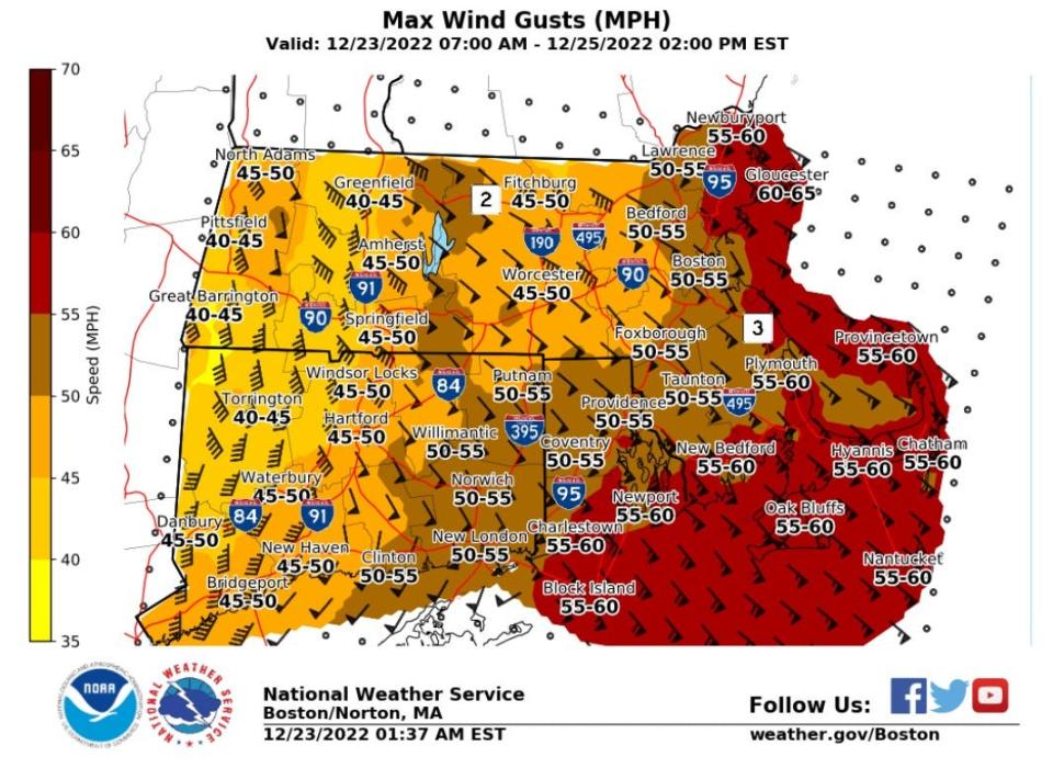
The storm has brought sustained winds of 20 to 30 mph with some reported gusts of 50 to 55 mph, but the strongest winds — up to 65 mph along the coast and 50 mph inland — weren't expected to hit Rhode Island and the eastern part of Massachusetts until after sunrise, the National Weather Service said in its forecast discussion and on Twitter.
Power outages, school closings and travel restrictions

More than 9,000 electric customers were without power as of about 9:30 a.m., according to Rhode Island Energy's power outage map, with the bulk of them — 5,176 — in Providence County. Kent County also had 2,746 without power.
Some schools, including Scituate public schools and the Chariho Regional School District, canceled classes, according to the Rhode Island Broadcasters Association. Many other school systems, including Providence, have already started their winter break
Major storm is moving across country:Here's what to expect in Rhode Island
Some morning flights have been canceled at Rhode Island T.F. Green International Airport, but the airport's website shows early morning flights to Philadelphia, Atlanta and Orlando have departed.
The Rhode Island Turnpike and Bridge Authority restricted travel across the Newport Pell and Jamestown bridges, until 9:30 a.m. saying in a tweet, "Due to high winds only automobiles, pickup trucks, flatbed trailers, and commercial buses are permitted to cross the Newport Pell, and Jamestown Bridges at this time."
A high wind warning will remain in effect until 7 a.m. Saturday.
Flooding blocked access to Wickford Village for a while Friday morning, according to the North Kingstown Police Department. "The area has been closed off at Post Road at West Main Street, Phillips Street at Boone Street, and Boston Neck Road at Brown Street," the police said in a Facebook post. By about 11:30 a.m., all roads had been reopened.
Flooding also closed parts of Succotash and Middlebridge roads in South Kingstown, according to the South Kingstown Police Department, which is urging people to stay off the roads, if possible.
With waves pouring onto the road, the Portsmouth Police Department is asking drivers to avoid Park Avenue. The DOT "currently has Park Ave at Aquidneck Ave blocked, Boyd’s Ln at Norseman Drive blocked and Park Ave at Schultzy’s blocked," the police said on Facebook.
"If you need to get in, or get out of Island Park, please use the Hummocks End."
A flood warning is in effect for Rhode Island's Washington and Bristol counties, as well as coastal areas in Kent and Providence counties.
"Minor coastal flooding is expected in the lowest lying areas (of) Newport, Portsmouth and Middletown," the Weather Service said. "A few immediate coastal roads flood due to wave action. Minor coastal flooding occurs in the Common Fence Point area of Newport."
Park Ave at Schultzy’s pic.twitter.com/tq4AVLYX5j
— Portsmouth Police RI (@PortsmouthPDRI) December 23, 2022
In East Providence, the Rhode Island Department of Transportation closed a section of Veterans Memorial Parkway between Lyon Avenue and South Broadway because of flooding, the police said.
All ferries to and from Block Island have been canceled for Friday, according to The Block Island Ferry. The ferry service says it will monitor forecasts for Saturday and advises customers to check their website for updates. The National Weather Service has issued a storm warning until 7 p.m. for Block Island and Rhode Island sounds for winds up to 50 knots and 9- to 14-foot seas.
"Very strong winds will cause hazardous seas, which could capsize or damage vessels and reduce visibility," the Weather Service said, advising that stay in port or alter course.
Looking ahead past Friday morning
As the storm moves away today, a strong arctic cold front will move into the region this afternoon and the temperature will plummet from a high of about 54 degrees in Providence Friday morning to a low of about 13 degrees overnight, the Weather Service says.
The wind will shift to come out of the southwest but lessen only slightly, gusting up to 45 to 55 mph, after the cold front moves into Southern New England, the Weather Service says.
The Rhode Island Department of Transportation is "closely monitoring weather conditions," according to a spokesman for Gov. Dan McKee, and 150 state plow trucks, along with 250 vendor trucks are available to treat roads.
"The initial application will be timed prior to temperatures dropping below freezing, but motorists should be wary of possible icing conditions," spokesman Matthew Sheaff said in an email.
"RIDOT recommends that drivers reduce their speed, and never drive through flood-covered roadways," Sheaff said. "Especially as temperatures fall into the afternoon, they should provide additional distance for stopping.
The DOT prepared ahead of the storm by clearing storm drains and coordinating with contractors to secure construction sites, Sheaff said.
DOT crews reported at midnight last night and "are available to assist with any flooding issues or downed limbs or trees," Sheaff said.
A list of warming centers is available on the Rhode Island Emergency Management Agency's website.
This article originally appeared on The Providence Journal: Storm moves into RI with rain, powerful wind; temperatures to drop

