How a precipitation ‘doughnut hole’ makes Pueblo drier and warmer than most of Colorado
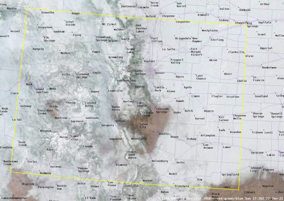
A recent satellite image showing snow throughout Colorado offered a glimpse and insight into a novel southern Colorado weather phenomenon: the Pueblo Precipitation Doughnut Hole.
The image, released by the National Weather Service of Pueblo, showed that most of Colorado received snowfall on Jan. 20, with some cloud cover mixed in. But there was one specific area that missed out on the precipitation, which encompassed portions of east and northern Pueblo County, as well as portions of Cañon City and some of Colorado Springs.
That area is the home of the Pueblo Precipitation Doughnut Hole, a cross-section of terrain from south to north that tends to receive less precipitation than the areas surrounding it because of different geographical features such as Raton Mesa, the Arkansas River Valley, Palmer Divide and the surrounding mountains.
Those features are key contributors to how winds and precipitation materialize in the region, the NWS Pueblo office wrote in a Twitter thread.
“It’s all about terrain, elevation and elevation change,” said Michael Garberoglio, an NWS meteorologist. “If you’re moving towards Pueblo from any direction, you’re decreasing in elevation, and when air flows down, terrain tends to dry out.”
Precipitation isn’t a fan of that sinking air flow, so those downslope winds contribute to dry and warmer climates for the region, Garberoglio said. It’s something that’s much more common during winter, especially when dealing with snowfall.
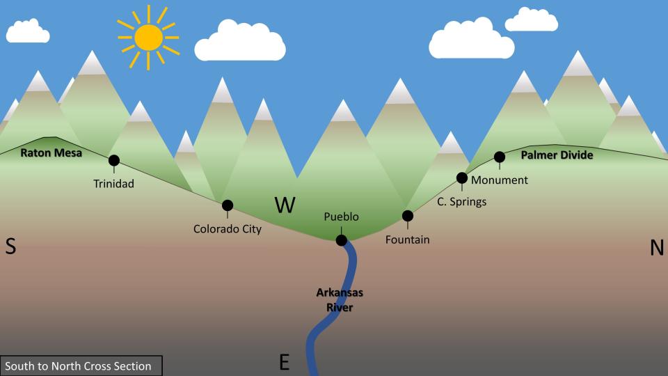
“A lot of times in this part of the country, we do tend to see more westerly winds over the mountain, so those will usually downslope into Pueblo more often than not,” Garberoglio said. “That leads into a lot of our drier-than-average conditions.”
Although westerly winds are frequent in the region, intense, low-pressure easterly winds upslope along the terrain, enhancing the possibility for some precipitation, Garberoglio said, as long as they’re strong enough and have enough moisture in them.
The downslope winds and terrain features at times can be overpowered by convective activity, such as a thunderstorm that can come down from the Palmer Divide or drift in from somewhere else to provide moisture to the area.
“Updrafts with these thunderstorms are usually strong enough to where they overpower that downsloping, drying effect,” Garberoglio said. “The thunderstorm might be weakening as it comes down (the slope), it still holds together until it gets to Pueblo.”
The “doughnut hole” does have some disadvantages. Less moisture in the region impacts people who want to grow crops and increases the risk for wildfires, Garberoglio said. But less rain means better conditions to host outside gatherings or community events.
“It might be sunny 320 days a year here, but there's still that risk of fires and we obviously have to deal with the drought, getting enough moisture to keep things running,” Garberoglio said.
A map from the Colorado Climate Center illustrates the state’s annual average precipitation and further shows the impact of the “doughnut hole.” In that map, northern Pueblo County and the area shortly south of it are drier than surrounding areas, according to data that was collected between 1991 and 2000.
“Pueblo tends to get missed more often than not,” Garberoglio said. “This is something that you can see more and more of as you look at longer stretches of time.”
Chieftain reporter Josue Perez can be reached at JHPerez@gannett.com. Follow him on Twitter @josuepwrites.
This article originally appeared on The Pueblo Chieftain: NWS Pueblo shares insight into Pueblo precipitation 'doughnut hole'

