Proposed map classifies 96% of rural Ventura County in 'very high' fire zone

Nearly all of rural, unincorporated Ventura County may be at "very high" fire risk, according to a hazard zone map proposed by the California Department of Forestry and Fire Protection.
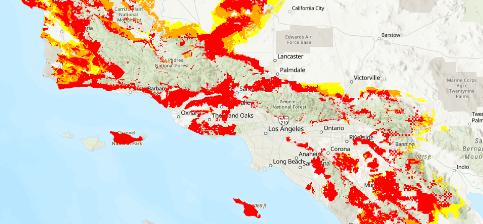
The map ranks rural, unincorporated areas throughout the state based on how likely they are to experience wildfires. It classifies locations in three zones – moderate, high and very high.
The proposed changes show an increase in fire hazard in the county and statewide since the map was last updated in 2007.
Around 17 million acres or nearly 55% of California's rural, unincorporated areas were included in the "very high" zone in the proposal. That's up 14.6% from the older map.
See full map:Click here to view the interactive map
In Ventura County, the proposed "very high" category includes more than 341,000 acres – or 96% of the rural, unincorporated area – up 21% from the 2007 version.
The increase came as little surprise to local fire officials, said Massoud Araghi, fire marshal with the Ventura County Fire Department. In recent years, the county experienced devastating wildfires, he said.
In December 2017, the Thomas Fire burned nearly 282,000 acres in Ventura and Santa Barbara counties. Two people died and 1,063 structures were destroyed.
Nearly a year later, three people died in the Woolsey Fire that burned close to 97,000 acres and destroyed more than 1,600 structures in Ventura and Los Angeles counties.
Cal Fire's proposed map only includes unincorporated, rural locations in California where the state has the responsibility to respond to fires. It does not include cities or large urban regions.
Scientists considered wildfire history, predicted flame length, blowing embers, typical fire weather and other factors, according to Cal Fire.
A designation change for an area does not affect what current regulations apply to the properties, officials said. Requirements such as real estate disclosures and building codes already applied consistently to all three zones, Araghi said.
Locally, officials will take comments on the proposed map at a hearing at 1 p.m. Tuesday in Freedom Center, 515 Eubanks St. in Camarillo.
Send written comments on the proposed map by Feb. 3 to FHSZcomments@fire.ca.gov or to the Office of the State Fire Marshal, C/O: FHSZ Comments, California Department of Forestry and Fire Protection, P.O. Box 944246, Sacramento, CA 94244-2460.
Cheri Carlson covers the environment and county government for the Ventura County Star. Reach her at cheri.carlson@vcstar.com or 805-437-0260.
This article originally appeared on Ventura County Star: Map lists most of rural Ventura County at very high fire risk

