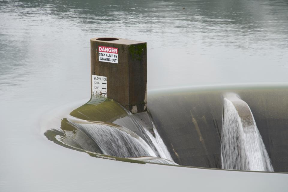
'Emergency overflow valve' at Whiskeytown Lake spills for the first time in 2024
Recent heavy rains over western Shasta County pushed the level of Whiskeytown Lake so high that for the first time this year, the Glory Hole began spilling over this week.
Water last flowed down into the Glory Hole in 2023 and before that in 2019. For most of the year, the 24-foot diameter concrete orifice juts up above the surface of the lake and is visible from near Whiskeytown Dam.
But when rains get heavy and the lake level rises high enough, water goes over the top and plunges down 260 feet into the Glory Hole, where it makes a sharp turn and then runs underneath the dam. Lake water then flows out the other side of the dam into Clear Creek.
In other words, the Glory Hole is Whiskeytown Dam's gigantic emergency overflow valve.
When the Glory Hole does overflow, visitors often stop to snap photos from the small parking lot near the bas-relief panels at the John F. Kennedy Memorial that marks the date on Sept. 28, 1963, when the former president visited the area to dedicate the new dam and lake.
What to know about the Glory Hole: Rains make curiosity rise whether Whiskeytown Lake's 260-foot-deep Glory Hole will be used
The Whiskeytown Lake area received nearly 2.5 inches of rain in the 24 hours ending at 5 p.m. Monday, according to the National Weather Service. The higher rainfall and water flowing into the lake from its tributaries pushed the water level above the rim of the Glory Hole.
The Glory Hole, so called because of its resemblance to a morning glory flower, is one of three outlets from the lake at the dam.
Note to readers: If you appreciate the work we do here at the Redding Record Searchlight, please consider subscribing yourself or giving the gift of a subscription to someone you know.
There are two lower outlets beneath the surface of the lake and under the dam. The upper outlet is 100 feet below the Glory Hole, and the lower outlet is another 135 feet down, which allows bureau officials to let colder water out of the lake to benefit salmon that live in Clear Creek below the dam and in the Sacramento River, Bader said.
Ask the Record Searchlight: How did Whiskeytown's Glory Hole get its name? Where does the water go?
There is also an outlet near the Whiskeytown Visitors Center which leads to penstocks that take water several miles to the Spring Creek Power House near Keswick Lake.
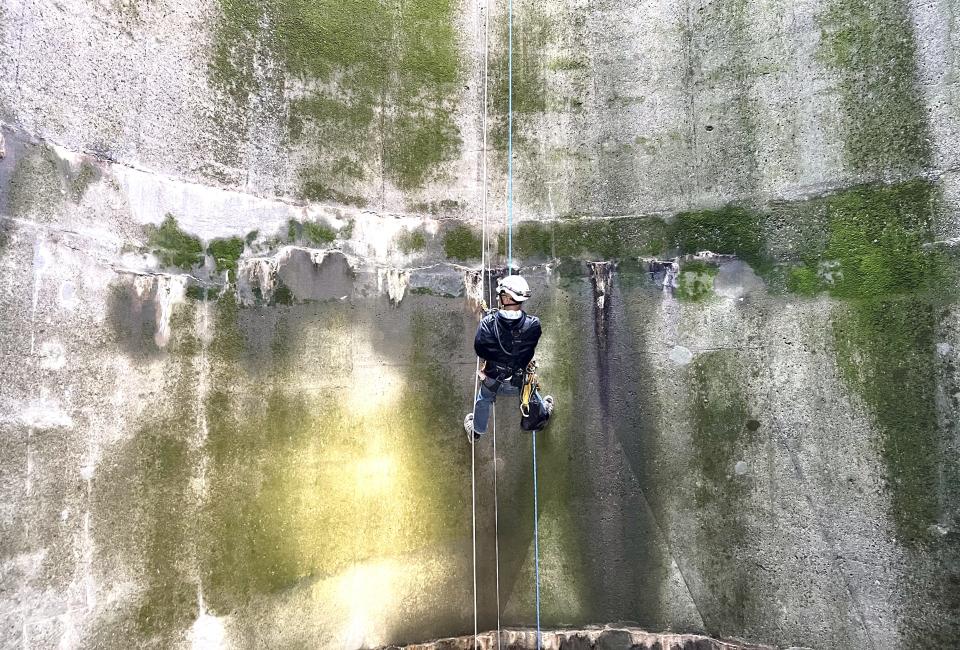
A crew inspected the Glory Hole earlier in January to make sure it is working properly and is structurally sound, according to the U.S. Bureau of Reclamation. Officials said they did not see any problems after two members of the crew rappelled down into the spillway.
Dig deeper: Inspection team descends 260 feet down into Whiskeytown Dam's Glory Hole spillway
Whiskeytown National Recreation Area Superintendent Josh Hoines said on Wednesday that with more rain in the forecast, water may continue to flow down into the Glory Hole for the rest of the week.
Reporter Damon Arthur welcomes story tips at 530-338-8834, by email at damon.arthur@redding.com and on X, formerly known as Twitter, at @damonarthur_RS. Help local journalism thrive by subscribing today!
This article originally appeared on Redding Record Searchlight: Glory Hole at Whiskeytown Lake spills for the first time in 2024

