Quebec’s rainiest-ever December storm is likely on Monday
This will go down as one strange month in Quebec’s weather history. Just weeks after Montreal witnessed one of its largest snowstorms so early in the year, a significant swath of Quebec faces the prospect of its rainiest-ever December storm.
The major low-pressure system brewing south of the border will drag a deep plume of tropical moisture into Quebec, fuelling rainfall rates that will send storm totals into record territory for this time of year.
Localized flooding is possible where the heaviest rains fall, as well as across communities where heavy rain falls on existing snowpack.
DON’T MISS: Canada will see the world’s largest weather anomaly on Monday
Province’s largest December rainstorm likely on tap
This is a pretty rare storm for a week before Christmas Day. It’s usually far too cold by this point in the season for the atmosphere to hold this much moisture. But this powerful storm will march in with plenty of tropical moisture, which will fuel significant rainfall across the province.

Heavy rain will pick up through the pre-dawn hours Monday and increase in intensity through the day. Heavy rainfall rates of 10+ mm per hour are possible.
Going somewhere? Check out the current highway conditions before heading out!
This will result in widespread rainfall totals of 50-75 mm from Montreal up the length of the St. Lawrence River, with the heaviest totals possible around and north of Quebec City. Some areas here could see 100+ mm of rain.
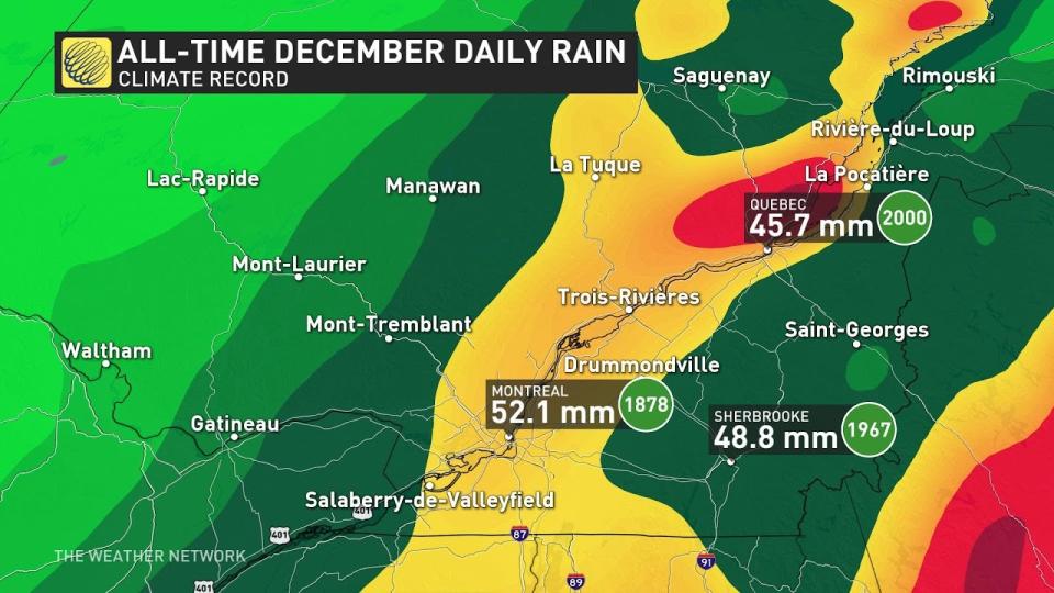
Daily rainfall records here hover between 40-50 mm, which seem easily achievable through the duration of this storm.
A glut of rain falling this quickly will lead to localized flooding in the hardest-hit areas. Communities with a healthy snowpack are at heightened risk for flooding, as heavy rain and very warm temperatures infuse the runoff with rapid snowmelt.
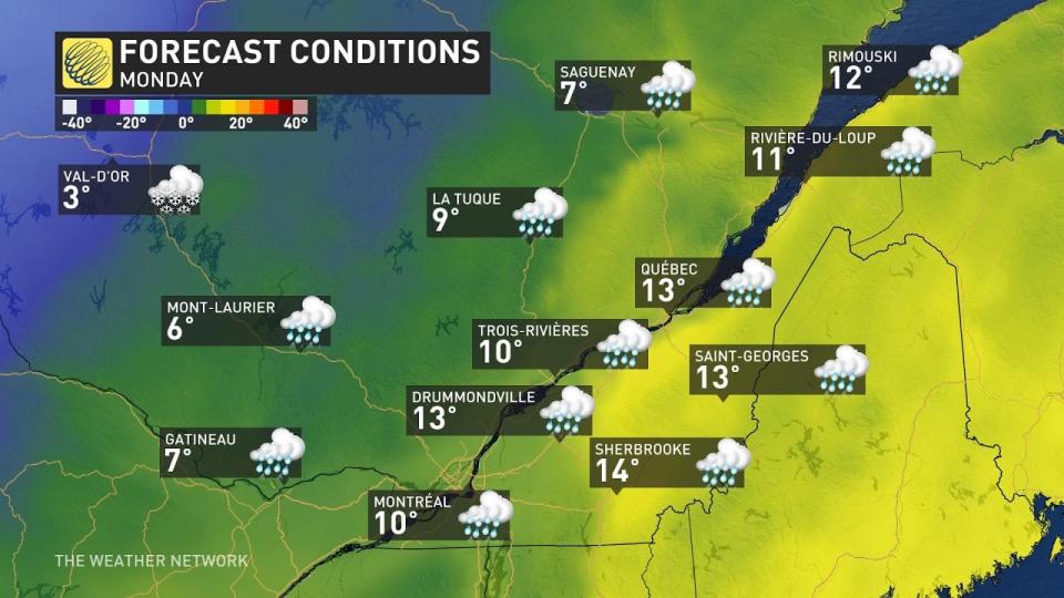
We’ll see very warm temperatures through the day Monday as this storm pushes through the province. Daytime temperatures will come in as much as 20 degrees above-seasonal for this point in December. Quebec City could see its warmest day ever recorded in December if the high reaches the predicted 14°C.
WINTER 2024: El Niño will play a critical role in the weeks ahead
Cooler air will wrap in behind the storm after the rainfall tapers off on Monday night, pushing temperatures a little closer to the realm of seasonal.
Mild weather will return for Wednesday with some sunshine. Temperatures could be near or above seasonal through next weekend across southern Quebec, but it also includes a chance for quick doses of colder weather for the region, even extending west into eastern Ontario.
At this point, the odds of white Christmas are quite low across the province. However, it is still too early to completely rule out a white Christmas for parts of the region –– it could still be cold enough around Dec. 23-25 for a system that we can’t yet see to bring a coating of snow.
Stay with The Weather Network for the latest on your forecast across Quebec.

