Quick-hitting Alberta Clipper to bring covering of snow to parts of Midwest, Northeast
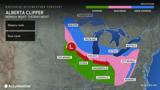


AccuWeather forecasters say a quick-hitting storm, known as an Alberta Clipper, is forecast to usher in nuisance rain and snow showers from Minnesota to Maryland during the first days of the new week.
"This system is expected to quickly dive through the Midwest early this week, which will put some large metropolitan areas in line for a round of snowfall," AccuWeather Meteorologist Brandon Buckingham said.
Wintertime storms that originate from the Canadian province of Alberta and tend to move swiftly along in a southward dip of the jet stream around the Great Lakes and Northeast are referred to as Alberta clippers.
This particular clipper is poised to dive into North Dakota on Monday, reaching the western Great Lakes during Monday night, Ohio Valley by Tuesday and exiting the United States off the mid-Atlantic coast on Tuesday night.
To the south of the track of the storm, rain or a mixture of rain and snow is expected, with all snow forecast farther to the north.
 |
Precipitation is expected to be light and mainly a nuisance for most along the path of the clipper; however, AccuWeather meteorologists say there can be a few areas where slippery spots develop, especially in higher elevations and where snow falls at night.
"As the clipper dives to the southeast, cities like Milwaukee, Wisconsin; Chicago; and Grand Rapids and Detroit, Michigan; may be in line for some light snow. In many of these areas, temperatures can be within a few degrees of freezing, so any accumulation will largely be limited to non-paved surfaces," Buckingham said.
"The window to watch for potential issues on roadways will occur Monday night as temperatures drop well enough below freezing. The current forecast highlights this zone to reside along a path between Minneapolis to Madison, Wisconsin, overnight Monday," Buckingham said.
Have the app? Unlock AccuWeather Alerts™ with Premium+
By Tuesday morning, residents in and around the Cleveland metro area may step outside with snowflakes falling.
Heading into Tuesday night, the clipper is expected to track into the central Appalachians and mid-Atlantic states.
"By this point, snowfall accumulations will likely end up being elevation-based, but it is not out of the realm of possibility for at least a few slushy inches of snow to fall in the high terrain of southwestern Pennsylvania, western Maryland and West Virginia," Buckingham said.
Precipitation from this system will mainly stay south of the areas in New England where 6-12 inches of snow can fall as the new week begins.
Chilly but generally seasonable air will persist across the Midwest and Northeast as the clipper system moves along. Along the Northeast coast, temperatures can dip several degrees below the historical average by the middle of the week as breezy conditions make it feel even cooler.
Want next-level safety, ad-free? Unlock advanced, hyperlocal severe weather alerts when you subscribe to Premium+ on the AccuWeather app. AccuWeather Alerts™ are prompted by our expert meteorologists who monitor and analyze dangerous weather risks 24/7 to keep you and your family safer.
